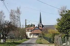
Saint-Viâtre
Saint-Viâtre is a commune in the Loir-et-Cher department in central France.
Saint-Viâtre | |
|---|---|
Commune | |
 | |
.svg.png.webp) Coat of arms | |
Location of Saint-Viâtre 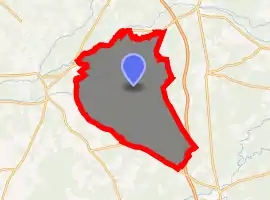
| |
 Saint-Viâtre  Saint-Viâtre | |
| Coordinates: 47°31′27″N 1°56′03″E | |
| Country | France |
| Region | Centre-Val de Loire |
| Department | Loir-et-Cher |
| Arrondissement | Romorantin-Lanthenay |
| Canton | La Sologne |
| Intercommunality | Sologne des étangs |
| Government | |
| • Mayor (2014–2020) | Christian Léonard |
| Area 1 | 89.79 km2 (34.67 sq mi) |
| Population (2017-01-01)[1] | 1,196 |
| • Density | 13/km2 (34/sq mi) |
| Time zone | UTC+01:00 (CET) |
| • Summer (DST) | UTC+02:00 (CEST) |
| INSEE/Postal code | 41231 /41210 |
| Elevation | 92–132 m (302–433 ft) (avg. 108 m or 354 ft) |
| 1 French Land Register data, which excludes lakes, ponds, glaciers > 1 km2 (0.386 sq mi or 247 acres) and river estuaries. | |
History
The village was originally called Tremblevif, from the Latin for "aspen" and "village", but suggesting in the popular imagination a place prone to swamp fever and trembling limbs. In 1854, worried that outsiders might be put off, the villagers successfully petitioned to change the name to Saint-Viâtre [2] in honour of a hermit, traditionally known as Viâtre, who had lived in the forests of Sologne. His tomb is in the crypt of the village church.
Population
| Year | Pop. | ±% |
|---|---|---|
| 1793 | 988 | — |
| 1806 | 1,022 | +3.4% |
| 1821 | 1,095 | +7.1% |
| 1831 | 1,257 | +14.8% |
| 1841 | 1,194 | −5.0% |
| 1851 | 1,240 | +3.9% |
| 1861 | 1,255 | +1.2% |
| 1872 | 1,361 | +8.4% |
| 1881 | 1,531 | +12.5% |
| 1891 | 1,742 | +13.8% |
| 1901 | 1,844 | +5.9% |
| 1911 | 1,854 | +0.5% |
| 1921 | 1,623 | −12.5% |
| 1931 | 1,591 | −2.0% |
| 1946 | 1,469 | −7.7% |
| 1954 | 1,314 | −10.6% |
| 1962 | 1,282 | −2.4% |
| 1968 | 1,245 | −2.9% |
| 1975 | 1,223 | −1.8% |
| 1982 | 1,162 | −5.0% |
| 1990 | 1,063 | −8.5% |
| 1999 | 1,157 | +8.8% |
| 2006 | 1,188 | +2.7% |
| 2015 | 1,236 | +4.0% |
References
- "Populations légales 2017". INSEE. Retrieved 6 January 2020.
- Graham Robb, The Discovery of France, Picador, London (2007), p.304, quoting Onésime Reclus. France, Algérie et colonies (1866), p.133
| Wikimedia Commons has media related to Saint-Viâtre. |
| Authority control |
|---|
This article is issued from Wikipedia. The text is licensed under Creative Commons - Attribution - Sharealike. Additional terms may apply for the media files.