La Ville-aux-Clercs
La Ville-aux-Clercs is a commune in the Loir-et-Cher department in central France.
La Ville-aux-Clercs | |
|---|---|
Commune | |
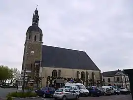 Church of Saint Bartholomew | |
.svg.png.webp) Coat of arms | |
Location of La Ville-aux-Clercs 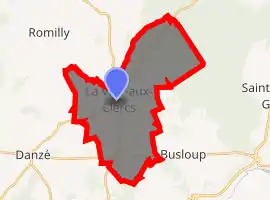
| |
 La Ville-aux-Clercs  La Ville-aux-Clercs | |
| Coordinates: 47°55′09″N 1°05′09″E | |
| Country | France |
| Region | Centre-Val de Loire |
| Department | Loir-et-Cher |
| Arrondissement | Vendôme |
| Canton | Le Perche |
| Intercommunality | Pays de Vendôme |
| Government | |
| • Mayor (2014–2020) | Isabelle Maincion |
| Area 1 | 26.61 km2 (10.27 sq mi) |
| Population (2017-01-01)[1] | 1,273 |
| • Density | 48/km2 (120/sq mi) |
| Time zone | UTC+01:00 (CET) |
| • Summer (DST) | UTC+02:00 (CEST) |
| INSEE/Postal code | 41275 /41160 |
| Elevation | 115–195 m (377–640 ft) (avg. 142 m or 466 ft) |
| 1 French Land Register data, which excludes lakes, ponds, glaciers > 1 km2 (0.386 sq mi or 247 acres) and river estuaries. | |
Population
|
|
References
- "Populations légales 2017". INSEE. Retrieved 6 January 2020.
| Wikimedia Commons has media related to La Ville-aux-Clercs. |
| Authority control |
|---|
This article is issued from Wikipedia. The text is licensed under Creative Commons - Attribution - Sharealike. Additional terms may apply for the media files.