Bonanza, Colorado
The Town of Bonanza is a Statutory Town located in Saguache County, Colorado, United States. Formerly known as Bonanza City, Bonanza is a largely abandoned former silver mining town. Bonanza is a Spanish language word meaning prosperity. The town population was 16 at the 2010 United States Census, ranking Bonanza as the second least populous municipality in the State of Colorado.[7] The Villa Grove Post Office (ZIP Code 81155) now serves Bonanza.[6]
Town of Bonanza, Colorado | |
|---|---|
Statutory Town | |
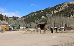 Main Street and 1st Avenue in Bonanza. | |
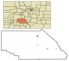 Location of Bonanza in Saguache County, Colorado. | |
 Town of Bonanza, Colorado Location in the United States | |
| Coordinates: 38°17′48″N 106°08′31″W[1] | |
| Country | |
| State | |
| County | Saguache County[2] |
| Incorporated | 1881-01-13, as the Town of Bonanza City[3] |
| Government | |
| • Type | Statutory Town[2] |
| Area | |
| • Total | 0.44 sq mi (1.13 km2) |
| • Land | 0.44 sq mi (1.13 km2) |
| • Water | 0.00 sq mi (0.00 km2) |
| Elevation | 9,478 ft (2,889 m) |
| Population (2010) | |
| • Total | 16 |
| • Estimate (2019)[5] | 19 |
| • Density | 43.48/sq mi (16.78/km2) |
| Time zone | UTC-7 (MST) |
| • Summer (DST) | UTC-6 (MDT) |
| ZIP Code | Villa Grove CO 81155[6] |
| FIPS code | 08-07571 |
| GNIS feature ID | 0189929 |
| Highways | none |
History
In 1880, Tom Cooke of Salida, Colorado stumbled upon ore deposits while searching for horses. Prospectors flocked to this location and the town of Bonanza City was founded. In the first two years of its existence, its population ballooned to between 1,000 and 1,500. At the time, population of mining towns was determined by the number of saloons and dance halls instead of a census taker and at this time, Bonanza City had 36 saloons and 7 dance halls.[8]
Geography
Bonanza is located at 38°17′42″N 106°8′25″W (38.295138, −106.140158)[9] at an altitude of 9500 feet.
According to the United States Census Bureau, the town has a total area of 0.4 square miles (1.0 km2), all of it land.
Demographics
| Historical population | |||
|---|---|---|---|
| Census | Pop. | %± | |
| 1890 | 96 | — | |
| 1900 | 141 | 46.9% | |
| 1910 | 96 | −31.9% | |
| 1920 | 91 | −5.2% | |
| 1930 | 445 | 389.0% | |
| 1940 | 140 | −68.5% | |
| 1950 | 51 | −63.6% | |
| 1960 | 19 | −62.7% | |
| 1970 | 10 | −47.4% | |
| 1980 | 8 | −20.0% | |
| 1990 | 16 | 100.0% | |
| 2000 | 14 | −12.5% | |
| 2010 | 16 | 14.3% | |
| 2019 (est.) | 19 | [5] | 18.8% |
| U.S. Decennial Census[10] | |||
As of the census[11] of 2000, there were 14 people, 7 households, and 3 families residing in the town. The population density was 31.9 people per square mile (12.3/km2). There were 33 housing units at an average density of 75.3 per square mile (29.0/km2). The racial makeup of the town was 71.43% White, 7.14% Asian, and 21.43% from two or more races.
There were 7 households, out of which 14.3% had children under the age of 18 living with them, 42.9% were married couples living together, and 57.1% were non-families. 42.9% of all households were made up of individuals, and none had someone living alone who was 65 years of age or older. The average household size was 2.00 and the average family size was 3.00.
In the town, the population was spread out, with 7.1% under the age of 18, 28.6% from 18 to 24, 14.3% from 25 to 44, 50.0% from 45 to 64, . The median age was 44 years. For every 100 females, there were 180.0 males. For every 100 females age 18 and over, there were 160.0 males.
The median income for a household in the town was $63,750, and the median income for a family was $27,000. The per capita income for the town was $66,857. None of the population and none of the families were below the poverty line.
See also
- Outline of Colorado
- State of Colorado
- Colorado cities and towns
- Colorado municipalities
- Colorado counties
- Colorado cities and towns
References
- "2014 U.S. Gazetteer Files: Places". United States Census Bureau. July 1, 2014. Retrieved January 5, 2015.
- "Active Colorado Municipalities". State of Colorado, Department of Local Affairs. Archived from the original on December 12, 2009. Retrieved 2007-11-30.
- "Colorado Municipal Incorporations". State of Colorado, Department of Personnel & Administration, Colorado State Archives. December 1, 2004. Retrieved November 30, 2007.
- "2019 U.S. Gazetteer Files". United States Census Bureau. Retrieved July 1, 2020.
- "Population and Housing Unit Estimates". United States Census Bureau. May 24, 2020. Retrieved May 27, 2020.
- "ZIP Code Lookup". United States Postal Service. Archived from the original (JavaScript/HTML) on September 3, 2007. Retrieved September 4, 2007.
- "U.S. Census website". U.S. Census Bureau. Retrieved March 4, 2011.
- Bulletin - Colorado Geological Survey. Colorado Geological Survey, Department of Natural Resources, State of Colorado. 1916. pp. 9–10.
- "US Gazetteer files: 2010, 2000, and 1990". United States Census Bureau. February 12, 2011. Retrieved April 23, 2011.
- "Census of Population and Housing". Census.gov. Retrieved June 4, 2015.
- "U.S. Census website". United States Census Bureau. Retrieved 2008-01-31.
External links
| Wikimedia Commons has media related to Bonanza, Colorado. |
- Bonanza Colorado Townsite Ghost town
- CDOT map of the Town of Bonanza
- Bonanza: A History of Mining
- Photos by Steve Garufi
Municipalities and communities of Saguache County, Colorado, United States | ||
|---|---|---|
| Towns | 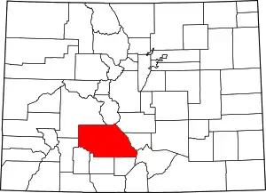 Map of Colorado highlighting Saguache County | |
| Unincorporated communities | ||
| Footnotes | ‡This populated place also has portions in an adjacent county or counties | |
| ||

