Champigny-la-Futelaye
Champigny-la-Futelaye is a commune in the Eure department in northern France.
Champigny-la-Futelaye | |
|---|---|
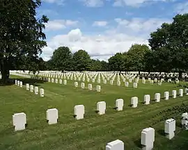 The German war cemetery in Champigny-la-Futelaye | |
Location of Champigny-la-Futelaye 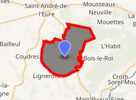
| |
 Champigny-la-Futelaye  Champigny-la-Futelaye | |
| Coordinates: 48°51′53″N 1°17′55″E | |
| Country | France |
| Region | Normandy |
| Department | Eure |
| Arrondissement | Évreux |
| Canton | Saint-André-de-l'Eure |
| Intercommunality | CA Évreux Portes de Normandie |
| Government | |
| • Mayor (2008–2014) | Robin Saulnier |
| Area 1 | 15.98 km2 (6.17 sq mi) |
| Population (2017-01-01)[1] | 289 |
| • Density | 18/km2 (47/sq mi) |
| Time zone | UTC+01:00 (CET) |
| • Summer (DST) | UTC+02:00 (CEST) |
| INSEE/Postal code | 27144 /27220 |
| Elevation | 94–146 m (308–479 ft) (avg. 192 m or 630 ft) |
| 1 French Land Register data, which excludes lakes, ponds, glaciers > 1 km2 (0.386 sq mi or 247 acres) and river estuaries. | |
Population
| Year | Pop. | ±% |
|---|---|---|
| 1962 | 125 | — |
| 1968 | 146 | +16.8% |
| 1975 | 136 | −6.8% |
| 1982 | 163 | +19.9% |
| 1990 | 207 | +27.0% |
| 1999 | 231 | +11.6% |
| 2008 | 233 | +0.9% |
See also
References
- "Populations légales 2017". INSEE. Retrieved 6 January 2020.
| Wikimedia Commons has media related to Champigny-la-Futelaye. |
| Authority control |
|---|
This article is issued from Wikipedia. The text is licensed under Creative Commons - Attribution - Sharealike. Additional terms may apply for the media files.