Charleval, Eure
Charleval is a commune in the Eure department in northern France.
Charleval | |
|---|---|
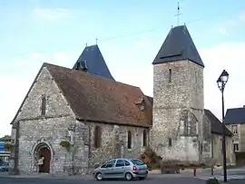 The church in Charleval | |
.svg.png.webp) Coat of arms | |
Location of Charleval 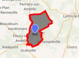
| |
 Charleval  Charleval | |
| Coordinates: 49°22′18″N 1°23′02″E | |
| Country | France |
| Region | Normandy |
| Department | Eure |
| Arrondissement | Les Andelys |
| Canton | Romilly-sur-Andelle |
| Government | |
| • Mayor (2014–2020) | Denis Lebaillif |
| Area 1 | 14.14 km2 (5.46 sq mi) |
| Population (2017-01-01)[1] | 1,789 |
| • Density | 130/km2 (330/sq mi) |
| Time zone | UTC+01:00 (CET) |
| • Summer (DST) | UTC+02:00 (CEST) |
| INSEE/Postal code | 27151 /27380 |
| Elevation | 28–140 m (92–459 ft) (avg. 47 m or 154 ft) |
| 1 French Land Register data, which excludes lakes, ponds, glaciers > 1 km2 (0.386 sq mi or 247 acres) and river estuaries. | |
History
Formerly known as Noyon-sur-Andelle, it was renamed Charleval in honour of King Charles IX.
The Château de Charleval (begun 1570, unfinished, disappeared) was designed by Jacques I Androuet du Cerceau, who engraved his designs and published them in 1579.[2]
_-_Ch%C3%A2teau%252C_Charleval_-_WGA00432.jpg.webp) Court facade
Court facade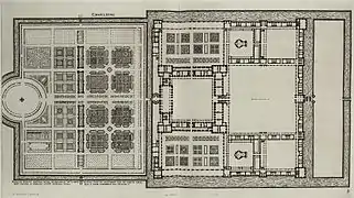 General plan
Population
| Year | Pop. | ±% |
|---|---|---|
| 1793 | 670 | — |
| 1800 | 690 | +3.0% |
| 1806 | 621 | −10.0% |
| 1821 | 725 | +16.7% |
| 1831 | 909 | +25.4% |
| 1836 | 1,013 | +11.4% |
| 1841 | 1,183 | +16.8% |
| 1846 | 1,187 | +0.3% |
| 1851 | 1,316 | +10.9% |
| 1856 | 1,489 | +13.1% |
| 1861 | 1,457 | −2.1% |
| 1866 | 1,445 | −0.8% |
| 1872 | 1,442 | −0.2% |
| 1876 | 1,583 | +9.8% |
| 1881 | 1,618 | +2.2% |
| 1886 | 1,697 | +4.9% |
| 1891 | 1,585 | −6.6% |
| 1896 | 1,712 | +8.0% |
| 1901 | 1,850 | +8.1% |
| 1906 | 2,035 | +10.0% |
| 1911 | 1,745 | −14.3% |
| 1921 | 1,705 | −2.3% |
| 1926 | 1,721 | +0.9% |
| 1931 | 1,813 | +5.3% |
| 1936 | 1,674 | −7.7% |
| 1946 | 1,606 | −4.1% |
| 1954 | 1,667 | +3.8% |
| 1962 | 1,632 | −2.1% |
| 1968 | 1,636 | +0.2% |
| 1975 | 1,654 | +1.1% |
| 1982 | 1,753 | +6.0% |
| 1990 | 1,768 | +0.9% |
| 1999 | 1,872 | +5.9% |
| 2008 | 1,836 | −1.9% |
| 2015 | 1,863 | +1.5% |
See also
References
- "Populations légales 2017". INSEE. Retrieved 6 January 2020.
- Jacques I Androuet du Cerceau, Le second volume des plus excellents Bastiments de France (Paris, 1579; reduced size reprint: Gregg International, 1972, ISBN 9780576154086). See also Commons:Category:Château de Charleval.
| Wikimedia Commons has media related to Charleval (Eure). |
| Authority control |
|---|
This article is issued from Wikipedia. The text is licensed under Creative Commons - Attribution - Sharealike. Additional terms may apply for the media files.