Léry, Eure
Léry is a commune in the Eure department and Normandy region of France.
Léry | |
|---|---|
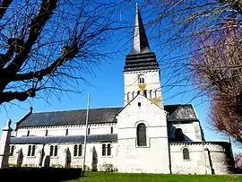 The church of Saint-Ouen in Léry | |
 Coat of arms | |
Location of Léry 
| |
 Léry  Léry | |
| Coordinates: 49°17′10″N 1°12′27″E | |
| Country | France |
| Region | Normandy |
| Department | Eure |
| Arrondissement | Les Andelys |
| Canton | Val-de-Reuil |
| Government | |
| • Mayor (2008–2014) | Robert Ozeel |
| Area 1 | 14.51 km2 (5.60 sq mi) |
| Population (2017-01-01)[1] | 2,033 |
| • Density | 140/km2 (360/sq mi) |
| Time zone | UTC+01:00 (CET) |
| • Summer (DST) | UTC+02:00 (CEST) |
| INSEE/Postal code | 27365 /27690 |
| Elevation | 5–128 m (16–420 ft) (avg. 10 m or 33 ft) |
| 1 French Land Register data, which excludes lakes, ponds, glaciers > 1 km2 (0.386 sq mi or 247 acres) and river estuaries. | |
Population
| Year | Pop. | ±% |
|---|---|---|
| 1962 | 939 | — |
| 1968 | 992 | +5.6% |
| 1975 | 1,015 | +2.3% |
| 1982 | 1,617 | +59.3% |
| 1990 | 1,805 | +11.6% |
| 1999 | 2,139 | +18.5% |
| 2008 | 2,035 | −4.9% |
See also
References
- "Populations légales 2017". INSEE. Retrieved 6 January 2020.
| Wikimedia Commons has media related to Léry (Eure). |
This article is issued from Wikipedia. The text is licensed under Creative Commons - Attribution - Sharealike. Additional terms may apply for the media files.