Morsan
Morsan is a commune in the Eure department in Normandy in northern France. The inhabitants are called Morsanais.
Morsan | |
|---|---|
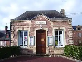 Town hall | |
Location of Morsan 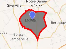
| |
 Morsan  Morsan | |
| Coordinates: 49°10′57″N 0°35′42″E | |
| Country | France |
| Region | Normandy |
| Department | Eure |
| Arrondissement | Bernay |
| Canton | Brionne |
| Government | |
| • Mayor (2008–2014) | Francis Agasse |
| Area 1 | 4.83 km2 (1.86 sq mi) |
| Population (2017-01-01)[1] | 108 |
| • Density | 22/km2 (58/sq mi) |
| Time zone | UTC+01:00 (CET) |
| • Summer (DST) | UTC+02:00 (CEST) |
| INSEE/Postal code | 27418 /27800 |
| Elevation | 155–175 m (509–574 ft) (avg. 172 m or 564 ft) |
| 1 French Land Register data, which excludes lakes, ponds, glaciers > 1 km2 (0.386 sq mi or 247 acres) and river estuaries. | |
History
In medieval times Morsan was also written Morçan, Morsent or Morseng. It belonged to the Bec Abbey until Jean de Morsent 1276 affirmed that he needed his wealth for his followers in times of war.[2]
Chevalier Philémon Lesens (also Le Sens), was the first baron of Morsan. He was nobleman of the Maison du Roi of King Henry IV of France and governor of Bernay.[3] He built a hunting lodge. At the time of Abdon-Thomas-François Lesens (1724–1800), who had been page of Louis XV of France before he became marquis of Morsan,[3] Ange-Jacques Gabriel (1698–1782) redesigned the facade.[4] The hunting lodge is privately owned nowadays.[5]
Morsan got municipal administration in 1789.
In 1871, during the Franco-Prussian War Morsan was garrisoned by the Prussian army. In 1940, during World War II it was garrisoned by the German army.
There are no streetnames in Morsan, the village is divided in districts. The old districts of Morsan were: le Château, la Couranterie, les Jumeaux, la Mourioterie, la Mondière.[2] The center of the village is called Bourg instead of la Mondière today.
Morsan is one of the communes in Eure under the risk of sudden forming of deneholes. In former times the peasants have exploited the marl underground to fertilize the fields. During heavy rain those ancient excavations can open again. These special deneholes are round holes of 1,5–2 meters diameter and several meters deep. There are around 16000 of those holes in the département Eure.[6]
Population
| Year | Pop. | ±% |
|---|---|---|
| 1962 | 119 | — |
| 1968 | 130 | +9.2% |
| 1975 | 130 | +0.0% |
| 1982 | 93 | −28.5% |
| 1990 | 70 | −24.7% |
| 1999 | 92 | +31.4% |
| 2008 | 119 | +29.3% |
 village school
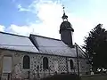 Church de la sainte Trinité in Morsan. Nave was built in the 13th century, sanctuary in the 17th century.[7]
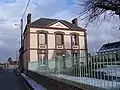
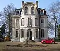 Le Château Blanc, the baroque Lustschloss of Morsan
See also
References
- "Populations légales 2017". INSEE. Retrieved 6 January 2020.
- Le Prevost, Auguste; Léopold Delisle; Louis Paulin Passy; Andrew Dickson White (1864). Mémoires et notes de M. Auguste Le Prevost pour servir à l'histoire du département de l'Eure (in French). Evreux: Société d'agriculture des belles-lettres, sciences et arts de L'Eure. p. 425.
- de Magny, Edouard (1863). [full text on Gallica Nobiliaire de Normandie] Check
|url=value (help) (in French). 2. Paris. pp. 475 et seq. - Brismontier, Bruno (September–October 2008). "Normandy, an original splendor". Propriétés de France. 114. Le Figaro. pp. 32f.
- Miller, Judith (2003). The Style Sourcebook: The Definitive Illustrated Directory of Fabrics, Wallpapers, Paints, Flooring, Tiles. Firefly Books. p. 19. ISBN 978-1-55297-791-0.
- Dossier d'Information Communal des risques majeurs de la commune Morsan Archived 2008-12-05 at the Wayback Machine (french)
- Les Communes de l'Eure et leurs églises (french)
External links
| Wikimedia Commons has media related to Morsan. |
- Morsan on the site of the Prefecture of Eure (French)
- Morsan on Les Communes de France
- Morsan on the annuaire-mairie (French)
| Authority control |
|---|
