Tangtse
Tangtse[2] (Tanktse[3] or Tankse[4])[lower-alpha 1] is a village in the Leh district of Ladakh, India.[5] It is located in the Durbuk tehsil. Traditionally, it was regarded as the border between the Nubra region to the north and the Pangong region to the south. It was a site of wars between Ladakh and Tibet.
Tangtse
Drangtse | |
|---|---|
Village | |
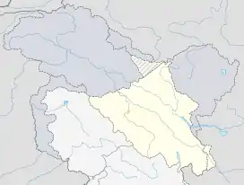 Tangtse Location in Ladakh, India  Tangtse Tangtse (India) | |
| Coordinates: 34.0301500°N 78.1677300°E | |
| Country | India |
| Union Territory | Ladakh |
| District | Leh |
| Tehsil | Durbuk |
| Government | |
| • Councillor | Tashi Namgyal Yakzee[1] |
| Population (2011) | |
| • Total | 681 |
| Time zone | UTC+5:30 (IST) |
| Census code | 874 |
During the Jammu and Kashmir princely rule, Tangtse was the headquarters of an ilaqa (subdistrict), whose territory included the Pangong Lake area, the Chang Chenmo Valley and the Aksai Chin plateau. Tangtse was also a major halting place on the trade route to Yarkand via the Chang Chenmo Valley.
Tangtse is one of the 26 constituencies of the Ladakh Autonomous Hill Development Council of the Leh district. Following the 2020 election, the Councillor for Tangste is Tashi Namgyal Yakzee, who is also in the Executive Council.[1]
Geography
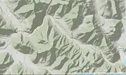
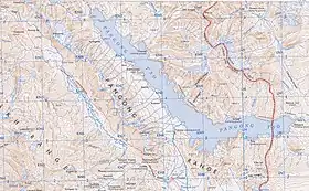
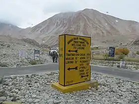
Tangtse is located at the intersection of two major strands of the Karakoram fault system, called the Tangtse fault and the Pangong fault. The two faults sandwich the Pangong Range, at the northern periphery of which lies the village of Tangtse.[12]
The Tangtse fault is home to the Lung or Long valley, divided into three sections: Long Kongma, Long Parma and Long Yogma (the upper, middle and lower sections).[lower-alpha 2] In modern maps, the entire valley is labelled as Loi Yogma without any division into sections. The Tangtse River (or Lung Chu) flows through the valley, draining the western slopes of the Pangong Range as well as the eastern slopes of the Ladakh Range. It flows past Tangtse to join the Shyok River near Durbuk.
The Pangong fault was once home to a "Pangong River" which flowed through this valley during the pleistocene. But the river has since been dammed by tectonic activity and has turned into the Pangong Lake. The valley of the erstwhile effluent of the lake now houses the Mughlib stream, which joins the Tangtse River near the village of Tangtse.[13][14][15] Even though the Ladakhis had no knowledge of the erstwhile "Pangong River" (it having predated the birth of humanity), they preserve a myth that the waters flowing into the Mughlib stream, from a "scanty spring at Wangtong", represent the filtered waters of the Pangong Lake.[16] The Ladakhis thus regard the Tangtse village lying at the northwestern end of the Pangong Lake.[17]
History
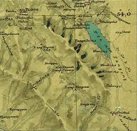
Tangtse lies at the border between the Nubra region (tradidionally called Dumra) and the Pangong region. It played a key role in the two wars between the Ladakhis and Tibetans, the Tibet–Ladakh–Mughal War (1679–1684) and the Dogra–Tibetan War (1841–1842).
Tibet-Ladakh-Mughal War
In 1679, the Tibetan forces under the command of Galdan Chhewang fought an advance guard of Ladakhi forces in Guge (West Tibet). After defeating them, they invaded Ladakh itself. The route taken by the Tibetans is believed to have been via Rudok, Chushul and the Lung Chu valley.[18] The Ladakhis joined the battle at Lung-Khung (Long Kongma) and repulsed the attack.[19][20]
The following year, Tibet sent formidable reinforcements (estimated at 5,000 troops along with several seasoned commanders) and the Tibetans returned. A battle was fought at the "foot of the Chang La pass", which would again indicate the valley between Durbuk and Tangtse. Cunnigham gives the location of the final battle as Balaskya and Petech as dPal-rgyas.[21][22] The Ladakhis were roundly defeated and withdrew to the fort of Basgo in northern Ladakh. After a three-year siege, they requested assistance from the Mughal forces in Kashmir, who fought off the Tibetans and chased them to the Pangong area.[23]
Rudok and Guge, which were previously under the control of Ladakh, slipped out of Ladakhi hands. In 1684, they agreed to respect the new borders in a Treaty of Tingmosgang.
Dogra–Tibetan War
After the defeat of the Zorawar Singh's forces in West Tibet, the Tibetans were incited by Ladakhi rebels, who wanted to overthrow the Dogras ensconced in Ladakh. Apparently to lend support to them, the Tibetan forces marched to Ladakh and camped at "Dumra".[24] The most likely location of this encampment is in the valley between Tangtse and Durbuk. It is reported that Lhasa dispatched an additional 5,000 troops to join them here.[25] The Tibetan accounts say that they established a defence post was at "Lung-wu" (Long Yogma),[26] described as a place between "Rudok and the Pangong Lake".[27][28][lower-alpha 3]
The Ladakhi rebels had declared their minor king Jigmet Senge Namgyal as an independent ruler, who wrote to the Sikh emperor Sher Singh stating that he had submitted to the Chinese emperor and offered truce terms.[30] No response was received. After the arrival of the reinforcements, led by Dewan Hari Chand and Wazir Ratanu, the Dogras challenged the Tibetan encampments at Tangtse and the Loi Yogma valley. Skirmishes continued for several days with a loss of 300 men for the Dogras. Eventually, the Dogras employed a decisive flooding tactic, following a suggestion from a Nubra chieftain, which dislodged the Tibetans from their trenches and led to a Dogra victory.[31]
Afterwards a 'Treaty of Chushul' was agreed by the two sides, restoring the status quo ante bellum. The Ladakhi ruler was granted privileges appropriate to his rank, and trade and diplomatic missions were restored to their traditional operation..
Tankse ilaqa

During the Dogra rule, Tankse was the headquarters of a subdistrict (a kardari, often called an ilaqa), which controlled access to the Chang Chenmo Valley. Phobrang, Chushul, and Durbuk were under its control.[32]
The Chang Chenmo route to Central Asia passed through Tankse, which the British attempted to promote as the main trade route between Leh and Yarkand in the late 19th century. Tankse was described as a large village with 50 houses. It had a rest house and a government supply depot. Travellers were advised to procure their supplies here, to sustain themselves till reaching Sanju, about 350 miles away.[32]
With the eruption of the Sino-Indian border dispute in the late 1950s, the Indian government had ample documents from the time of Dogra administration to demonstrate that the Chang Chenmo Valley and the Aksai Chin plateau belonged to Ladakh.[33] The Kashmir state records classified these regions as part of the Tankse ilaqa and revenue records were available with regular assessments and settlements of revenue. The revenue maps showed the large stretches of uninhabited territories, which are now occupied by China, as part of the Tankse ilaqa.[34]
Rock Art
Tangtse is a well-known and important site of Tocharian, Sogdian, Śārāda and Arabic inscriptions.[35][36] A Franco-Indian Archaeological Mission in Ladakh called the rock art at Tangste as "the most important" site for rock art in Ladakh, providing information about Ladakh towards the end of the 1st millennium AD.[36] The mission found "about 300 petroglyphs" and "almost 70 rock inscriptions in various scripts".[36] Some authors classify some of the signs here as tamgas.[37] Volutes can be seen on some of the inscriptions of animals.[38] Compositions from Ruthok and Tangtse are noted to be similar.[39]
Demographics
According to the 2011 census of India, Tangtse has 126 households. The effective literacy rate (i.e. the literacy rate of population excluding children aged 6 and below) is 69.93%.[6]
| Total | Male | Female | |
|---|---|---|---|
| Population | 681 | 356 | 325 |
| Children aged below 6 years | 79 | 45 | 34 |
| Scheduled caste | 0 | 0 | 0 |
| Scheduled tribe | 679 | 355 | 324 |
| Literates | 421 | 261 | 160 |
| Workers (all) | 400 | 198 | 202 |
| Main workers (total) | 191 | 123 | 68 |
| Main workers: Cultivators | 73 | 40 | 33 |
| Main workers: Agricultural labourers | 2 | 2 | 0 |
| Main workers: Household industry workers | 5 | 3 | 2 |
| Main workers: Other | 111 | 78 | 33 |
| Marginal workers (total) | 209 | 75 | 134 |
| Marginal workers: Cultivators | 176 | 55 | 121 |
| Marginal workers: Agricultural labourers | 0 | 0 | 0 |
| Marginal workers: Household industry workers | 1 | 0 | 1 |
| Marginal workers: Others | 32 | 20 | 12 |
| Non-workers | 281 | 158 | 123 |
Infrastructure
A solar power plant in Tangtse provides electricity for five hours every day to about 350 households. Previously, a government diesel generator provided electricity.[40] The area has cellular network connectivity.[41] The Indian Army also has renewable energy infrastructure here including a wind farm.[42][43] Ground water resources have also been developed here with the help of Indian geologist Ritesh Arya.[44]
Notes
- Alternative spellings include Tangtsi,[5] Tagste,[6] and Trangste.[7] Drangtse,[8][9] Bran-rtse[10] and Btang-rtse/Thang-rtse[11] appear to be older spellings.
- See Strachey, Physical Geography of Western Tibet (1854), p. 26 for the terminology of valleys. Moorcroft & Trebeck, Travels in the Himalayan Provinces, Vol. 1 (1841), pp. 445–448 contains a description of the valley.
- It would appear that the "Rudok" stood for its frontier, somewhere near the Spanggur Gap,[29] and "Pangong Lake" stood for Tangtse, with the Loi Yogma valley in between.
References
- "Ladakh Autonomous Hill Development Council, Leh (Executive Council and Councillors)". Union Territory of Ladakh, Government of India. Retrieved 10 December 2020.
- Cunningham, Ladak (1854), p. 272; Phartiyal, Singh & Nag, Trans- and Tethyan Himalayan Rivers, 2017, pp. 375–376
- Drew, The Jummoo and Kashmir Territories (1875), pp. 327–328; Fisher, Rose & Huttenback, Himalayan Battleground (1963), p. 109
- Gazetteer of Kashmir and Ladak (1890), p. 810; Fisher, Rose & Huttenback, Himalayan Battleground (1963), p. 33, footnote
- "Blockwise Village Amenity Directory" (PDF). Ladakh Autonomous Hill Development Council. Archived from the original (PDF) on 9 September 2016. Retrieved 23 July 2015.
- "Leh district census". 2011 Census of India. Directorate of Census Operations. Retrieved 23 July 2015.
- Bruneau & Bellezza 2013, p. 23.
- Charak, General Zorawar Singh (1983), pp. 104–105.
- Handa, Buddhist Western Himalaya (2001), p. 204.
- Fisher, Rose & Huttenback, Himalayan Battleground (1963), p. 33.
- Bruneau & Bellezza 2013, p. 21.
- Dortch et al, Catastrophic partial drainage of Pangong Tso, 2011, p. 111.
- Cunningham, Ladak (1854), pp. 136–137: "In former ages there can be no doubt that the Pangkong Lake had an outlet at its north-western extremity, through a gorge in the limestone cliffs, into the present scanty stream that passes by Muglib [Mughlib], and joins the Shayok river just above the village, which gives its name to the stream. At some remote period, therefore, the waters of the Pangkong Lake must have been fresh; a fact which has been placed beyond all doubt by Captain H. Strachey's discovery of fossil shells of the Lymnaea auricularia in the ancient clay deposits above the present level of the lake."
- Dortch et al, Catastrophic partial drainage of Pangong Tso, 2011, p. 111: "Pangong Tso is in a closed basin (Shi et al., 2001), but it fed the Tangtse River during the Pleistocene. The Tangtse River now receives most of its waters from melting glaciers on the northern side of the Pangong Range and waters from the Loi Yogma valley."
- Searle, Colliding Continents (2013): "The lake had been formed when a series of large earthquakes had dammed the Pangong River. In one small sector successive earthquakes had resulted in an uplifted segment of the valley and forced the river to flow in the opposite direction for a small distance. The Pangong Tso was dammed and then filled up, since it had no outlet. Spectacular outcrops of gneisses, mylonites, and a series of leucogranite dykes were beautifully exposed along the valley walls."
- Strachey, Physical Geography of Western Tibet (1854), pp. 46–47: "... the first appearance of the Muglib rivulet in a scanty spring at Wangtong, being 7 or 8 miles; and the spring, being sub-saline, is considered by the Tibetan inhabitants as a filtration of the lake water."
- Charak, General Zorawar Singh (1983), pp. 104–105: "After withdrawing from Leh and other strongholds, the Tibetans and their Ladakhi accomplices gathered under General Pi-hsi at Drangtse near the western end of the Pangkong lake... "
- Emmer, Gerhard (2007), "Dga' Ldan Tshe Dbang Dpal Bzang Po and the Tibet-Ladakh-Mughal War of 1679-84", Proceedings of the Tenth Seminar of the IATS, 2003. Volume 9: The Mongolia–Tibet Interface: Opening New Research Terrains in Inner Asia, BRILL, pp. 95–96, ISBN 978-90-474-2171-9: "He [Galdan Chewang] turned north to Ruthog, went around the shores of the Pangong mtsho and tried to reach the Indus valley from there."
- Cunningham, Ladak (1854), pp. 326–327.
- Petech, The Tibetan-Ladakhi Moghul War (1947), pp. 178–179.
- Emmer, the Tibet-Ladakh-Mughal War (2007), p. 96.
- Petech, The Tibetan-Ladakhi Moghul War (1947), p. 180.
- Rahul, Ram (2000), March of Central Asia, Indus Publishing, p. 51, ISBN 978-81-7387-109-2
- Shakabpa, One Hundred Thousand Moons (2009), pp. 583–584: "The Tibetan soldiers pursued the remaining troops as far as a place called Dumra, just one day’s journey from Leh, where the Tibetan army pitched their camp."
- Charak, General Zorawar Singh (1983): "After withdrawing from Leh and other strongholds, the Tibetans and their Ladakhi accomplices gathered under General Pi-hsi at Drangtse near the western end of the Pangkong lake and there they were joined by a Tibetan army of 5,000 men under the command of Ragasha and Zarkhang. They dug out trenches and erected a fortified camp there in six days. The Dogra accounts give their number as 6,000 men, led by Bakshi Chhak Jot, Ragasha Kahion and Raz Chak Garpon, aided by a big cannon which they had wrested from Zorawar Singh."
- Fisher, Rose & Huttenback, Himalayan Battleground (1963), p. 172, footnote.
- Charak, General Zorawar Singh (1983), p. 105: "The Tibetan defence post was set up at Lung-wu, a place between Rudok and the Pangkong lake, on the Tibetan frontier. The camp was located at a strategic, lower part of a narrow valley, and the storming of it would have meant a considerable loss to the Dogras."
- Fisher, Rose & Huttenback, Himalayan Battleground (1963), p. 172. Quoting from the report of the Chinese Amban: "A defense post was then set up at Lung-wu, a place on the Tibetan frontier. On the 27th day of the 7th month [September 2, 1842], Pa-chan, the Shen-pa officer, led the barbarians in a frontal assault upon the Lung-wu camp."
- Moorcroft & Trebeck, Travels in the Himalayan Provinces, Vol. 1 (1841), pp. 360–361.
- Handa, Buddhist Western Himalaya (2001), p. 203: "The Ladakhis approached the Tibetan commander-in-chief Peshi Shata for help, who joined them with his 3000 troops. The combined Tibeto-Ladakhi force entered Leh and declared the minor King Jigmet Senge Namgyel as the independent ruler of Ladakh."
- Handa, Buddhist Western Himalaya (2001), p. 204: "Well-equipped 6000 strong, they moved on to Drangtse, where they entrenched themselves in a strategic stronghold at Long-Yogma. For days light skirmishes continued that killed 300 Dogra men and left many more wounded. At last Thangpa Joldan (Sonam), a resident of Nubra, suggested Diwan Hari Chand that if the nearby canal could be dammed and the impounded water released to flood the enemy entrenchment, their courage and ammunition, both could be dampened. The plan was implemented and the result was instantaneous and decisive. The enemy surrendered."
- Gazetteer of Kashmir and Ladak (1890), p. 810.
- Fisher, Rose & Huttenback, Himalayan Battleground (1963), p. 109: "The Indian report stated that the inhabitants of Tanktse district had used the pasture lands of the Chang Chenmo valley as far as the Lanak Pass for grazing their goats and sheep as well as those further south above Pangong Lake."
- Fisher, Rose & Huttenback, Himalayan Battleground (1963), p. 118
- Bruneau & Bellezza 2013, p. 21, 30.
- Cultural Heritage of Ladakh. Rock Art Sites. Tangste 2016. via — MAFIL (Mission Archéologique Franco-Indienne au Ladakh or Franco-Indian Archaeological Mission in Ladakh)
- Bruneau & Bellezza 2013, p. 31.
- Bruneau & Bellezza 2013, p. 47.
- Bruneau & Bellezza 2013, p. 51.
- "Integrated Development of Durbuk Block Using Renewable Energy Resources". Ladakh Ecological Development and Environmental Group (LEDeG). 17 September 2019. Retrieved 10 December 2020.
- "Ladakh: World famous Tourism spot Pangong Tso route gets 4G services at Tangtse". News Services Division. All India Radio. 9 November 2020. Retrieved 10 December 2020.
- Dutt, Sanjay (15 August 2020). "Solar energy to power Siachen Base Camp, Brigade headquarters". The Times of India. Retrieved 10 December 2020.
- Prasad, Nithin Thomas (29 September 2020). "Military Engineer Services Announces Tender for 3 MW of Solar Projects in Leh". Mercom India. Retrieved 10 December 2020.
- Sawant, Gaurav C. (16 September 2020). "Ladakh conflict: Indian army's hunt for water at DBO and hope to revive a 10,000-year-old lake". India Today. Retrieved 10 December 2020.
Bibliography
- Gazetteer of Kashmir and Ladak, Calcutta: Superintendent of Government Printing, 1890
- Charak, Sukhdev Singh (1983), General Zorawar Singh, Publications Division, Government of India – via archive.org
- Cunningham, Alexander (1854), Ladak: Physical, Statistical, Historical, London: Wm. H. Allen and Co – via archive.org
- Dortch, Jason M.; Owen, Lewis A.; Caffee, Marc W.; Kamp, Ulrich (2011). "Catastrophic partial drainage of Pangong Tso, northern India and Tibet". Geomorphology. 125 (1): 109–121. Bibcode:2011Geomo.125..109D. doi:10.1016/j.geomorph.2010.08.017. ISSN 0169-555X.
- Drew, Frederic (1873), "Alluvial and Lacustrine Deposits and Glacial Records of the Upper-Indus Basin", Quarterly Journal of the Geological Society of London: 441–471
- Drew, Frederic (1875), The Jummoo and Kashmir Territories: A Geographical Account, E. Stanford – via archive.org
- Fisher, Margaret W.; Rose, Leo E.; Huttenback, Robert A. (1963), Himalayan Battleground: Sino-Indian Rivalry in Ladakh, Praeger – via archive.org
- Handa, O. C.; Hāṇḍā, Omacanda (2001), Buddhist Western Himalaya: A politico-religious history, Indus Publishing, ISBN 978-81-7387-124-5
- Petech, Luciano (September 1947), "The Tibetan-Ladakhi Moghul War of 1681-83", The Indian Historical Quarterly, 23 (3): 169– – via archive.org
- Phartiyal, Binita; Singh, Randheer; Nag, Debarati (2017), "Trans- and Tethyan Himalayan Rivers: In Reference to Ladakh and Lahaul-Spiti, NW Himalaya", in Dhruv Sen Singh (ed.), The Indian Rivers: Scientific and Socio-economic Aspects, Springer, pp. 367–382, ISBN 978-981-10-2984-4
- Searle, Mike (2013), Colliding Continents: A geological exploration of the Himalaya, Karakoram, and Tibet, Oxford University press, ISBN 978-0-19-165249-3
- Strachey, Henry (1854), Physical Geography of Western Tibet, London: William Clows and Sons – via archive.org
- Bruneau, Laurianne; Bellezza, John Vincent (December 2013). "Inner Asian cultural adaptation, regional differentiation and the 'Western Tibetan Plateau'" (PDF). Revue d'Études Tibétaines. 28: 5–161.