Fiang
Fiang (also known as Phyang) is a village in Leh district of Ladakh in India.[1] It is in the Leh tehsil. The Phyang Monastery is in this village. This is one of the largest inhabited villages of Ladakh, comprising eight clusters: Phulungs, Phyang, Tsakma, Changmachan, Gaon, Thangnak, Chusgo and Mankhang. It is in a south-facing valley in the Ladakh Range of mountains. The village is about 15 km (9.3 mi) long and 1.5 km (0.93 mi) average width. There is an old dilapidated castle near the cluster of Phyang on a hilltop. Just below this castle, there is a single-room temple, Lobon, with paintings of Ladakh, but in the tourism industry, it is known as Guru Lhakhang. The Tokpo river is in the middle of the valley. The source of the river is small glaciers in upper Spangkul and Lungnak valley northwest of the village at an altitude of about 5,200 m (17,100 ft). The river joins the Indus River near Phey village at a lower altitude of 3,250 m (10,660 ft). The village has some tourist facilities, including a guesthouse and campsites. Hidden North guesthouse is just opposite the site of Guru Lhakhang at Tsakma cluster.
Fiang
Phyang | |
|---|---|
Village | |
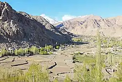 View from Phyang Monastery | |
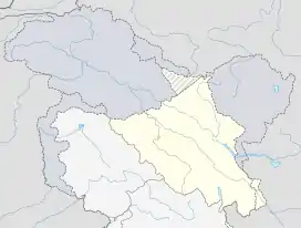 Fiang Location in Ladakh, India  Fiang Fiang (India) | |
| Coordinates: 34.189399°N 77.489076°E | |
| Country | India |
| Union Territory | Ladakh |
| District | Leh |
| Tehsil | Leh |
| Population (2011) | |
| • Total | 2,036 |
| Time zone | UTC+5:30 (IST) |
| Census code | 855 |
Demographics
According to the 2011 census of India, Fiang has 352 households. The effective literacy rate (i.e. the literacy rate of population excluding children aged 6 and below) is 75.37%.[2]
| Total | Male | Female | |
|---|---|---|---|
| Population | 2036 | 1064 | 972 |
| Children aged below 6 years | 229 | 124 | 105 |
| Scheduled caste | 0 | 0 | 0 |
| Scheduled tribe | 1998 | 1043 | 955 |
| Literates | 1362 | 789 | 573 |
| Workers (all) | 713 | 439 | 274 |
| Main workers (total) | 536 | 348 | 188 |
| Main workers: Cultivators | 185 | 91 | 94 |
| Main workers: Agricultural labourers | 2 | 1 | 1 |
| Main workers: Household industry workers | 0 | 0 | 0 |
| Main workers: Other | 349 | 256 | 93 |
| Marginal workers (total) | 177 | 91 | 86 |
| Marginal workers: Cultivators | 121 | 50 | 71 |
| Marginal workers: Agricultural labourers | 6 | 4 | 2 |
| Marginal workers: Household industry workers | 2 | 2 | 0 |
| Marginal workers: Others | 48 | 35 | 13 |
| Non-workers | 1323 | 625 | 698 |
References
- "Blockwise Village Amenity Directory" (PDF). Ladakh Autonomous Hill Development Council. Retrieved 23 July 2015.
- "Leh district census". 2011 Census of India. Directorate of Census Operations. Retrieved 23 July 2015.
| History |
| ||||||||||||||||||
|---|---|---|---|---|---|---|---|---|---|---|---|---|---|---|---|---|---|---|---|
| Administration | |||||||||||||||||||
| Geography |
| ||||||||||||||||||
| Human settlements | |||||||||||||||||||
| Culture |
| ||||||||||||||||||
| Tourism and wildlife |
| ||||||||||||||||||
| Transport |
| ||||||||||||||||||
| Infrastructure |
| ||||||||||||||||||
| See also |
| ||||||||||||||||||
