Fitzgibbon, Queensland
Fitzgibbon is a northern suburb of the City of Brisbane, Queensland, Australia.[3] In the 2016 census, Fitzgibbon had a population of 5,656 people.[1]
| Fitzgibbon Brisbane, Queensland | |||||||||||||||
|---|---|---|---|---|---|---|---|---|---|---|---|---|---|---|---|
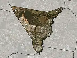
 Satellite imagery of Fitzgibbon with suburb boundary shown | |||||||||||||||
 Fitzgibbon | |||||||||||||||
| Coordinates | 27.34°S 153.0344°E | ||||||||||||||
| Population | 5,656 (2016 census)[1] | ||||||||||||||
| • Density | 1,825/km2 (4,730/sq mi) | ||||||||||||||
| Postcode(s) | 4018 | ||||||||||||||
| Area | 3.1 km2 (1.2 sq mi) | ||||||||||||||
| Time zone | AEST (UTC+10:00) | ||||||||||||||
| Location | 15.6 km (10 mi) N of Brisbane CBD | ||||||||||||||
| LGA(s) | City of Brisbane (Bracken Ridge Ward)[2] | ||||||||||||||
| State electorate(s) | Sandgate | ||||||||||||||
| Federal Division(s) | Petrie | ||||||||||||||
| |||||||||||||||
Geography
The suburb is one of the smallest suburbs in Brisbane. The suburb is roughly triangular in shape, and is bounded by the North Coast railway, Cabbage Tree Creek, and Telegraph Road.[4] It was subdivided for residential use in the 1980s and 1990s.[4]
History
The suburb was named after Abram Fitzgibbon, who was chief engineer of railways in Queensland in the 1860s.[3][5]
The area was previously the site of a council landfill. The landfill was first opened on the 1st of December 1981, and was located on Telegraph Road (now the Bill Brown Sports Reserve). On the 14th of January 1985, the site was closed and moved further south to Roghan Road (now the site of the Hidden World playground). It operated until the 30th of September 1995. [6]
In the 2016 census, Fitzgibbon had a population of 5,656 people.[1]
Education
There are no schools in Fitzgibbon. The nearest primary schools are in neighborouging Taigum and Bracken Ridge. The nearest secondary schools are Sandgate District State High School in neighbouring Deagon and Aspley State High School in Aspley.[7]
A new Catholic secondary school is expected to open in 2022 initially offering Year 7 schooling.[8]
Demographics
In the 2016 census, Fitzgibbon recorded a population of 5,656 people, 52.4% female and 47.6% male.
The median age of the Fitzgibbon population was 33 years of age, 5 years below the Australian median.
54.9% of people living in Fitzgibbon were born in Australia, compared to the national average of 66.7%; the next most common countries of birth were India 9.6%, New Zealand 5.0%, Philippines 4.4%, England 2.8%, China 2.1%.
61.0% of people spoke only English at home; the next most popular languages were 3.5% Punjabi, 2.7% Hindi, 2.2% Tagalog, 2.2% Cantonese, 2.1% Mandarin.
References
- Australian Bureau of Statistics (27 June 2017). "Fitzgibbon (SSC)". 2016 Census QuickStats. Retrieved 20 October 2018.

- "Bracken Ridge Ward". Brisbane City Council. Brisbane City Council. Archived from the original on 4 February 2017. Retrieved 12 March 2017.
- "Fitzgibbon – suburb in City of Brisbane (entry 42576)". Queensland Place Names. Queensland Government. Retrieved 25 January 2020.
- "Fitzgibbon". Brisbites. Archived from the original on 20 July 2008. Retrieved 4 March 2007.
- "History of Fitzgibbon". Our Brisbane. Archived from the original on 30 September 2007. Retrieved 4 March 2007.
- "Fitzgibbon dump a time bomb". Gympie Times. Retrieved 14 January 2021.
- "Queensland Globe". State of Queensland. Retrieved 14 March 2020.
- "New Schools". Brisbane Catholic Education. Archived from the original on 4 December 2019. Retrieved 4 December 2019.
External links
| Wikimedia Commons has media related to Fitzgibbon, Queensland. |
- "Fitzgibbon". Queensland Places. University of Queensland.
- "Fitzgibbon". BRISbites. Brisbane City Council. Archived from the original on 20 July 2008.
- "Fitzgibbon". Our Brisbane. Brisbane City Council. Archived from the original on 12 February 2008.