Mackenzie, Queensland
Mackenzie is a south-eastern suburb in the City of Brisbane, Queensland, Australia.[3][4]
| Mackenzie Brisbane City, Queensland | |||||||||||||||
|---|---|---|---|---|---|---|---|---|---|---|---|---|---|---|---|
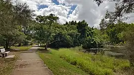 Mount Petrie Road Park, 2018 | |||||||||||||||
| Population | 2,094 (2016 census)[1] | ||||||||||||||
| • Density | 271.9/km2 (704/sq mi) | ||||||||||||||
| Postcode(s) | 4156 | ||||||||||||||
| Area | 7.7 km2 (3.0 sq mi) | ||||||||||||||
| Location | 20 km (12 mi) from Brisbane | ||||||||||||||
| LGA(s) | City of Brisbane (Chandler Ward)[2] | ||||||||||||||
| State electorate(s) | Mansfield | ||||||||||||||
| Federal Division(s) | Bonner | ||||||||||||||
| |||||||||||||||
Geography
The area is partially covered by undeveloped bushland. Mount Petrie is located in Mackenzie.[5]
History
Mount Petrie State School opened on 31 March 1955. Mount Gravatt Special School opened on 17 May 1971. On 21 September 2012 the two schools were amalgamated into Mackenzie State Primary and Special School.[6]
In the 2011 census, Mackenzie had a population of 1,844 people.[7]
Facilities
There are two churches,[8] one school, Mackenzie State School and a single petrol station located in Mackenzie. A number of residential estates with hundreds of new houses have been built in this suburb in the last decade. This is a suburb containing no large or small shopping centres. There has been a recent addition of a fitness station near the park.
Transport
It takes 20–25 minutes to drive the 20 kilometres (12 mi) to the Brisbane CBD via the South East Freeway (off-peak).[5] Neighbouring suburbs include Belmont, Carindale, Mansfield, Rochedale, Upper Mount Gravatt, Wishart, Burbank and Chandler. Major roads such as Mount Gravatt - Capalaba Road and Gateway Motorway run through Mackenzie.
Mt Gravatt Bus services around Mackenzie, buses can access to Queen Elizabeth II Hospital, Garden City and City.
On the day of the 2011 census, 11.5% of employed people travelled to work on public transport and 70.0% by car (either as driver or as passenger).
Demographics
In the 2011 census the population of Mackenzie was 1,844: 50.5% female and 49.5% male.[7]
The median age of the Mackenzie population was 36 years of age, 1 year below the Australian median.
71.4% of people living in Mackenzie were born in Australia, compared to the national average of 69.8%; the next most common countries of birth were England 3.1%, New Zealand 3.1%, South Africa 2.8%, Sri Lanka 1.5%, Hong Kong 1.1%. 79.5% of people spoke only English at home; the next most popular languages were 2.6% Cantonese, 2.3% Greek, 1.4% Sinhalese, 1.3% Afrikaans, 1% Serbian.
See also
References
- Australian Bureau of Statistics (27 June 2017). "Mackenzie (Brisbane - Qld) (State Suburb)". 2016 Census QuickStats. Retrieved 14 April 2018.

- "Chandler Ward". Brisbane City Council. Brisbane City Council. Retrieved 12 March 2017.
- "Mackenzie – City of Brisbane (entry 48443)". Queensland Place Names. Queensland Government. Retrieved 11 October 2015.
- "Welcome to Mackenzie Queensland 4156". yoursuburb.com.au. Archived from the original on 12 February 2008. Retrieved 13 April 2008.
- "History of Mackenzie". OurBrisbane. Archived from the original on 18 February 2004. Retrieved 13 April 2008.
- "Opening and closing dates of Queensland Schools". Queensland Government. Retrieved 11 October 2015.
- Australian Bureau of Statistics (31 October 2012). "Mackenzie". 2011 Census QuickStats. Retrieved 11 October 2015.
- "Wedding Venues - Churches". weddingqld.com. Retrieved 13 April 2008. Note: Two churches located in Mackenzie.
External links
| Wikimedia Commons has media related to Mackenzie, Queensland. |