Brookfield, Queensland
Brookfield is a semi-rural suburb in the City of Brisbane, Queensland, Australia.[3] In the 2016 census, Brookfield had a population of 3,524 people.[1]
| Brookfield Brisbane, Queensland | |||||||||||||||
|---|---|---|---|---|---|---|---|---|---|---|---|---|---|---|---|
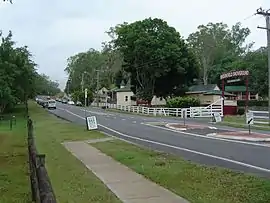 Brookfield Road, 2012 | |||||||||||||||
 Brookfield | |||||||||||||||
| Coordinates | 27.4902°S 152.8958°E | ||||||||||||||
| Population | 3,524 (2016 census)[1] | ||||||||||||||
| • Density | 164.7/km2 (426.5/sq mi) | ||||||||||||||
| Postcode(s) | 4069 | ||||||||||||||
| Area | 21.4 km2 (8.3 sq mi) | ||||||||||||||
| Time zone | AEST (UTC+10:00) | ||||||||||||||
| Location |
| ||||||||||||||
| LGA(s) | City of Brisbane (Pullenvale Ward)[2] | ||||||||||||||
| State electorate(s) | Moggill | ||||||||||||||
| Federal Division(s) | Ryan | ||||||||||||||
| |||||||||||||||
Geography
Brookfield is located approximately 13 kilometres (8.1 mi) west of the Brisbane CBD. Brookfield lies approximately 3 kilometres (1.9 mi) north of the Brisbane River. Moggill Creek flows through Brookfield and joins the Brisbane River at Kenmore.
Brookfield is a semi-rural suburb consisting primarily of acreage properties. Although there are a small number of farms, the vast majority of property is residential.
Moggill Road passes through the southernmost tip of the suburb and Moggill Creek marks part of the suburb's eastern boundary. North of Brookfield are the forested hills and mountains in D'Aguilar National Park.
The centre of Brookfield is on the intersection of Brookfield Road and Boscombe Road. The Brookfield General Store, Brookfield Public Hall, Brookfield Showground, Brookfield Cemetery, Brookfield Recreation Reserve, the Anglican church and the school are all in this area.[4] The Brookfield Horse & Pony Club operates out of the showgrounds.
History
Brookfield is believed to be named by Lucinda Brimblecombe (née Logan) due to course of Moggil Creek through the area.[5]
Brisbane was occupied by the Turrbal Aboriginal group.
Development in the Brookfield area began in 1869, when the area was opened for logging and farming.
Brookfield State School opened on 27 Mar 1871.[6] In 1874 a teacher's residence was built for the school.[7]
Brookfield Post Office opened on 12 August 1876.
Brookfield Cemetery was opened in 1882.
In October 1892 the Anglican parish of Indoorpilly purchased land for a church on the north-east corner of Brookfield Road and Boscombe Road for £20 from the owner, William Thomas Gee. The Anglican Church of the Good Shepherd cost £220 to build and was consecrated on Easter Monday 2 April 1893 by Anglican Bishop of Brisbane, William Webber.[8][9][10]
The first Brookfield Show was held in 1910.
The town hall was moved from Darra to Brookfield in 1931.
In 1932, the school teacher's residence was too small for a teacher with nine children, so a new building was constructed. The old building was bought by the Brookfield Hall trustees and relocated it where it became the Brookfield General Store.[7]
In 1957 Rita O'Hanlan offered riding lessons at the showgrounds, which evolved into the Brookfield Horse and Pony Club.[11]
Heritage listings
Brookfield has a number of heritage-listed sites, including:
- 550 Brookfield Road: Brookfield Public Hall & Showgrounds[12]
- 615 Brookfield Road: Anglican Church of the Good Shepherd[13]
Attractions
Every year the Brookfield Show is held over three days. The 2006 Brookfield show attracted almost 22,000 visitors. A formal ball is held annually in Brookfield. The 2005 Show Ball had 550 attendees, 2006, 2007 and 2008 attracted 800 people.
Education
Brookfield State School is a government primary (Prep-6) school for boys and girls at 36 Boscombe Road (27.4951°S 152.9135°E).[14][15] In 2017, the school had an enrolment of 506 students with 43 teachers (33 full-time equivalent) and 18 non-teaching staff (13 full-time equivalent).[16] It includes a special education program.[14]
There are no secondary schools in Brookfield. The nearest secondary schools are in neighbouring Kenmore.[17]
Demographics
In the 2016 census, Brookfield recorded a population of 3,524 people. The median age of the Brookfield population was 46 years of age, 8 years above the Australian median. 68.3% of people were born in Australia., compared to the national average of 66.7%; were England 6.7% and South Africa 4.5%. 85.5% of people spoke only English at home. The most common responses for religion were No Religion 26.7%, Catholic 21.5% and Anglican 19.1%.[18]
Community groups
The Brookfield branch of the Queensland Country Women's Association meets at Uniting Church Hall on Rafting Ground Road.[19]
References
- Australian Bureau of Statistics (27 June 2017). "Brookfield (SSC)". 2016 Census QuickStats. Retrieved 20 October 2018.

- "Pullenvale Ward". Brisbane City Council. Brisbane City Council. Retrieved 12 March 2017.
- "Brookfield – suburb in City of Brisbane (entry 49693)". Queensland Place Names. Queensland Government. Retrieved 10 June 2019.
- Google (18 August 2019). "Centre of Brookfield" (Map). Google Maps. Google. Retrieved 18 August 2019.
- "Brookfield (entry 48305)". Queensland Place Names. Queensland Government. Retrieved 22 September 2015.
- Queensland Family History Society (2010), Queensland schools past and present (Version 1.01 ed.), Queensland Family History Society, ISBN 978-1-921171-26-0
- "History". Brookfield General Store. Retrieved 18 August 2019.
- "Anglican Church of the Good Shepherd (entry 601263)". Queensland Heritage Register. Queensland Heritage Council. Retrieved 1 August 2014.
- Druve, Merilyn J. (Merilyn Joan); Church of the Good Shepherd (Brookfield, Qld.) (1993), Church of the Good Shepherd, 1893-1993, Brookfield, The Church, ISBN 978-0-646-13552-6
- "Church at Brookfield". The Telegraph (6, 385). Queensland, Australia. 5 April 1893. p. 6. Retrieved 18 August 2019 – via National Library of Australia.
- "Club History". Brookfield Horse and Pony Club. Retrieved 18 August 2019.
- "Brookfield Public Hall & Showgrounds". Brisbane Heritage Register. Brisbane City Council. Retrieved 24 February 2016.
- "Anglican Church of the Good Shepherd (entry 601263)". Queensland Heritage Register. Queensland Heritage Council. Retrieved 19 June 2013.
- "State and non-state school details". Queensland Government. 9 July 2018. Archived from the original on 21 November 2018. Retrieved 21 November 2018.
- "Brookfield State School". Retrieved 21 November 2018.
- "ACARA School Profile 2017". Archived from the original on 22 November 2018. Retrieved 22 November 2018.
- "Queensland Globe". State of Queensland. Retrieved 17 August 2019.
- Australian Bureau of Statistics (27 June 2017). "Brookfield (Qld) (State Suburb)". 2016 Census QuickStats. Retrieved 13 April 2018.
- "Branch Locations". Queensland Country Women's Association. Archived from the original on 26 December 2018. Retrieved 26 December 2018.
External links
| Wikimedia Commons has media related to Brookfield, Queensland. |
- Brookfield and Upper Brookfield: Queensland Places
- "Brookfield". BRISbites. Brisbane City Council. Archived from the original on 19 July 2008.
- "Brookfield". Our Brisbane. Brisbane City Council. Archived from the original on 6 March 2008.