Wynnum West, Queensland
Wynnum West is an outer eastern suburb in the City of Brisbane, Queensland, Australia.[3] In the 2016 census, Wynnum West had a population of 12,292 people.[1]
| Wynnum West Brisbane, Queensland | |||||||||||||||
|---|---|---|---|---|---|---|---|---|---|---|---|---|---|---|---|
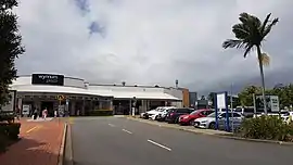 Wynnum Plaza, 2018 | |||||||||||||||
 Wynnum West | |||||||||||||||
| Coordinates | 27.4497°S 153.1538°E | ||||||||||||||
| Population | 12,292 (2016 census)[1] | ||||||||||||||
| • Density | 2,119/km2 (5,490/sq mi) | ||||||||||||||
| Postcode(s) | 4178 | ||||||||||||||
| Area | 5.8 km2 (2.2 sq mi) | ||||||||||||||
| Time zone | AEST (UTC+10:00) | ||||||||||||||
| Location | 17.7 km (11 mi) E of Brisbane GPO | ||||||||||||||
| LGA(s) | City of Brisbane (Wynnum Manly Ward)[2] | ||||||||||||||
| State electorate(s) | Lytton | ||||||||||||||
| Federal Division(s) | Bonner | ||||||||||||||
| |||||||||||||||
Geography
Wynnum West is located 17.7 kilometres (11.0 mi) by road east of the Brisbane GPO.[4]
Lindum is a neighbourhood (27.45°S 153.15°E) in the suburb, named on 16 August 1975 taking its name from the residence of ironmonger Edward Kelk (1850-1921), which is the Roman name for Lincoln, England.[5][6]
Bomparpin Swamp is a wetland (27.4461°S 153.1462°E).[7]
History
A large Jagera and Quandamooka campsite, known as Lindum Camp, was located until the 1890s at what is now the corner of Sibley Road and Fordel Street, to the immediate north and overlooking the Bombarpin lagoon (27.442°S 153.148°E). It became the only Aboriginal fishing reserve ever created in the southern Brisbane region.[8]
The area was first settled by Europeans in the 1860s, with land use focusing on agriculture and viticulture. Aboriginal people from Lindum Camp worked in these industries alongside the newcomers.[9] Wynnum West remained sparsely populated until the 1880s and 1890s, and it was not until the post-war years that significant development occurred.
Wynnum West State School opened on 15 May 1922 with 57 students who came mostly from rural families.[10][11]
The suburb takes its name from the neighbouring suburb of Wynnum, which in turns takes its name from the Kabi language word winnam meaning the pandanus tree (Pandanus pedunculatus), but the Kabi language is not a local language in the area.[3] The name Wynnum West and its boundaries were officially established by Queensland Place Names Board on 11 August 1975.[3]
Lindum State School opened on an 8-acre (3.2 ha) site at 109 North Street (27.4375°S 153.1466°E) on 25 January 1954.[11] It closed on 31 December 2010 as it was amalgamated with Wynnum Central State School in Florence Street, and Wynnum North State School in Prospect Street to create a new Wynnum State School.[12][13] The Lindum State School site was sold to adjacent Iona College.
Iona College was established on 28 January 1958 by the Missionary Oblates of Mary Immaculate on a 32-acre (13 ha) site on North Street provided by Archibishop James Duhig. The site was chosen because there were no Catholic schools in the area and it was close to the Lindum railway station. The first principal Father Tim Long had previously been the rector of St Patrick's College in Sri Lanka. Long and Father Denis McCarthy arrived on 1 October 1957 and had only 4 months to create the school from a site which contained only a derelict farmhouse, which was achieved with the help of local families. There were 58 students initially enrolled under four teachers: Fathers Long, McCarthy, Tom Shortall and Michael Clarke.[11][14]
Redlands School closed on 31 January 1980 (it is unclear when this non-state school opened).[11]
The population has continued to increase since the 1990s as a result of more dwellings being constructed, and the suburb is now largely residential with a small commercial area on Wynnum Road.[15]
Brisbane Bayside State College opened on 1 January 2010. It was previously Wynnum North State High School which originally opened in 1964 in Stradbroke Avenue (27.4400°S 153.1620°E) but was relocated the present site and renamed to accommodate the establishment of a new Wynnum State School at the Stradbroke Avenue site, which was an amalgamation of three primary schools: Wynnum Central State School in Florence Street, Wynnum North State in Prospect Street and Lindum State School at North Street.[16][17][13]
At the 2011 census Wynnum West had a population of 11,745 people.[18]
In the 2016 census, Wynnum West had a population of 12,292 people.[1]
Population growth
| Census Date | Population |
|---|---|
| 1954 | 387 |
| 1961 | 4,268 (estimated)[10] |
| 1976 | 7,769 |
| 1991 | 8,784 |
| 2001 | 10,547 |
| 2006 | 10,754 |
| 2011 | 11,745 |
Amenities
The Wynnum Plaza at 2021 Wynnum Road (27.4569°S 153.1546°E) is the major shopping centre within the bayside area. It contains Woolworths, Coles, Kmart, Fitness First, Dan Murphy's and 59 specialty stores.[19]
Other amenities include Bayside BMX Club, Bayside Heritage Train Park, Durrington Park, and Edward Kelk Park.
Education
Wynnum West State School is a government primary (Prep-6) school for boys and girls at 2036 Wynnum Road (27.4549°S 153.1545°E).[20][21] In 2010 it had which 491 students.[22] In 2018, the school had an enrolment of 434 students with 36 teachers (29 full-time equivalent) and 21 non-teaching staff (13 full-time equivalent).[23] It includes a special education program.[20]
Iona College is a Catholic primary and secondary (5-12) school for boys at 85 North Road (27.4384°S 153.1456°E).[20][24] In 2018, the school had an enrolment of 1,588 students with 123 teachers (117 full-time equivalent) and 71 non-teaching staff (58 full-time equivalent).[23]
Brisbane Bayside State College is a government secondary (7-12) school for boys and girls at Network Drive (27.4619°S 153.1499°E).[20][25] In 2018, the school had an enrolment of 861 students with 76 teachers (71 full-time equivalent) and 43 non-teaching staff (31 full-time equivalent).[23] It includes a special education program.[20][26]
Transport
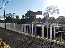
Lindum railway station (27.4420°S 153.1449°E) provides access to regular Queensland Rail City network services to Brisbane and Cleveland.
Demographics
In the 2011 census, the population of Wynnum West was 11,745, 51.4% female and 48.6% male.
The median age of the Wynnum West population was 38 years, one year above the Australian median.
72% of people living in Wynnum West were born in Australia, compared to the national average of 69.8%; the next most common countries of birth were New Zealand 7.4%, England 4.5%, Philippines 1.6%, South Africa 1.1%, Scotland 0.7%.
86.9% of people spoke only English at home; the next most common languages were 0.7% Mandarin, 0.6% Tagalog, 0.6% Filipino, 0.6% Spanish, 0.5% Hindi.
References
- Australian Bureau of Statistics (27 June 2017). "Wynnum West (SSC)". 2016 Census QuickStats. Retrieved 20 October 2018.

- "Wynnum Manly Ward". Brisbane City Council. Brisbane City Council. Archived from the original on 12 March 2017. Retrieved 12 March 2017.
- "Wynnum West – suburb in City of Brisbane (entry 50243)". Queensland Place Names. Queensland Government. Retrieved 11 October 2020.
- "Brisbane GPO to Wynnum West". Google Maps. Retrieved 13 October 2020.
- "Lindum – locality unbounded in City of Brisbane (entry 19450)". Queensland Place Names. Queensland Government. Retrieved 11 October 2020.
- "Lindum – locality unbounded in City of Brisbane (entry 19450)". Queensland Place Names. Queensland Government. Retrieved 11 October 2020.
- "Bomparpin Swamp – wetland in City of Brisbane (entry 3525)". Queensland Place Names. Queensland Government. Retrieved 11 October 2020.
- Jones, Ryan. "Lindum Camp". Mapping Brisbane History. Retrieved 25 August 2020.
- Kerkhove, Ray (2015). Aboriginal Campsites of Greater Brisbane: A Historical Guide. Salisbury: Boolarong Press.
- Queensland places Archived 27 June 2010 at the Wayback Machine
- Queensland Family History Society (2010), Queensland schools past and present (Version 1.01 ed.), Queensland Family History Society, ISBN 978-1-921171-26-0
- "Opening and closing dates of Queensland Schools". Queensland Government. Retrieved 13 October 2020.
- "Union backs bayside schools amalgamation". ABC News. 30 July 2008. Retrieved 13 October 2020.
- "History". Iona College. Retrieved 13 October 2020.
- Australian Bureau of Statistics. "Wynnum West". Archived from the original on 29 October 2013. Retrieved 26 October 2013.
- "Opening and closing dates of Queensland Schools". Queensland Government. Retrieved 18 April 2019.
- "Agency ID 11289, Bayside State College". Queensland State Archives. Retrieved 14 October 2020.
- Australian Bureau of Statistics (31 October 2012). "Wynnum West, Qld (State Suburb)". 2011 Census QuickStats. Retrieved 24 October 2013.
- "Wynnum Plaza". www.wynnumplaza.com. Retrieved 13 October 2020.
- "State and non-state school details". Queensland Government. 9 July 2018. Archived from the original on 21 November 2018. Retrieved 21 November 2018.
- "Wynnum West State School". Retrieved 21 November 2018.
- Wynnum West State School's annual report 2010 official site Archived 21 March 2012 at the Wayback Machine
- "ACARA School Profile 2018". Australian Curriculum, Assessment and Reporting Authority. Retrieved 28 January 2020.
- "Iona College". Retrieved 21 November 2018.
- "Brisbane Bayside State College". Retrieved 21 November 2018.
- "Brisbane Bayside State College - Special Education Program". Retrieved 21 November 2018.
External links
| Wikimedia Commons has media related to Wynnum West, Queensland. |