Virginia, Queensland
Virginia is a suburb in the City of Brisbane, Queensland, Australia.[4] In the 2016 census, Virginia had a population of 2,209 people.[1]
| Virginia Brisbane, Queensland | |||||||||||||||
|---|---|---|---|---|---|---|---|---|---|---|---|---|---|---|---|
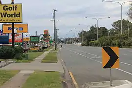 Sandgate Road, 2014 | |||||||||||||||
 Virginia | |||||||||||||||
| Coordinates | 27.3761°S 153.0635°E | ||||||||||||||
| Population | 2,209 (2016 census (suburb))[1] | ||||||||||||||
| • Density | 736/km2 (1,910/sq mi) | ||||||||||||||
| Established | 1880s | ||||||||||||||
| Postcode(s) | 4014 | ||||||||||||||
| Area | 3.0 km2 (1.2 sq mi) | ||||||||||||||
| Time zone | AEST (UTC+10:00) | ||||||||||||||
| Location | 13.9 km (9 mi) NNE of Brisbane GPO | ||||||||||||||
| LGA(s) | City of Brisbane (Deagon Ward;[2] Northgate Ward)[3] | ||||||||||||||
| State electorate(s) | Nudgee | ||||||||||||||
| Federal Division(s) | Lilley | ||||||||||||||
| |||||||||||||||
Geography
Virginia is located about 9.8 kilometres (6.1 mi) from the Brisbane central business district (straight line), the distance by road is approximately 13.9 kilometres (8.6 mi). In addition to the Brisbane central business district, Virginia is centrally located to major employment hubs such as Brisbane Airport - 5.1 kilometres (3.2 mi), Chermside - 3.59 kilometres (2.23 mi) and Port of Brisbane - 9.25 kilometres (5.75 mi). It is primarily a residential suburb with many timber and tin Queenslander style housing.
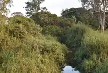
Virginia has a number of parks, including a linear park along Downfall Creek, a recreation reserve and the much larger golf course.[5] There are over 6 parks within the suburb. Majority of parks offer free council facilities such as barbecue (electric and/or wood), playing field, disabled access, water fountains , fitness stations. There are a number of dog parks on the border between Wavell Heights and Virginia, along Downfall creek.
History
Originally occupied mostly by farmlands, Virginia became a district in 1888.[6] With opening of the North Coast railway, the area started to urbanise fairly quickly. A post office was opened in Virginia in 1898. Virginia Primary school opened 1920, which was replaced by Virginia State School in 1920. However, the suburb didn't change its majority industrial character to residential until 1950s.
Virginia State School opened on 2 February 1920.[7] At the 2011 census Virginia had a population of 2,061 people.[8]In the 2016 census, Virginia had a population of 2,209 people.[1]
Education
Virginia State School is a government primary (Prep-6) school for boys and girls at 1678 Sandgate Road (27.3838°S 153.0617°E).[9][10] In 2018, the school had an enrolment of 440 students with 33 teachers (27 full-time equivalent) and 19 non-teaching staff (12 full-time equivalent).[11] It includes a special education program.[9]
Demographics
Virginia is significantly wealthier than Queensland and Australian average. In the 2016 census, Virginia median weekly household income was $2,550, which is higher than Queensland average of $1,222, and higher than Australian average of $1,203.<[12]
In the 2016 census, Virginia recorded a population of 2,209 people; 50.8% female and 49.2% male.[12]
The median age of the Virginia population was 35 years, 3 years below the Australian median. Children aged under 15 years made up 20.3% of the population and people aged 65 years and over made up 10.3% of the population.[12]
75.5% of people living in Virginia were born in Australia, compared to the national average of 66.7%; the next most common countries of birth were New Zealand 4.5%, England 2.9%, India 2.3%, Philippines 1.2%, Nepal 0.6%.[12]
83.2% of people spoke only English at home; the next most popular languages were 1.3% Hindi, 1% Nepali, 1% Punjabi, 0.6% Dutch, 0.6% Mandarin.[12]
Transport
Virginia is extremely well connect to Brisbane CBD, the Brisbane Airport, Redcliffe Peninsula, Shorncliffe and Brisbane in general. Two railway lines run through the suburb. Virginia railway station provides an express, limited stops Queensland Rail City network service to the CBD, Redcliffe Peninsula and Caboolture. Bindha railway station provides access to regular Queensland Rail City network services to Brisbane and Shorncliffe.
In the 2011 census, 17.4% of employed people travelled to work on public transport and 60.3% by car (either as driver or as passenger).[8]
One of Brisbane Transport's bus depots is based in Virginia.
Sport
Despite its name, the Virginia Golf Club is located at Elliott Road, Banyo, an adjacent suburb.[13]
Heritage listings
Heritage-listed sites in Virginia include:
- 1690 Sandgate Road: Virginia State School[14]
References
- Australian Bureau of Statistics (27 June 2017). "Virginia (SSC)". 2016 Census QuickStats. Retrieved 20 October 2018.

- "Deagon Ward". Brisbane City Council. Brisbane City Council. Archived from the original on 9 March 2017. Retrieved 12 March 2017.
- "Northgate Ward". Brisbane City Council. Brisbane City Council. Archived from the original on 12 March 2017. Retrieved 12 March 2017.
- "Virginia – suburb in City of Brisbane (entry 43503)". Queensland Place Names. Queensland Government. Retrieved 12 October 2020.
- Brisbane, City Council. "Virginia parks". www.brisbane.qld.gov.au. Archived from the original on 12 April 2020. Retrieved 28 September 2020.
- "Virginia | Queensland Places". queenslandplaces.com.au. Retrieved 20 January 2021.
- Queensland Family History Society (2010), Queensland schools past and present (Version 1.01 ed.), Queensland Family History Society, ISBN 978-1-921171-26-0
- Australian Bureau of Statistics (31 October 2012). "Virginia (QLD, State Suburb)". 2011 Census QuickStats. Retrieved 16 July 2013.
- "State and non-state school details". Queensland Government. 9 July 2018. Archived from the original on 21 November 2018. Retrieved 21 November 2018.
- "Virginia State School". Archived from the original on 12 April 2019. Retrieved 21 November 2018.
- "ACARA School Profile 2018". Australian Curriculum, Assessment and Reporting Authority. Archived from the original on 27 August 2020. Retrieved 28 January 2020.
- ABS. "2016 Census QuickStats: Virginia (Qld)". Virginia (Qld) QuickStats. ABS. Retrieved 20 January 2021.
- "Virginia Golf Club". Virginia Golf Club. Archived from the original on 14 April 2014. Retrieved 28 April 2014.
- "602860". Queensland Heritage Register. Queensland Heritage Council. Retrieved 29 January 2018.
External links
| Wikimedia Commons has media related to Virginia, Queensland. |
- "Virginia". Queensland Places. Centre for the Government of Queensland, University of Queensland.
- "Virginia". BRISbites. Brisbane City Council. Archived from the original on 24 July 2008.
- "Virginia". Our Brisbane. Brisbane City Council. Archived from the original on 6 March 2008.