Wynnum, Queensland
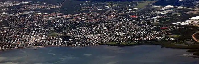
Wynnum is a coastal suburb in the City of Brisbane, Queensland, Australia.[3] In the 2016 census, Wynnum had a population of 12,915.[1] The suburb is a popular destination in Brisbane due to its coastline, jetty and tidal wading pool.
| Wynnum Brisbane, Queensland | |||||||||||||||
|---|---|---|---|---|---|---|---|---|---|---|---|---|---|---|---|
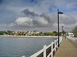 Wynnum foreshore from Wynnum jetty | |||||||||||||||
 Wynnum | |||||||||||||||
| Coordinates | 27.4358°S 153.1691°E | ||||||||||||||
| Population | 12,915 (2016 census)[1] | ||||||||||||||
| • Density | 1,451/km2 (3,758/sq mi) | ||||||||||||||
| Postcode(s) | 4178 | ||||||||||||||
| Area | 8.9 km2 (3.4 sq mi) | ||||||||||||||
| Location | 16 km (10 mi) from Brisbane GPO | ||||||||||||||
| LGA(s) | City of Brisbane (Wynnum Manly Ward)[2] | ||||||||||||||
| State electorate(s) | Lytton | ||||||||||||||
| Federal Division(s) | Bonner | ||||||||||||||
| |||||||||||||||
Geography
Wynnum is on the shores of Moreton Bay in Brisbane, Australia, about 14 kilometres (8.7 mi) east of the CBD.
Toponymy
Wynnum likely derives from a Durubalic word meaning pandanus palm or mud crab.[4]
History
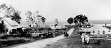
Aboriginal history of Quandamooka (Moreton Bay) stretches back over 25,000 years[5] and Aboriginal connection to the Wynnum area has remained strong throughout European colonisation. Thomas Petrie, a visitor in the 1840s, described Wynnum as a large Aboriginal camp (centred on what is now Elanora Park 27.433°S 153.172°E, referred to as Black's Camp as late as the 1980s[6]) for launching expeditions to hunt turtle, dugong and flying fox on the neighbouring islands.[7] European settlement first appeared at North Wynnum (around the mouth of Wynnum Creek) at the fringe of Black's Camp.[7]
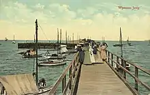
Aboriginal men from Black's Camp helped build the original Wynnum jetty in the 1850s, and in 1886, three local Aboriginal men, 'Johnny Murray, Tommy Nuggin and Sam', saved three European women from drowning in Wynnum Creek.[8] Local Aboriginal people also ran fishing, oyster-catching and turtle hunting enterprises from Wynnum into the early 1900s, with these tours advertised in Brisbane's newspapers.[4] There were some tensions with the European newcomers, including an unprovoked attack by local ruffians on the Aboriginal camp in Wynnum in 1884.[9] Well known Jagera chief 'King Sandy' Kerwalli (aka Gairballie) died at Black's Camp in 1900.[10]
The area remained sparsely settled by Europeans until the arrival of the railway in the late 1880s, but then grew fairly rapidly. On Saturday 22 November 1890, 95 subdivided allotments of Wynnum Station Estate were auctioned by R. J. Cottell. A map advertising the auction show them to be near Bridge Street and close to Wynnum Railway Station.[11][12]
In October 1892 the adherents of the Church of England in Wynnum decided to buy half an acre of land in Charlotte Street (now 77 Charlotte Street, 27.4435°S 153.1718°E) for £50 to erect a church.[13] After some years of fund raising, on Saturday 8 October 1896 the foundation stone was laid in the presence of the Bishop of Brisbane William Webber and the Premier of Queensland James Robert Dickson.[14] St Peter's Anglican Church was officially opened and dedicated on Thursday 9 March 1899.[15]
The former Wynnum Shire Council was created in 1902, and twelve years later Wynnum became a municipality with its own town council and the right to elect a mayor. Black's Camp was disbanded in 1908, and the area was redeveloped into Elanora Park in the 1930s.[16] The Wynnum Town Council was absorbed into the enlarged City of Brisbane in 1925.[17]
Wynnum State School opened on 24 February 1896. In 1910 it was renamed Wynnum Central State School.[18] It closed on 31 December 2010 as it was amalgamated with Lindum State School and Wynnum North State School in Prospect Street to create a new Wynnum State School.[19]
Wynnum North State School was established in 1911. The school originally opened in 1882 as Lytton State School but the buildings were relocated from Lytton to Wynnum North and the school renamed Wynnum North State School in 1911.[18] It closed on 31 December 2010 as it was amalgamated with Lindum State School and Wynnum Central State School to create a new Wynnum State School.[19]
Guardian Angels Catholic Primary School opened on 4 October 1914.[18]
St John's Anglican Church was dedicated circa 1929. It was at 54 Randall Street (approx 27.4551°S 153.1584°E).[20] It closed circa 1995.[21]
The Wynnum Seventh-day Adventist Church was established in late 1937 with the first minister being Pastor Septimus Wilfred Carr. Initially they met in private homes and then relocated the Wynnum RSL Hall and then at the Wynnum St Peters Church of England Hall. In 1947 a block of land was purchased at the corner of Sunflower and Carnation Street, Wynnum and in 1948 the Mitchelton Methodist Hall was purchased and moved to the site as the congregations' first church.[22]
Wynnum State High School opened on 2 March 1942.[18]
In 1956 Anglicans in Wynnum constructed a Sunday school at Primrose Parade (Sibley Road end, approx 27.4409°S 153.1552°E). In 1964 they constructed a church hall, which was dedicated on 3 May 1964 by Coadjutor Bishop John Hudson as St Margaret's Anglican Church Hall. In 1984 the new St Peter's Anglican Church opened at 77 Charlotte Street and this led to the closure of St Margaret's Church Hall on 11 August 1985, after which St Margaret's was relocated to Murrarie to become St Clare's Anglican Church and the Primrose Parade site was sold for residential development.[21][23]
Mount Carmel College opened in 1957. It closed on 31 December 1992.[18]
St Oswald's Anglican Church in Wynnum North was dedicated circa 1957.[21] It was in Prospect Street.[24] In 1967 this church established the first Meals on Wheels service in Wynnum.[25][26] The church closed circa 1981.[21][24]
Wynnum North State High School opened on 28 January 1964.[18]
The suburb has traditionally boasted a country town atmosphere, but new residential development is resulting in significant population growth and changing demographics. The area is now marked by a mix of character housing and modern housing.
In 1987 Pandanus Beach was constructed by and bringing sand from North Stradbroke Island and building rock groynes to try to prevent the sand from being eroded by the action of the waves in the bay. On 26 September 1987 Pandanus Beach was officially opened by Tom Burns, the Member of the Queensland Legislative Assembly for Lytton and resident of Wynnym.[27]
Demographics
In the 2011 census, the population of Wynnum was 12,229, 51.1% female and 48.9% male.[28]
The median age of the Wynnum population was 40 years, 3 years above the Australian median.
73.7% of people living in Wynnum were born in Australia, compared to the national average of 69.8%; the next most common countries of birth were New Zealand 6.2%, England 5.3%, Philippines 0.9%, Scotland 0.8%, South Africa 0.5%.
88.9% of people spoke only English at home; the next most common languages were 0.5% Tagalog, 0.4% German, 0.4% Vietnamese, 0.3% Filipino, 0.3% Spanish.
Heritage listings
.jpg.webp)
Wynnum has a number of heritage-listed sites, including:
- 199 Bay Terrace: Mount Carmel Convent[29]
- 75 Berrima Street: Waterloo Bay Hotel[30]
- The Esplanade: Wynnum Wading Pool[31]
- 39 Mountjoy Terrace: former Wynnum Fire Station[32]
- Peel Street (27.4543°S 153.1763°E): Wynnum State High School Block A[33]
- 33 Tingal Road: former Wynnum Ambulance Station[34]
- 272 Wynnum North Road: Nazareth House[35]
These examples are from the Queensland Heritage Register. Additional sites are listed on the Brisbane Heritage Register and the Australian Heritage Database.
Transport
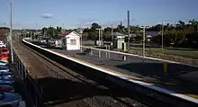
Wynnum is served by three stations on the Cleveland railway line. Wynnum North railway station, Wynnum railway station and Wynnum Central railway station provide access to regular Queensland Rail City network services to Brisbane and Cleveland.
Education
Wynnum State School is a government primary (Early Childhood-6) school for boys and girls at 81 Boxgrove Avenue (27.4416°S 153.1602°E).[36][37] In 2018, the school had an enrolment of 754 students with 57 teachers (51 full-time equivalent) and 36 non-teaching staff (22 full-time equivalent).[38] It includes a special education program.[36]
Guardian Angels' Primary School is a Catholic primary (Prep-6) school for boys and girls at 188 Bay Terrace (27.4458°S 153.1758°E).[36][39] In 2018, the school had an enrolment of 546 students with 40 teachers (34 full-time equivalent) and 25 non-teaching staff (15 full-time equivalent).[38]
Wynnum State High School is a government secondary (7-12) school for boys and girls at Peel Street (27.4549°S 153.1766°E).[36][40] In 2018, the school had an enrolment of 875 students with 78 teachers (75 full-time equivalent) and 30 non-teaching staff (24 full-time equivalent).[38] It includes a special education program.[36]
Moreton Bay Environmental Education Centre is a special purpose school facility at 162 Stradbroke Avenue (27.4411°S 153.1635°E).[36][41]
Amenities
The Brisbane City Council operates a public library located at 145 Florence Street.[42] The library opened in 1946 with a major refurbishment in 2016 and offers publicly accessible Wi-Fi.[43]
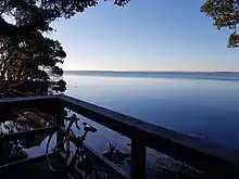
The Bayside Parklands provide public access to 16 kilometres (9.9 mi) of shoreline including mangroves, mudflats and wetlands. Many migratory shorebirds can be seen from the parklands as Moreton Bay is a Ramsar site. Next to the Wynnum Wading Pool which has a playground and water park and the Wynnum Jetty, there is a man-made beach called Pandanus Beach.[44]
Sports and recreational activities
It also has an extensive range of long established sporting clubs, such as Wynnum Seagulls Rugby League Club, Wynnum Golf Club, Wynnum District SC (Wolves FC Soccer Club - since 1921), Wynnum Manly District Cricket Club, Wynnum Bugs Rugby Union Club, Bayside United Soccer Club and Wynnum Vikings Australian Rules Football Club. Wynnum Esplanade hosts Wynnum parkrun every Saturday - a free weekly 5 kilometres (3.1 mi) walk/run which attracts many participants. Recreational clubs include the Wynnum Manly Leagues Club and the RSL. The Wynnum foreshore is a popular swimming and picnic spot for Brisbane families especially at weekends.
Community groups
The Bay Belles branch of the Queensland Country Women's Association meets at the Wynnum RSL at 174 Tingal Road (27.4438°S 153.1694°E).[45]
Notable residents
The following were either born or have lived at some time in Wynnum:
- Quentin Bryce - former Governor General of Australia
- Kay Danes - human rights activist, memoirist
- Keith Rayner - former Anglican Archbishop of Melbourne
- Samantha Riley - olympic swimming medallist
- Kyle Sandilands - radio host
- Stacey Thomson - television host
Population growth
| Census date | Population |
|---|---|
| Wynnum | |
| 1891 | 0683 |
| 1911 | 2320 |
| 1921 | 8357 |
| 1933 | 12,905 |
| 1954 | 18,479 |
| Wynnum and Lota | |
| 1961 | 22,007 |
| 1971 | 24,064[46] |
References
- Australian Bureau of Statistics (27 June 2017). "Wynnum, Qld (State Suburb)". 2016 Census QuickStats. Retrieved 24 October 2013.

- "Wynnum Manly Ward". Brisbane City Council. Brisbane City Council. Archived from the original on 12 March 2017. Retrieved 12 March 2017.
- "Wynnum – suburb in City of Brisbane (entry 45510)". Queensland Place Names. Queensland Government. Retrieved 28 December 2017.
- Kerkhove, Ray. "Wynnum Notes and Quotes". Archived from the original on 24 August 2020. Retrieved 22 August 2020. Cite journal requires
|journal=(help) - Hall, J (1977). A Working Model of Moreton Island Prehistory: MRAP Stage 1. CiteSeerX 10.1.1.909.4614.
- "Wednesday, 13 May 1981" (PDF). Queensland Parliamentary Debates Hansard: 1268. Archived (PDF) from the original on 15 September 2020. Retrieved 24 August 2020.
- Kerkhove, Ray (2018). "Aboriginal camps as urban foundations? Evidence from southern Queensland" (PDF). Aboriginal History. 42: 141–172. doi:10.22459/AH.42.2018.07. Archived (PDF) from the original on 2 August 2019. Retrieved 23 August 2020.
- "20 February, page 24". The Capricornian (Rockhampton). 1886. Archived from the original on 24 August 2020. Retrieved 23 August 2020.
- "Wednesday 2 January 1884, page 4". The Brisbane Courier. 1884. Archived from the original on 24 August 2020. Retrieved 23 August 2020.
- Jones, Ryan. "Wynnum Camp". Mapping Brisbane History. Archived from the original on 24 August 2020. Retrieved 23 August 2020.
-
 This Wikipedia article incorporates CC-BY-4.0 licensed text from: "Wynnum State Estate". State Library of Queensland. State Library of Queensland. Retrieved 5 June 2020.
- "Advertising". The Telegraph. Queensland, Australia. 18 November 1890. p. 8 (Second Edition). Archived from the original on 24 August 2020. Retrieved 5 June 2020 – via Trove.
- "TO-DAY.—OCTOBER 14". The Brisbane Courier. XLIX (10, 843). Queensland, Australia. 14 October 1892. p. 4. Archived from the original on 15 September 2020. Retrieved 14 September 2020 – via National Library of Australia.
- "New Anglican Church". The Telegraph (8, 078). Queensland, Australia. 10 October 1898. p. 4. Retrieved 14 September 2020 – via National Library of Australia.
- "Anglican Church, Wynnum". The Telegraph (8, 207). Queensland, Australia. 9 March 1899. p. 5. Archived from the original on 15 September 2020. Retrieved 15 September 2020 – via National Library of Australia.
- Jones, Ryan. "Wynnum Camp". Mappping Brisbane History. Archived from the original on 24 August 2020. Retrieved 23 August 2020.
- Mangroves to Moorings Revisited, Myrtle Beitz, 2005
- Queensland Family History Society (2010), Queensland schools past and present (Version 1.01 ed.), Queensland Family History Society, ISBN 978-1-921171-26-0
- "Opening and closing dates of Queensland Schools". Queensland Government. Retrieved 13 October 2020.
- Universal Business Directories (Aust.) Pty. Ltd (1990). UBD street directory. Brisbane. Universal Business Directories (Australia). Archived from the original on 24 August 2020. Retrieved 15 September 2020.
- "Closed Churches". Anglican Church of Southern Queensland. Archived from the original on 3 April 2019. Retrieved 24 February 2019.CS1 maint: unfit URL (link)
- "Short History of Wynnum Seventh-day Adventist Church". South Queensland Adventist Heritage. Archived from the original on 17 February 2017. Retrieved 13 March 2017.
- Beitz, Myrtle; Greenhill, Jill (May 2010). "St Margaret's Anglican Church Hall" (PDF). Newsletter. Wynnum Manly Historical Society. pp. 6–7. Archived (PDF) from the original on 14 September 2020. Retrieved 14 September 2020.
- Gregory's Street Directory of Brisbane and Suburbs and Metropolitan Road Guide (11 ed.). 1975. p. 108.
- "Pioneering Wynnum Volunteer Still Delivering Meals-on-Wheels Even After 50 Years". Wynnum Today. Archived from the original on 14 September 2020. Retrieved 14 September 2020.
- "First week's operations successful" (PDF). Newsletter. Wynnum Manly Historical Society. February 2016. p. 6. Archived (PDF) from the original on 15 September 2020. Retrieved 15 September 2020.
- "The Development of Beaches in Wynnum Manly" (PDF). Newsletter. Wynnum Manly Historical Society (74): 6. July 2007. Archived (PDF) from the original on 28 September 2020. Retrieved 28 September 2020.
- "2011 Census Community Profiles: Wynnum". www.censusdata.abs.gov.au. Archived from the original on 19 April 2018. Retrieved 31 January 2017.
- "Mount Carmel Convent (entry 601730)". Queensland Heritage Register. Queensland Heritage Council. Retrieved 6 July 2013.
- "Waterloo Bay Hotel (entry 601729)". Queensland Heritage Register. Queensland Heritage Council. Retrieved 6 July 2013.
- "Wynnum Wading Pool Reserve (entry 602040)". Queensland Heritage Register. Queensland Heritage Council. Retrieved 6 July 2013.
- "Wynnum Fire Station (former) (entry 602143)". Queensland Heritage Register. Queensland Heritage Council. Retrieved 6 July 2013.
- "650059". Queensland Heritage Register. Queensland Heritage Council. Retrieved 8 November 2020.
- "Wynnum Ambulance Station (former) (entry 601778)". Queensland Heritage Register. Queensland Heritage Council. Retrieved 6 July 2013.
- "Nazareth House (entry 601391)". Queensland Heritage Register. Queensland Heritage Council. Retrieved 6 July 2013.
- "State and non-state school details". Queensland Government. 9 July 2018. Archived from the original on 21 November 2018. Retrieved 21 November 2018.
- "Wynnum State School". Archived from the original on 9 May 2012. Retrieved 21 November 2018.
- "ACARA School Profile 2018". Australian Curriculum, Assessment and Reporting Authority. Archived from the original on 27 August 2020. Retrieved 28 January 2020.
- "Guardian Angels' Primary School". Archived from the original on 27 February 2015. Retrieved 21 November 2018.
- "Wynnum State High School". Archived from the original on 12 November 2011. Retrieved 21 November 2018.
- "Moreton Bay Environmental Education Centre". Archived from the original on 5 January 2019. Retrieved 21 November 2018.
- "Wynnum Library". Public Libraries Connect. 15 December 2017. Archived from the original on 29 January 2018. Retrieved 29 January 2018.
- "Queensland Public Libraries Statistical Bulletin" (PDF). Public Libraries Connect. November 2017. Archived (PDF) from the original on 30 January 2018. Retrieved 29 January 2018.
- "Bayside Parklands". Brisbane City Council. Archived from the original on 28 September 2020. Retrieved 28 September 2020.
- "Branch Locations". Queensland Country Women's Association. Archived from the original on 26 December 2018. Retrieved 26 December 2018.
- "Wynnum - Queensland Places". queenslandplaces.com.au. Archived from the original on 7 October 2017. Retrieved 19 April 2018.
Further reading
- St. Peter's Wynnum: diamond jubilee, 1899-1974, The Parish, 1974
- Hughes, Peter D; Hogan, Thelma (1999), Fishers of men: a history of the Anglican Church of Saint Peter's Wynnum, 1899-1999, [Cooroy, Qld.] printed by Queensland Media Print
External links
| Wikimedia Commons has media related to Wynnum, Queensland. |