Mansfield, Queensland
Mansfield is a suburb in the City of Brisbane, Queensland, Australia.[3] In the 2016 census, Mansfield had a population of 8,695 people.[1]
| Mansfield Brisbane, Queensland | |||||||||||||||
|---|---|---|---|---|---|---|---|---|---|---|---|---|---|---|---|
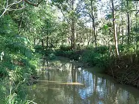 Bulimba Creek at Wecker Road, 2014 | |||||||||||||||
 Mansfield | |||||||||||||||
| Coordinates | 27.5336°S 153.1025°E | ||||||||||||||
| Population | 8,695 (2016 census)[1] | ||||||||||||||
| • Density | 1,774/km2 (4,600/sq mi) | ||||||||||||||
| Established | 1967 (gazetted) | ||||||||||||||
| Postcode(s) | 4122 | ||||||||||||||
| Area | 4.9 km2 (1.9 sq mi) | ||||||||||||||
| Time zone | AEST (UTC+10:00) | ||||||||||||||
| Location | 13.5 km (8 mi) SSE of Brisbane GPO | ||||||||||||||
| LGA(s) | City of Brisbane (Chandler Ward)[2] | ||||||||||||||
| State electorate(s) | Mansfield | ||||||||||||||
| Federal Division(s) | Bonner | ||||||||||||||
| |||||||||||||||
Geography
Mansfield is situated approximately 13.5 kilometres (8.4 mi) by road south-south-east of the Brisbane CBD.[4]
Part of the eastern boundary of the suburb is marked by the Gateway Motorway.[5]
There is a medium-sized industrial estate situated in the northern part of the suburb, in which an Australia Post mail delivery centre is located.
History
The suburb has an agricultural past, consisting mainly of dairy cattle and sheep grazing. Original fencelines can still be found in remaining pockets of bushland. There was also light development of industries related to agriculture, such as wool processing and scouring. Also the quarry once located on Ham and Wecker Roads, excavated large amounts of sandstone used throughout some of the historic landmarks of Brisbane, such as the Brisbane City Hall.
The suburb was named by the Queensland Place Names Board on 1 August 1967, after the Queensland Governor of the time Sir Alan Mansfield. [3]
Large portions of Mansfield were originally constructed as government housing estates, however these have progressively been replaced by more modern private residences. Due to the increasing unavailability and expense of land closer to the CBD, the area is currently experiencing a period of socio-economic growth and renewal.
Brisbane Adventist College Primary Campus opened on 25 January 1966.[6]
Mansfield State School opened on 27 January 1970.[6]
Brisbane Adventist College Secondary Campus opened on 1973.[6]
Mansfield State High School opened on 29 January 1974.[6]
Christian Outreach College opened in Mansfield on 16 May 1978.[6] However it is now within the suburb of Carindale just over the northern border with Mansfield.[5]
In 1999 the Brisbane Adventist Primary and Secondary Campuses amalgamated to created Brisbane Adventist College.[6]
The Mansfield Tavern has served as a venue for many local and touring musical acts. The venue has featured acts as The Offspring, Wickety Wak, Fear Factory, Hunters & Collectors, Madness, Hoodoo Gurus, The Angels and British rock band The Cult.[7]
In the 2016 census, Mansfield had a population of 8,695 people.[1]
Education
Mansfield State School is a government primary (Prep-6) school for boys and girls at 174 Ham Road (27.5423°S 153.1053°E).[8][9] In 2017, the school had an enrolment of 1032 students with 73 teachers (60 full-time equivalent) and 32 non-teaching staff (21 full-time equivalent).[10] It includes a special education program.[8]
Mansfield State High School is a government secondary (7-12) school for boys and girls at Corner Broadwater & Ham Road (27.5454°S 153.1058°E).[8][11] In 2017, the school had an enrolment of 2448 students with 172 teachers (161 full-time equivalent) and 59 non-teaching staff (43 full-time equivalent).[10] It includes a special education program.[8]
Brisbane Adventist College is a private primary and secondary (Prep-12) school for boys and girls at 303A Broadwater Road (27.5445°S 153.0976°E).[8][12] In 2017, the school had an enrolment of 522 students with 46 teachers (40 full-time equivalent) and 19 non-teaching staff (14 full-time equivalent).[10]
Transport
Mansfield has regular bus services to the CBD and to the Westfield Garden City shopping centre at Upper Mount Gravatt.
Parks
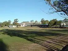
Arguably the greatest asset of the Mansfield area is its remaining pockets of bushland and parklands. The largest public park in Mansfield, Broadwater Park, is a reasonably large open space with barbecue areas and children's play equipment. Adjoining this parkland is a large bushland reserve which follows the course of Bulimba Creek (a tributary of the Brisbane River).
Demographics
Mansfield is located in the region of the city which is now colloquially known as the "Bible Belt" due to the large number of people who have settled there to be close to Christian schools and churches.[13]
The suburb recorded a population of approximately 8,700 at the 2016 census.[1] The suburb has a moderate Greek presence with under 2.3% of the population speaking Greek as a first language.[1]
In the 2011 census the population of Mansfield was 8,473, 51.8% female and 48.2% male. The median age of the Mansfield population was 38 years of age, 1 year above the Australian median. 69.8% of people living in Mansfield were born in Australia, compared to the national average of 69.8%; the next most common countries of birth were New Zealand 3.8%, England 2.9%, South Africa 1.5%, India 1.4%, China 1.1%. 76.1% of people spoke only English at home; the next most common languages were 2.8% Greek, 2.6% Cantonese, 1.3% Mandarin, 1.2% Arabic, 1% Hindi.
References
- Australian Bureau of Statistics (27 June 2017). "Mansfield (SSC)". 2016 Census QuickStats. Retrieved 20 October 2018.

- "Chandler Ward". Brisbane City Council. Brisbane City Council. Retrieved 12 March 2017.
- "Mansfield – suburb in City of Brisbane (entry 47605)". Queensland Place Names. Queensland Government. Retrieved 26 January 2020.
- Google (2 April 2020). "Brisbane GPO to Mansfield" (Map). Google Maps. Google. Retrieved 2 April 2020.
- "Queensland Globe". State of Queensland. Retrieved 1 April 2020.
- Queensland Family History Society (2010), Queensland schools past and present (Version 1.01 ed.), Queensland Family History Society, ISBN 978-1-921171-26-0
- "Mansfield Tavern".
- "State and non-state school details". Queensland Government. 9 July 2018. Archived from the original on 21 November 2018. Retrieved 21 November 2018.
- "Mansfield State School". Retrieved 21 November 2018.
- "ACARA School Profile 2017". Archived from the original on 22 November 2018. Retrieved 22 November 2018.
- "Mansfield State High School". Retrieved 21 November 2018.
- "Brisbane Adventist College". Retrieved 21 November 2018.
- "Couriermail.com.au".
External links
| Wikimedia Commons has media related to Mansfield, Queensland. |
- "Mansfield". Queensland Places. Centre for the Government of Queensland, University of Queensland.