Geebung, Queensland
Geebung is a suburb in the City of Brisbane, Queensland, Australia.[4] In the 2016 census, Geebung had a population of 4626 people.[5]
| Geebung Brisbane, Queensland | |||||||||||||||
|---|---|---|---|---|---|---|---|---|---|---|---|---|---|---|---|
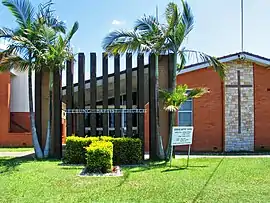 Geebung Baptist Church (now the Tonga Houʻeiki Church), 2007 | |||||||||||||||
| Population | 4,626 (2016 census)[1] | ||||||||||||||
| • Density | 1,160/km2 (3,000/sq mi) | ||||||||||||||
| Postcode(s) | 4034 | ||||||||||||||
| Area | 4 km2 (1.5 sq mi) | ||||||||||||||
| Location | 12 km (7 mi) from Brisbane CBD | ||||||||||||||
| LGA(s) | City of Brisbane (Deagon Ward;[2] Marchant Ward)[3] | ||||||||||||||
| State electorate(s) | Nudgee Stafford Aspley | ||||||||||||||
| Federal Division(s) | Lilley | ||||||||||||||
| |||||||||||||||
Geography
The suburb is centred on its railway station on the Caboolture railway line.
History
The suburb takes its name from its railway station, which in turn was named after the fruit of the plant Persoonia media, known as "jibung" in the Dharuk language.[4]
The Geebung Baptist church was initiated with a stump capping ceremony on Saturday 7 February 1925; prior to this services had been held in the war memorial hall.[6] On Saturday 14 February 1926, the church was opened in a ceremony attended by 150 people. It was made of weatherboard and could seat about 100 people. The church (including fencing, the organ, the seating etc.) cost £543/12/0 having spent £80 for the land.[7] A new church was built about the 1960s. In May 2012 the Geebung Baptist congregation merged with the Sandgate Baptist congregation, selling their existing churches and establishing a new church, Connect Baptist Church at Deagon.[8][9] In August 2013, the Geebung Baptist church was purchased by the Tonga Houʻeiki Church for $1.5 million, although the decision to purchase was controversial within the Tongan congregation.[10] The church is at 27 Innes Street (27.3703°S 153.0464°E).[11]
During World War II the southern piece of Geebung was host to the Chermside Army Camp, which occupied land that includes part of the present day Marchant Park.[12] Two years after the war, ISAS (Industrial Sales and Service) assembled war surplus Nissen huts for their business on Robinson Road in north Geebung. In 1949, the Brisbane City Council zoned that territory for general industry.[13]
Geebung State School opened on 27 January 1953.[14]
On Saturday 28 September 1963 Archbishop Philip Strong laid the foundation stone for St Mary the Virgin Anglican Church at 44-46 Innes Street (27.3710°S 153.0467°E).[15] The church was officially opened and dedicated on 16 November 1963 by Archbishop Strong and consecrated on 24 March 1974 by Archbishop Felix Arnott. Its closure on 23 July 2000 was approved by Assistant Bishop Appleby.[16] As at September 2020, it is used as a residence.[17]
St Kevin's Catholic Primary School opened in January 1964.[14]
The R H Kirkley Education Centre opened on 21 May 1979 was opened as a school for students requiring significant educational support due to intellectual and other disabilities. It was later renamed R H. Kirkley Special School and then Geebung Special School on 1 January 1986.[14]
The suburb was the location for a significant fossil discovery in 2013. The fossils were the remains of a rare 50-million-year-old crocodile like species and several other animals.[18]
Demographics
In the 2011 census the population of Geebung was 4,620: 51.1% female and 48.9% male.[19]
The median age of the Geebung population was 37 years, the same as the national median.
77.5% of people living in Geebung were born in Australia, compared to the national average of 69.8%; the next most common countries of birth were New Zealand 4.5%, England 2.6%, India 1.4%, Philippines 1.1%, China 0.6%. 86.9% of people spoke only English at home; the next most popular languages were 0.9% Italian, 0.9% Mandarin, 0.8% Punjabi, 0.8% Hindi, 0.5% Samoan.
Transport
Geebung railway station and Sunshine railway station provides access to regular Queensland Rail City network services to Brisbane and Ipswich, as well as Caboolture and the Sunshine Coast.
On the day of the 2011 census, 15.6% of employed people travelled to work on public transport and 62.1% by car (either as driver or as passenger).[19]
Industry
Geebung is host to a wide range of commercial business-to-business companies. Some of the most notable occupants include Slade Health, A. H. Beard, Austate Removals and Action Aluminuim.
Education
Geebung State School is a government primary (Prep-6) school for boys and girls at 250 Newman Road (27.3751°S 153.0466°E).[20][21] In 2017, the school had an enrolment of 318 students with 24 teachers (19 full-time equivalent) and 18 non-teaching staff (11 full-time equivalent).[22] It includes a special education program.[20][23]
Geebung Special School is a special primary (Early Childhood-6) school for boys and girls at Beau Vista Street (27.3785°S 153.0509°E).[20][24] In 2017, the school had an enrolment of 100 students with 34 teachers (28 full-time equivalent) and 45 non-teaching staff (26 full-time equivalent).[22]
St Kevin's School is a Catholic primary (Prep-6) school for boys and girls at 249 Newman Road (27.3738°S 153.0471°E).[20][25] In 2017, the school had an enrolment of 271 students with 23 teachers (17 full-time equivalent) and 16 non-teaching staff (9 full-time equivalent).[22]
References
- Australian Bureau of Statistics (27 June 2017). "Geebung (State Suburb)". 2016 Census QuickStats. Retrieved 18 April 2018.

- "Deagon Ward". Brisbane City Council. Brisbane City Council. Archived from the original on 9 March 2017. Retrieved 12 March 2017.
- "Marchant Ward". Brisbane City Council. Brisbane City Council. Archived from the original on 12 March 2017. Retrieved 12 March 2017.
- "Geebung – suburb in City of Brisbane (entry 48302)". Queensland Place Names. Queensland Government. Retrieved 10 June 2019.
- Australian Bureau of Statistics (27 June 2017). "Geebung (SSC)". 2016 Census QuickStats. Retrieved 20 October 2018.
- "GEEBUNG PROGRESS". The Daily Mail (88). Queensland, Australia. 8 February 1925. p. 18. Archived from the original on 15 September 2020. Retrieved 9 August 2019 – via National Library of Australia.
- "BAPTIST CHURCH". The Daily Mail (7191). Queensland, Australia. 16 March 1925. p. 7. Archived from the original on 15 September 2020. Retrieved 9 August 2019 – via National Library of Australia.
- "Better together! Recent church mergers in Queensland Baptists". The qb magazine: 32–33. August–September 2017. Archived from the original on 9 August 2019. Retrieved 15 September 2020.
- "Connect Baptist Church - Deagon". Connect Baptist Church. Archived from the original on 9 August 2019. Retrieved 9 August 2019.
- Latu, Kalino (23 August 2013). "AUD$1.5 million real estate purchase splits Brisbane Tonga Houʻeiki Church". Kaniva News. Archived from the original on 9 August 2019. Retrieved 9 August 2019.
- "Church of Tonga (Siasi 'O Tonga)". Churches Australia. Archived from the original on 15 September 2020. Retrieved 15 September 2020.
- "Chermside Army Camp". Queensland WWII Historic Places. 30 June 2014. Archived from the original on 10 October 2019. Retrieved 10 October 2019.
- "Geebung Building with Splayed Sides". Chermside & Districts Historical Society. Archived from the original on 10 October 2019. Retrieved 10 October 2019.
- Queensland Family History Society (2010), Queensland schools past and present (Version 1.01 ed.), Queensland Family History Society, ISBN 978-1-921171-26-0
- "St Mary the Virgin Anglican Church - Former". Churches Australia. Archived from the original on 15 September 2020. Retrieved 15 September 2020.
- "Closed Churches". Anglican Church of Southern Queensland. Archived from the original on 3 April 2019. Retrieved 24 February 2019.CS1 maint: unfit URL (link)
- "Leased - 46 Innes Street, Geebung, QLD - House Leased". Ray White Group. Archived from the original on 15 September 2020. Retrieved 15 September 2020.
- Moore, Tony (16 July 2013). "'Phenomenal' fossil find in Brisbane's north". Brisbane Times. Fairfax Media. Archived from the original on 16 March 2014. Retrieved 16 July 2013.
- Australian Bureau of Statistics (31 October 2012). "Geebung (State Suburb)". 2011 Census QuickStats. Retrieved 16 July 2013.
- "State and non-state school details". Queensland Government. 9 July 2018. Archived from the original on 21 November 2018. Retrieved 21 November 2018.
- "Geebung State School". Archived from the original on 15 March 2020. Retrieved 21 November 2018.
- "ACARA School Profile 2017". Archived from the original on 22 November 2018. Retrieved 22 November 2018.
- "Geebung SS - Special Education Program". Archived from the original on 15 March 2020. Retrieved 21 November 2018.
- "Geebung Special School". Archived from the original on 7 April 2012. Retrieved 21 November 2018.
- "St Kevin's School". Archived from the original on 31 July 2012. Retrieved 21 November 2018.
Further reading
- Geebong Story - Being the history of Geebung and including the Zillman's Waterholes, Sandgate, Downfall Creek, Deadman's Gully, Cabbage Tree Creek, Happy Valley and Virginia from early settlement to the end of World War I. by Kath Ballard, Geebung Qld 1995.
- Geebung Story: The Next Fifty Years - Being the history of Geebung (with other name for three years) and surrounding north side suburbs including Nundah, Albion, Zillmere, Virginia, Chermside and Sandgate. Embracing Brisbane to the Pine River and beyond and to the bayside areas with an enormous amount of WW2 years of both Australian and American, including a previously unrecorded Chermside Camp map with story and photographs. Every page with names, names, names. by Kath Ballard, Geebung Qld 1998.
External links
| Wikimedia Commons has media related to Geebung, Queensland. |
- University of Queensland: Queensland Places: Geebung
- "Geebung". BRISbites. Brisbane City Council. Archived from the original on 20 July 2008.
- "Geebung". Our Brisbane. Brisbane City Council. Archived from the original on 16 January 2008.
- Picture of Geebung tree with fruit.