Upper Brookfield, Queensland
Upper Brookfield is an outer western suburb in the City of Brisbane, Queensland, Australia.[3] In the 2016 census, Upper Brookfield had a population of 785 people.[1]
| Upper Brookfield Brisbane, Queensland | |||||||||||||||
|---|---|---|---|---|---|---|---|---|---|---|---|---|---|---|---|
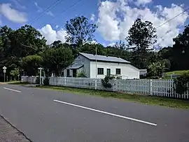 The Upper Brookfield Community Hall | |||||||||||||||
 Upper Brookfield | |||||||||||||||
| Coordinates | 27.4697°S 152.8530°E | ||||||||||||||
| Population | 785 (2016 census (suburb))[1] | ||||||||||||||
| • Density | 21.51/km2 (55.70/sq mi) | ||||||||||||||
| Postcode(s) | 4069 | ||||||||||||||
| Area | 36.5 km2 (14.1 sq mi) | ||||||||||||||
| Time zone | AEST (UTC+10:00) | ||||||||||||||
| LGA(s) | City of Brisbane (Pullenvale Ward)[2] | ||||||||||||||
| State electorate(s) | Moggill | ||||||||||||||
| Federal Division(s) | Ryan | ||||||||||||||
| |||||||||||||||
Geography
Upper Brookfield is a mountainous rural suburb consisting of acreage properties. It is 16 kilometres (9.9 mi) west of the Brisbane CBD.
Marshalls Flat is a plain (27.4702°S 152.8469°E) alongside Moggill Creek in the centre of the suburb. It named after husband and wife Arthur John (Jack) Marshall (1913-2003) and Kathleen Bell Marshall (1915-2005), owners and farmer of the flats from 1944 to 1976.[4]
History
Upper Brookfield is named after its neighbouring suburb Brookfield. The name came into use about 1910 but it was not officially named and bounded until 11 August 1975.[3]
Upper Brookfield State School (also known as Brookfield Upper State School) opened on 1916 but closed in 1921 due to low student numbers. It reopened in 1923.[5] A Methodist Church opened in Brookfield on Saturday 29 November 1952.[6]
At the 2011 census Upper Brookfield had a population of 655 people.[7]
In the 2016 census, Upper Brookfield had a population of 785 people.[1]
Education
Upper Brookfield State School is a government primary (Prep-6) school for boys and girls at 496 Upper Brookfield Road (27.4780°S 152.8691°E).[8][9] In 2018, the school had an enrolment of 54 students with 7 teachers (4 full-time equivalent) and 6 non-teaching staff (3 full-time equivalent).[10]
There is no secondary school in Upper Brookfield. The nearest secondary school in Kenmore State High School in Kenmore to the south-east.[11]
Amenities
Upper Brookfield Community Hall is at 506 Upper Brookfield Road (27.4775°S 152.8682°E).
Demographics
In the 2016 Census, there were 785 people in Upper Brookfield (State Suburbs). Of these 49.2% were male and 50.8% were female. Aboriginal and/or Torres Strait Islander people made up 0.5% of the population.
The median age of people was 42 years. Children aged 0 - 14 years made up 21.9% of the population and people aged 65 years and over made up 14.4% of the population.
The most common responses for religion were No Religion, so described 42.1%, Catholic 14.9%, Not stated 13.6%, Anglican 10.3% and Uniting Church 6.1%. In Upper Brookfield (State Suburbs), No Religion, so described was the largest religious group reported overall (49.1%) (this figure excludes not stated responses).
The most common countries of birth for male parents were Australia 59.1%, England 9.8%, South Africa 3.3%, New Zealand 2.8% and Netherlands 2.5%.
The most common countries of birth for female parents were Australia 60.2%, England 7.9%, South Africa 3.3%, Netherlands 2.8% and New Zealand 1.9%.
87.1% of people only spoke English at home. The only other responses for language spoken at home were German 1.6%, Spanish 0.8%, Dutch 0.5% and Italian 0.4%.
There were 393 people who reported being in the labour force in the week before Census night. Of these 55.0% were employed full time, 34.6% were employed part-time and 5.6% were unemployed.Of employed people, 17.1% worked 1 to 15 hours, 10.6% worked 16 to 24 hours and 43.1% worked 40 hours or more.
Of people aged 15 years and over, 62.4% were married and 7.7% were either divorced or separate
In the 2011 census, the population of Upper Brookfield was 655, 49.6% female and 50.4% male.
The median age of the Upper Brookfield population was 42 years, 5 years above the Australian median.
78.7% of people living in Upper Brookfield were born in Australia, compared to the national average of 69.8%; the next most common countries of birth were England 6%, South Africa 2%, New Zealand 1.8%, Netherlands 1.4%, United States of America 1.1%.
96% of people speak only English at home; the next most common languages were 0.6% Dutch, 0.6% German, 0.5% French, 0.5% Italian, 0.5% Spanish.
References
- Australian Bureau of Statistics (27 June 2017). "Upper Brookfield (SSC)". 2016 Census QuickStats. Retrieved 20 October 2018.

- "Pullenvale Ward". Brisbane City Council. Brisbane City Council. Archived from the original on 12 March 2017. Retrieved 12 March 2017.
- "Upper Brookfield – suburb in City of Brisbane (entry 49694)". Queensland Place Names. Queensland Government. Retrieved 12 October 2020.
- "Marshalls Flat – plain in City of Brisbane (entry 49834)". Queensland Place Names. Queensland Government. Retrieved 12 October 2020.
- Queensland Family History Society (2010), Queensland schools past and present (Version 1.01 ed.), Queensland Family History Society, ISBN 978-1-921171-26-0
- "SCOTS TO HOLD ANNUAL NATIONAL SERVICE". Brisbane Telegraph. Queensland, Australia. 29 November 1952. p. 18 (LAST RACE). Archived from the original on 12 October 2020. Retrieved 12 October 2020 – via National Library of Australia.
- Australian Bureau of Statistics (31 October 2012). "Upper Brookfield (State Suburb)". 2011 Census QuickStats. Retrieved 16 February 2014.
- "State and non-state school details". Queensland Government. 9 July 2018. Archived from the original on 21 November 2018. Retrieved 21 November 2018.
- "Upper Brookfield State School". Archived from the original on 17 March 2020. Retrieved 21 November 2018.
- "ACARA School Profile 2018". Australian Curriculum, Assessment and Reporting Authority. Archived from the original on 27 August 2020. Retrieved 28 January 2020.
- "Queensland Globe". State of Queensland. Retrieved 12 October 2020.
External links
| Wikimedia Commons has media related to Upper Brookfield, Queensland. |