Imphal
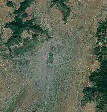
Imphal ([ɪmˈfɑl] (![]() listen)) is the capital city of the Indian state of Manipur. The metropolitan centre of the city contains the ruins of Kangla Palace (also known as Kangla Fort), the royal seat of the former Kingdom of Manipur, surrounded by a moat. Spread over parts of the districts of Imphal West and Imphal East, the former contains the majority of the city's area and population.[1] Imphal is part of the Smart Cities Mission under the Ministry of Housing and Urban Affairs.[2]
listen)) is the capital city of the Indian state of Manipur. The metropolitan centre of the city contains the ruins of Kangla Palace (also known as Kangla Fort), the royal seat of the former Kingdom of Manipur, surrounded by a moat. Spread over parts of the districts of Imphal West and Imphal East, the former contains the majority of the city's area and population.[1] Imphal is part of the Smart Cities Mission under the Ministry of Housing and Urban Affairs.[2]
Imphal
imphal | |
|---|---|
Capital City | |
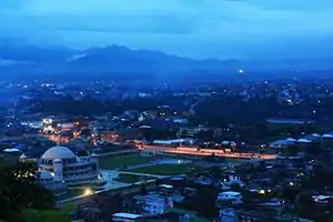
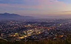 Skyline of Imphal | |
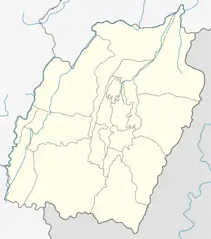 Imphal Location of Imphal in Manipur  Imphal Imphal (India) | |
| Coordinates: 24.8074°N 93.9384°E | |
| Country | |
| State | Manipur |
| District | Imphal East, Imphal West |
| Government | |
| • Body | Imphal Municipal Corporation |
| • Mayor | L. Lokeshwor Singh |
| Elevation | 786 m (2,579 ft) |
| Population (2011) | |
| • Total | 268,243 |
| Languages | |
| • Official | Meeteilon (Manipuri) and English |
| Time zone | UTC+5:30 (IST) |
| PIN | 795001 |
| Telephone code | 3852 |
| Vehicle registration | MN-01 |
| Website | imc |
History
Initially ruled by Kin Khaba, Imphal was later ruled by the Pakhangba leaders. The clan of the Ningthouja tribe originated then. The Ningthouja tribe quickly expanded and dominated the region in politics and war. Kangla Palace was built by King Khagemba and his son Khunjaoba. The palace was later destroyed by the British during the Anglo-Manipur War. During the reign of Maharaja Bhagyachandra, there were a number of Burmese invasions. However, the kingdom survived with the help of Maharaj Gambhir Singh.
Imphal remained peaceful until 1891 when the British arrived to intervene in internal differences between the royal family. The British sent J.W. Quinton to help but the situation only grew worse and Senapati Tikendrajit was hanged. The autocratic British behavior made people angry. This resulted in the 1891 Anglo-Manipur War, which the British won.[3]
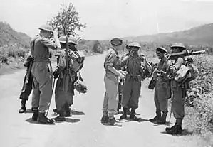
The Battle of Imphal took place between March and July 1944, during World War II. The Japanese invaded Imphal to capture British Colonies. However, they were defeated and had to retreat. This attack made the British realise the militarily strategic position of Imphal.[4]
Demographics
Imphal city is divided between the two districts of Imphal West and Imphal East.[1] Census collects the information for the two parts of the city separately, with the major portion of the city being in Imphal West and the minor portion in Imphal East.[5][6]
| Area | District | Total Population | Sex Ratio | Literacy Rate | Percentage of Scheduled Caste Population | Percentage of Scheduled Tribe Population |
|---|---|---|---|---|---|---|
| Imphal ( Major part) | West Imphal | 1,93,459 | 1048 | 91.7% | 0.56% | 8.59% |
| Imphal ( Minor part) | East Imphal | 83,737 | 1062 | 88.71% | 0.24% | 15.71% |
Geography and climate
| Imphal | ||||||||||||||||||||||||||||||||||||||||||||||||||||||||||||
|---|---|---|---|---|---|---|---|---|---|---|---|---|---|---|---|---|---|---|---|---|---|---|---|---|---|---|---|---|---|---|---|---|---|---|---|---|---|---|---|---|---|---|---|---|---|---|---|---|---|---|---|---|---|---|---|---|---|---|---|---|
| Climate chart (explanation) | ||||||||||||||||||||||||||||||||||||||||||||||||||||||||||||
| ||||||||||||||||||||||||||||||||||||||||||||||||||||||||||||
| ||||||||||||||||||||||||||||||||||||||||||||||||||||||||||||
Imphal is located at 24.8074°N 93.9384°E in extreme eastern India,[8] with an average elevation of 786 metres (2,579 ft). It has a humid subtropical climate (Köppen Cwa)[9] with mild, dry winters and a hot monsoon season. Temperatures in July average about 29 °C (84 °F); January is the coldest month, with average lows near 4 °C (39 °F). The city receives about 1,320 mm (52 in) of rain, with June the wettest month. The highest recorded temperature was 35.6 °C (96.1 °F), on 22 May 2009, and the lowest temperature was −2.7 °C (27.1 °F) on 10 January 1970.[7][10]
| Month | Jan | Feb | Mar | Apr | May | Jun | Jul | Aug | Sep | Oct | Nov | Dec | Year |
|---|---|---|---|---|---|---|---|---|---|---|---|---|---|
| Record high °C (°F) | 27.8 (82.0) |
32.0 (89.6) |
35.0 (95.0) |
34.5 (94.1) |
35.6 (96.1) |
35.6 (96.1) |
35.7 (96.3) |
34.0 (93.2) |
34.5 (94.1) |
34.2 (93.6) |
30.7 (87.3) |
28.9 (84.0) |
35.7 (96.3) |
| Average high °C (°F) | 22.4 (72.3) |
24.2 (75.6) |
27.2 (81.0) |
28.5 (83.3) |
29.2 (84.6) |
29.6 (85.3) |
29.4 (84.9) |
29.7 (85.5) |
29.5 (85.1) |
28.7 (83.7) |
25.9 (78.6) |
22.9 (73.2) |
27.3 (81.1) |
| Average low °C (°F) | 4.6 (40.3) |
7.7 (45.9) |
12.1 (53.8) |
15.8 (60.4) |
18.7 (65.7) |
21.3 (70.3) |
21.9 (71.4) |
21.7 (71.1) |
20.6 (69.1) |
17.2 (63.0) |
11.1 (52.0) |
6.1 (43.0) |
14.9 (58.8) |
| Record low °C (°F) | −2.7 (27.1) |
−1.4 (29.5) |
2.4 (36.3) |
6.2 (43.2) |
11.1 (52.0) |
14.7 (58.5) |
15.4 (59.7) |
14.6 (58.3) |
14.3 (57.7) |
7.8 (46.0) |
1.5 (34.7) |
−1.7 (28.9) |
−2.7 (27.1) |
| Average rainfall mm (inches) | 11.5 (0.45) |
43.4 (1.71) |
81.2 (3.20) |
154.6 (6.09) |
174.3 (6.86) |
221.6 (8.72) |
231.4 (9.11) |
186.8 (7.35) |
157.2 (6.19) |
122.3 (4.81) |
34.7 (1.37) |
17.8 (0.70) |
1,436.7 (56.56) |
| Average rainy days | 1.1 | 3.3 | 6.1 | 10.3 | 11.8 | 15.4 | 16.1 | 12.9 | 10.2 | 7.3 | 2.4 | 1.0 | 97.9 |
| Average relative humidity (%) (at 17:30 IST) | 60 | 54 | 53 | 62 | 69 | 77 | 79 | 79 | 80 | 78 | 74 | 70 | 70 |
| Source: India Meteorological Department[11][12][13] | |||||||||||||
Government and politics
Imphal is the state capital as well as the headquarters of the Imphal district. The civic administration of the city is under Imphal Municipal Corporation.
Civic administration
According to Census 2011, Imphal constitutes 42.13% of the total urban population in Manipur. Hence, the history of urban local governance is longer in Imphal than in other parts of the state. The British established the Town Fund Board in Imphal in 1915, which was headed by the then Political Agent Lt. Col. H.W.G. Cole and other nominated members.[14] The Town Fund Board continued after Independence and merger with India in 1949 and it was not headed by the Chief Secretary of Manipur Administration. In 1956, the Assam Municipal Act, 1923 was extended to Manipur and the Imphal Municipal Board was formed with 12 elected members. The strength of the elected members of this Board was increased to 24 in 1961 and to 28 in 1972.[15] Initially, the Municipal Board was established only to administer the areas in Imphal under the British Reserve, covering 3.10 km2 (1.20 sq mi) and 2,862 inhabitants. This was extended to 17.48 km2 (6.75 sq mi) in 1960, 18.25 km2 (7.05 sq mi) in 1970, and 76.58 km2 (29.57 sq mi) in 1972.[14]
In 1992, the Municipal Board was upgraded to a Municipal Council under the Manipur Municipality Act, 1994.[16] In 2014, the council was upgraded to the status of Municipal Corporation. There are 27 wards under the Municipal Corporation, each with its own elected councillor. There are eight committees and five sections at the corporation to govern the administration of the city.[17]
There are Ward Development Committees in each ward to look after developmental activities at the ward level. The local ward councillor is the chairperson of the committee, which includes two elected and two nominated members as well.[16] The last election to the corporation was in 2016, with INC winning 12 seats, BJP winning 10 seats, and independent candidates winning 5 seats.[18] According to the Manipur Municipality Act, 1994, the mayor is indirectly elected by the elected councillors from amongst themselves.[19] The first mayor of the corporation was Soram Sunil and was elected in 2016.[20] The present mayor of Imphal Municipal Corporation is Laisangbam Lokeshwar and was elected to the position in 2017. Sujata Phaomei is the present Deputy Mayor.[21]
Representation in parliament
Manipur is divided into two constituencies for the purpose of Lok Sabha - Outer Manipur Parliamentary Constituency and Inner Manipur Parliamentary Constituency. Imphal city is part of the Inner Manipur Parliamentary Constituency.[22] The last elections took place during the 2019 Indian general elections. Rajkumar Ranjan Singh from the Bharatiya Janata Party won the election with 2,63,632 votes.[23]
Civic amenities
Manipur State Power Distribution Company Limited is responsible for electricity supply in the city.[24] Public Health and Engineering Department of the Manipur Government looks after both water supply, and sewage and drainage in Imphal.[25] Roads in the city are developed and maintained by the state Public Works Department.[26] Imphal Municipal Corporation is responsible for Solid Waste Management.[27] The state Department of Fire Services provides fire safety services in the city with one fire station, which is also the department headquarters.[28]
Tourist attractions
Imphal offers sites of religious and historical importance within and around the city. Kangla Palace (also known as Kangla Fort) is on the banks of the Imphal River. Kangla means "dry land" in the Meitei language. It was the palace of King Pakhangba, and has religious significance with multiple temples present within the complex.[29] It is also significant in Manipur's history with the British.[30] Bihu Loukon is an ancient star-shaped fort made of mud situated in Maklang, Imphal West District. It was discovered in 2013.[31] Hiyangthang Lairembi Temple is religious site important to both the local religion, Sanamahism, and to Hinduism. The temple is noted for its annual Durga Puja festival.[32]
India Peace Memorial at the Red Hills is located }}cvt|12|km}} south of Imphal. The place was the scene of action and the theater of the battle that took place between the British Army and the Japanese Forces[33] fighting alongside the Indian National Army in World War II.[34] Red Hill has now become a tourist attraction since the Japanese war veterans constructed a monument at the foot of this hill.[35] The Imphal War Cemetery remembers Indian and British soldiers who fought and died in 1944 during World War II and is managed by the Commonwealth War Graves Commission.[36]
Imphal is also home to the largest all women run market in Asia, called the Ima Keithel (Mothers' Market).[37] It was established in the 16th century and hosts around 5,000–6,000 women vendors who sell a variety of products.[38][39]
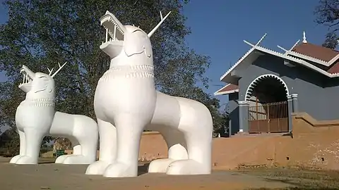 A pair of Kangla Sha dragons at Kangla Fort
.jpeg.webp) Bamboo huts in Kangla Fort complex
Bamboo huts in Kangla Fort complex Kangla Fort Complex
.jpeg.webp) Ruins of Kangla Fort
Ruins of Kangla Fort.jpeg.webp) Kangla Museum houses
Kangla Museum houses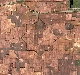 Bihu Loukon aerial view
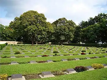 Imphal War Cemetery
.jpeg.webp) Women's Market (Ima Keithel)
Women's Market (Ima Keithel)
Transport
Air
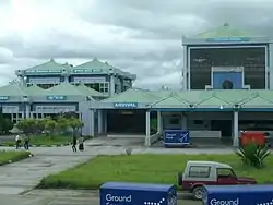
Tulihal International Airport is 8 kilometres (5.0 mi) south of the city and has direct flights to major Indian cities.[40]
Road
.jpeg.webp)
Imphal is connected by the National Highway to major cities like Guwahati, Kohima, Agartala, Shillong, Dimapur, Aizawl, and Silchar.
Railway
In October 2012, India's Cabinet Committee on Infrastructure approved an extension of the Jiribam–Silchar railway to Imphal. The extension was expected to reach the city by 2019.[41][42] The total length of the railway line is 110.62 km. The revised estimated cost of construction for the railway line sits at Rs 9658 crore, with Rs 4927.54 crore being spent as of 2019.
Sports
Khuman Lampak Main Stadium is a multi-purpose stadium in Imphal. It is used mostly for football and athletics. The stadium holds 30,000 people and was built in 1999. This stadium lies inside the Khuman Lampak Sports Complex. The professional football club NEROCA FC and TRAU FC of I League uses the stadium as their home ground.
Education
Universities

Technical colleges
Medical colleges
Schools
There are many schools in Imphal affiliated with the Central Board of Secondary Education and Indian Certificate of Secondary Education Board, as well as state government schools.
- Areca School, Ragailong
- Comet School, Changangei
- Dav Public School, Chingmeirong
- Don Bosco School Imphal, Chingmeirong
- Guru Nanak Public School
- Herbert School
- Jawahar Navodaya Vidyalaya including Khumbong (Imphal west), Imphal east, Bishnupur, CCpur, Ukrul, Thoubal, Tamenglong and Senapati
- Johnstone Higher Secondary Public School
- Kids' Foundation School, Ghari
- Maria International Montessori School, Koirengei
- Kendriya Vidyalaya No 1 Imphal, Lamphelpat
- Kendriya Vidyalaya No 2 Imphal, Langjing
- Little Flower School
- Lodestar Public School
- Manipur Public School
- Sainik International School & College Imphal
- St. Anthony's English School & College Imphal
- St. John English High School, Nambol, Bishnupur District
- St. Joseph School
- St. Paul's English School
- Sanfort International School & College Imphal
- Sangai Higher Secondary Public School
Healthcare
Imphal has many private and government hospitals that are open 24 hours.
- Regional Institute of Medical Sciences
- Shija Hospitals & Research Institutes
- City Hospital
- Imphal Hospital
- Raj Medicity
- Sky Hospital and Research Institute
- Mother's Care Hospital and Research Centre
- Apex Hospital
- Jawaharlal Nehru Institute of Medical Sciences
- Horizon Hospital and Research Institute
- Advanced Hospital
- Catholic Medical Centre
- Maipakpi Maternity and Child Hospital
- Iboyaima Hospital
- City Hospital
Notable people
- M. K. Binodini Devi, novelist, short story writer, playwright and a member of the royal family of Manipur
- Yumlembam Gambhini Devi, recipient of the 1988 Sangeet Natak Akademi Award and the 2005 fourth highest civilian honour, the Padma Shri, for her contributions to Manipuri dance and music
- Ngairangbam Bijoy Singh, doctor and politician
- Ratan Thiyam, theatre director and chairman of the Chorus Theatre Imphal, former chairman at National School of Drama
- Neelamani Devi, craftswoman and master potter who was awarded the Padma Shri in 2007 for her contributions to the art of pottery making
- Mary Kom, boxer and national representative at world sport events
- Dingko Singh, boxer who won a gold medal at the 1998 Asian Games in Bangkok and was awarded the Padma Shri in 2013
- Binalakshmi Nepram, humanitarian, author, and female activist for gender rights and women-led disarmament movements in Manipur and northeast India
- Irom Chanu Sharmila, also known as the "Iron Lady" or "Mengoubi" ("the fair one"), a civil rights activist, political activist, and poet
- Robert Naorem, designer representative of indigenous designs of Manipur and involved in the Hindi film industry
- Dheeraj Singh Moirangthem, footballer
- Bombayla Devi Laishram, archer who was awarded the Arjuna Award in 2012 and the Padma Shri in 2019 by the Government of India for her contributions to sports
- Armstrong Pame, Indian Administrative Service officer from Tamenglong
See also
References
- "Simply put: Seven new districts that set Manipur ablaze". The Indian Express. 20 December 2016. Retrieved 15 October 2020.
- "Imphal Smart City Limited". Retrieved 16 October 2020.
- "History of Imphal - Imphal History". iloveindia.com. Retrieved 22 February 2020.
- "Imphal and Kohima". Britain's Greatest Battles. National Army Museum. Archived from the original on 7 February 2015. Retrieved 9 January 2016.
- "District Census Handbook: Imphal East" (PDF). Census India. Retrieved 15 October 2020.
- "District Census Handbook: Imphal West" (PDF). Census India. Retrieved 15 October 2020.
- "Imphal, India". India Meteorological Department. Archived from the original on 15 December 2018. Retrieved 16 May 2014.
- "Maps, Weather, and Airports for Imphal, India". Retrieved 10 June 2015.
- "Climate: Imphal - Climate graph, Temperature graph, Climate table". Climate-Data.org. Retrieved 31 October 2013.
- "Ever Recorded Maximum Temperature, Minimum Temperature and 24 Hours Heaviest Rainfall upto 2010" (PDF). India Meteorological Department. Archived from the original (PDF) on 21 May 2013. Retrieved 16 May 2014.
- "Station: Imphal/Tulihal (A) Climatological Table 1981–2010" (PDF). Climatological Normals 1981–2010. India Meteorological Department. January 2015. pp. 335–336. Archived from the original (PDF) on 5 February 2020. Retrieved 5 February 2020.
- "Extremes of Temperature & Rainfall for Indian Stations (Up to 2012)" (PDF). India Meteorological Department. December 2016. p. M156. Archived from the original (PDF) on 5 February 2020. Retrieved 5 February 2020.
- "Imphal Climatological Table 1971–2000". India Meteorological Department. Retrieved 5 February 2020.
- Lairenlakpam, Bino Devi (22 April 2015). "Development and working of the Imphal Municipal Board from 1956 to 1980". Shodhganga. hdl:10603/39465. Retrieved 9 September 2020.
- "Chapter VIII, City Utility Services" (PDF). Shodhganga. Retrieved 15 September 2020.
- "State Annual Action Plan (SAAP) for Imphal, Manipur, FY 2015-16" (PDF). Atal Mission for Rejuvenation and Urban Transformation. Retrieved 15 September 2020.
- "Organisational Structure" (PDF). Imphal Municipal Corporation. Retrieved 15 September 2020.
- Indo-Asian News Service (7 June 2016). "Congress wins 12 seats in 27-member Manipur local body". Business Standard. Retrieved 15 September 2020.
- "Manipur Municipalities Act, 1994" (PDF). Imphal Municipal Corporation. Retrieved 15 September 2020.
- 18 Jun, TNN /; 2016; Ist, 05:37. "Soram Sunil sworn in as first mayor of Imphal | Imphal News - Times of India". The Times of India. Retrieved 15 September 2020.CS1 maint: numeric names: authors list (link)
- "IMC Mayor : 10th jun17 ~ E-Pao! Headlines". e-pao.net. Retrieved 15 September 2020.
- "Parliamentary Constituencies | Imphal West District, Government of Manipur | India". Retrieved 15 October 2020.
- S, Vangamla Salle K. "BJP's Rajkumar Ranjan, NPF's Lorho S Pfoze win Manipur LS seats". EastMojo. Retrieved 15 October 2020.
- "Home". Manipur State Power Distribution Company Limited. Retrieved 15 October 2020.
- "Home". Public Health and Engineering Department. Retrieved 15 October 2020.
- "Home". Public Works Department, Government of Manipur. Retrieved 15 October 2020.
- Mahongnao, Mirinchonme (20 February 2017). "URBAN SOLID WASTE MANAGEMENT IN IMPHAL, MANIPUR". Journal of Industrial Pollution Control. 33 (1): 696–701. ISSN 0970-2083.
- "FIRE STATION LIST « Official Website Manipur Fire Servcie". manipurfireservice.gov.in. Retrieved 15 October 2020.
- "Who's who 1891 of Manipur state archives". archivesmanipur.nic.in. Retrieved 19 October 2020.
- "Who's who 1891 of Manipur state archives". archivesmanipur.nic.in. Retrieved 19 October 2020.
- Press, Imphal Free. "Ancient star shaped mud fort discovered at Maklang, Manipur – KanglaOnline". Retrieved 19 October 2020.
- Admin), Jitendra(. "Thousands of devotees throng Hiyangthang Lairembi Temple on the day of Bor on second day of Durga Puja Festival - Impact TV - The Official Website". impacttv.in. Retrieved 19 October 2020.
- Admin), William(. "May 10, 1942: first bomb hit Imphal in World War 2".
- Milaap (27 August 2019). "Footprints of the Past: A Visit To India Peace Memorial". SheThePeople TV. Retrieved 19 October 2020.
- bureau, Odisha Diary (26 January 2018). "The India Peace Memorial at Lokpaching, Imphal". Odisha Breaking News | Odisha News | Latest Odisha News| Odisha Diary. Retrieved 19 October 2020.
- "Cemetery Details | CWGC". www.cwgc.org. Retrieved 19 October 2020.
- "3-storey market building coming up at Pureiromba Keithel in Imphal". NORTHEAST NOW. Retrieved 19 October 2020.
- "Incredible India | Ima Keithel/ Ima Market/ Khwairamband Bazar". www.incredibleindia.org. Retrieved 19 October 2020.
- Chakravarty, Ipsita. "The earthquake has damaged a nerve centre of life in Manipur: the Ima Keithel or Mother's Market". Scroll.in. Retrieved 19 October 2020.
- "Imphal". Airports Authority of India. Archived from the original on 9 October 2012. Retrieved 25 November 2012.
- "Govt approves rail link to Imphal". The Indian Express. 26 October 2012. Retrieved 25 November 2012.
- "NFR – Jiribam-Imphal Rail Line – Manipur". Construction Intelligence Centre. Archived from the original on 19 January 2018. Retrieved 7 November 2017.
- "Manipur University". Archived from the original on 1 June 2015. Retrieved 10 June 2015.
- "Welcome To NIT Manipur". Retrieved 10 June 2015.
- "MTU". mtu.ac.in. Retrieved 25 February 2017.
- "Regional Institute of Medical Sciences". Retrieved 28 January 2014.
- "JNIMS". Archived from the original on 22 November 2010. Retrieved 28 January 2014.
External links
 Imphal travel guide from Wikivoyage
- Imphal West
- Imphal East
| Wikimedia Commons has media related to Imphal. |
| State symbols | |
|---|---|
| Topics | |
| Languages | |
| Administration |
|
| Districts | |
| Municipal Corporation | |
| Municipalities | |
| Proposed Municipalities | |
| Town Councils | |
| Minor Townships | |
| Sport | |
| Authority control |
|---|