Churachandpur district
Churachandpur District is one of the 16 districts in the southwestern corner of the Indian state of Manipur that covers an area of 4,750 kilometres (2,950 mi). Churachandpur District, previously known as Manipur South District[2] came into existence in the year 1969 along with the district reorganization of Manipur.[3]
Churachandpur District | |
|---|---|
District | |
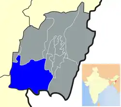 Location of Churachandpur district in Manipur | |
| Coordinates: 24°20′N 93°41′E | |
| Country | |
| State | Manipur |
| District | Churachandpur |
| Headquarters | Churachandpur |
| Area | |
| • Total | 4,750 km2 (1,830 sq mi) |
| Area rank | 1 (of 9) |
| Elevation (District headquarters) | 914.4 m (3,000.0 ft) |
| Population (2011)[1] | |
| • Total | 300,000+ |
| • Rank | 5 (of 9) |
| • Density | 59/km2 (150/sq mi) |
| • Percent of state | 9.97%[1] |
| Literacy (2001) | |
| • Literacy Rate | 84.29%[1] (Rank 2/9) |
| • Literacy by gender | |
| Time zone | UTC+5:30 (IST) |
| PIN | 795128 (CCPur),
795006 (New Lamka CCPur) |
| Telephone code | 03874 |
| Vehicle registration | MN |
| Sex ratio | 969 females per 1000 males[1] |
| Website | churachandpur |
Tuibuong is the headquarters of (Churachandpur) District. Lamka Town is the biggest town in Churachandpur District and also in the state of Manipur
Demographics
The district is inhabited by several Kuki -Chin-Mizo- Zomi people. More recently the meiteis and meitei-pangans have started settling in the district. As of the 2011 census, Churachandpur district had a population of 271,274,[4] roughly equal to that of Barbados.[5] This gives it a ranking of 575th in India (out of a total of 640 districts).[4] It has a population density of 59 inhabitants per square kilometre (150/sq mi).[4] Its population growth rate over the decade 2001–2011 was 19.03%.[4] Churachandpur has a sex ratio of 969 females for every 1000 males,[4] and a literacy rate of 84.29%.[4]
Languages
Major languages spoken are Thadou, Paite, Hmar, Vaiphei, Lusei (Mizo), Zou, Simte, Gangte, Kom, Aimol, Thangkhal/Mate, Chothe etc. Their languages are close and they can understand each other. There are so sub-dialects within each of these languages. Apart from the local languages English, Hindi and Manipuri (Meitei) are also used.
Educational facilities
Private
Bethesda School of Nursing, Mualvaiphei [8]
Tunnu School Of Nursing [9]
Young Pillars College
Private Universities
Health
Churachandpur District Hospital is located within the Lamka town. Initially it was a Dispensary with few staffs and in the year 1968 it became a 50 bedded Civil Hospital which was inaugurated by Shri Baleswar Prasad, Chief Commissioner of Manipur on 8/6/1968. The hospital was extended with another 50 bedded new building inaugurated on 17 May 1985 by the Medical Minister Shri T. Phungzathang Tonsing and became a 100 bedded one. The present Building OPD block was inaugurated on 31/05/2002 and O.T wing on 23/12/2013 and lastly the Trauma Centre on 19/07/2014 by the Hon’ble Chief Minister in presence of Health Minister and Industries Minister. The Government of Manipur approved upgrading the hospital to 200 bedded ward and start the process of making it a Hill Medical College under the leadership of Hon’ble Medical Minister.[11]
Economy
The Gross Domestic Product(GDP) and Per Capita Income(PCI) are still low due to dominant agriculture and traditional economic activities. However, there is huge changes in recent times. Micro, small and medium enterprises slowly penetrate the main business town since the past decades mainly due to better road connectivity and entrepreneurial spirit of the community.
In 2006 the Ministry of Panchayati Raj named Churachandpur one of the country's most impoverished districts (out of a total of 640).[12] It is one of the three districts in Manipur currently receiving funds from the Backward Regions Grant Fund (BRGF).[12]
Reputed financial institutions has its presence in the district. State Bank of India (SBI), United Bank of India (UBI), Canara Bank, Vijaya Bank, Axis Bank, UCO Bank, Manipur Rural Bank, Co-operative Bank, Central Bank of India and ICICI set up their branches at various locations. SBI with its four branches within the district is the largest bank with the maximum footfall.
Climate
The location is north of Tropic of Cancer in northern hemisphere, it has summer season in March, April and May with warm, hot and sunny weather. Rainy season starts April and last till October. The winter season is cool and dry.
| Climate data for Lamka[13] | ||||||||||||
| Month | Jan | Feb | Mar | Apr | May | Jun | July | Aug | Sep | Oct | Nov | Dec |
| High °C | 27 | 28 | 36 | 36 | 34 | 39 | 37 | 39 | 38 | 34 | 32 | 28 |
| Low °C | 7 | 4 | 14 | 18 | 21 | 22 | 24 | 25 | 22 | 19 | 16 | 8 |
Transportation
Airport
Nearest airport from Churachandpur is Imphal Airport at Imphal which is about 60 km.
Media
The major private television channels/cables are Angels Vision Digital Cable, Hornbill Cable Network, TC Network and Tullou TV.
Manipur Express and Lamka Post are Churachandpur's largest daily newspapers.
Government, Politics and Administration
Administration is carried out by the Deputy Commissioners or District Magistrates with support of the District level officer and Block Development officers. The district collector office is located at Tuibuong.
The administrative setup of Churachandpur District.[14]
- Sub Divisions & Blocks
- Autonomous District Councils
- Towns
- Police Stations
- Assembly Constituencies
Autonomous district council
At the district level there is the Churachandpur Autonomous District Council created by "The Manipur (Hill Areas) District Council Act, 1971,” passed by Parliament. The Autonomous District Council is to administer areas which have been given autonomy within the states under Manipur (Hill Areas) District Councils Act, 1971. In accordance with this Act Autonomous (Hill) District Council is empowered to maintain and manage of property: movable and immovable, and institutions under their jurisdiction.[15] Churachandpur Autonomous District Council has 24 constituencies.[16]
References
- "Census of India: Provisional Population Totals and Data Products – Census 2011: Manipur". Office of the Registrar General and Census Commissioner, Ministry of Home Affairs, Government of India. 2011. Retrieved 1 June 2011.
- "History | Churachandpur District, Government of Manipur | India". Retrieved 4 December 2020.
- "About District | Churachandpur District, Government of Manipur | India". Retrieved 7 February 2020.
- "District Census 2011". Census2011.co.in. 2011. Retrieved 30 September 2011.
- US Directorate of Intelligence. "Country Comparison: Population". Retrieved 1 October 2011.
Barbados 286,705 July 2011 est.
- "Rayburn College – Learn | Labor | Serve". Retrieved 7 February 2020.
- "GBC | Teach, Entrust & Witness". Grace Bible College | Teach, Entrust & Witness. Retrieved 7 February 2020.
- "Recognised Institute (MNC)". Retrieved 9 December 2020.
- "List of State Nursing Council Recognised Institutions offering GNM Programme Inspected Under Section 13 and 14 of INC Act" (PDF). Retrieved 27 December 2020.
- "Churachandpur College". www.churachandpurcollege.in. Retrieved 7 February 2020.
- "Scheme for Strengthening of Drug De-Addiction Services". www.dtc-scheme.in. Retrieved 6 February 2018.
- Ministry of Panchayati Raj (8 September 2009). "A Note on the Backward Regions Grant Fund Programme" (PDF). National Institute of Plural Development. Archived from the original (PDF) on 5 April 2012. Retrieved 27 September 2011.
- "Weather".
- "administrative set-up of the district".
- "Administration of Hill Areas (Tribal areas)" (PDF).
- "ADC constituencies of Churachandpur (Lamka)" (PDF).
- The history and land-holding behind Manipur South District with Special Reference to the Haokip Reserved Land- 1907, T.S Letkhosei Haokip (Manipur University).
- Chinkhopau (1995) Churachandpur District, Churachandpur: Published by Author.
- District Statistical Handbook – Churachandpur: District Statistical Officer.
- Gangte, Thangzam (undated) Churachandpur Chanchin (An Account of Churachandpur)
- Ginsum, H (undated) Lamka Vangkhua (Lamka Town).
- Kamkhenthang, Dr. H (1995) "Lamka Town vis-a-vis Churachandpur", Shan (daily), 21 December.
- Kamkhenthang (1998) "Lamka (Churachandpur)" in B.D. Ray, A.K. Neog & H.K. Mazhari (eds.) Urban Development in North-East India : Potentiality and Problems, New Delhi: Vedams Books.
- Manipur State Archives, Imphal: Manipur State Durbar 1907–1947 – Papers related to the Court of the President of Manipur State Durbar, Hill Misc. Case No. 28 of 1945–46, Phungkhothang Chief of Hiangtam Lamka; also Misc Case No. 504 of 1934 Phungkhothang Chief of Hiangtam Lamka.
External links
Places adjacent to Churachandpur district | ||||||||||
|---|---|---|---|---|---|---|---|---|---|---|
| ||||||||||
| State symbols | |
|---|---|
| Topics | |
| Languages | |
| Administration |
|
| Districts | |
| Municipal Corporation | |
| Municipalities | |
| Proposed Municipalities | |
| Town Councils | |
| Minor Townships | |
| Sport | |