Rock County, Minnesota
Rock County is a county at the southwestern corner of the U.S. state of Minnesota. As of the 2010 census, the population was 9,687.[1] Its county seat is Luverne.[2]
Rock County | |
|---|---|
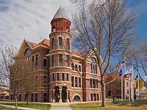 Rock County Courthouse | |
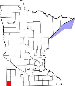 Location within the U.S. state of Minnesota | |
 Minnesota's location within the U.S. | |
| Coordinates: 43°40′N 96°15′W | |
| Country | |
| State | |
| Founded | May 23, 1857 (created) March 5, 1870 (organized) |
| Named for | Rock outcrop on Rock River |
| Seat | Luverne |
| Largest city | Luverne |
| Area | |
| • Total | 483 sq mi (1,250 km2) |
| • Land | 482 sq mi (1,250 km2) |
| • Water | 0.3 sq mi (0.8 km2) 0.06%% |
| Population (2010) | |
| • Total | 9,687 |
| • Estimate (2019) | 9,315 |
| • Density | 19.7/sq mi (7.6/km2) |
| Time zone | UTC−6 (Central) |
| • Summer (DST) | UTC−5 (CDT) |
| Congressional district | 1st |
| Website | www |
History
The county was formed on May 23, 1857 by act of the territorial legislature, but was not organized at that time. The area was designated Pipestone County, and the name Rock County was attached to the present Pipestone. In 1862 the Minnesota state legislature changed the designations, attaching the present names to the present counties. On March 5, 1870, the state legislature approved an act that finalized the county's organization and designated Luverne as the county seat. The county's name came from the Rock River, which in turn is named for a prominent rocky outcrop (designated "The Rock" on an 1843 map of the area) of reddish-gray quartzite, about 3 miles (5 km) north of Luverne. The mound dramatically contrasts with the low surrounding prairie.[3] Another source attributes the county name to its rocky soil.[4]
Geography
Rock County lies at Minnesota's southwest corner. Its western border abuts South Dakota's eastern border; its southern border abuts Iowa's northern border. The Rock River flows southward through the east central part of the county, and Beaver Creek flows southward through the west central part of the county. The county consists of low rolling hills carved with drainages. The area is devoted to agriculture.[5] The terrain slopes to the south, with its highest point near the midpoint of its north boundary, at 1,759' (536m) ASL.[6] The county has an area of 483 square miles (1,250 km2), of which 482 square miles (1,250 km2) is land and 0.3 square miles (0.78 km2) (0.06%) is water.[7] The entire county falls in the hot summer humid continental climate zone (Dfa).
Lakes
One of Minnesota's nicknames is "Land of 10,000 Lakes", and it is speckled with bodies of water large and small. But four of the state's counties do not contain a natural lake; Rock County is one of them.[9] Rock County did host a manmade lake from 1938 until 2014: a WPA work project constructed a small dam (the "Lower Dam") on Blue Mounds Creek in 1938, creating a small lake in Blue Mounds State Park. This continued until June 2014, when the dam was damaged by rain and floodwaters, allowing the pond to drain.[10] In June 2016 the Minnesota Division of Natural Resources announced its decision not to rebuild the dam.[11]
Major highways
Adjacent counties[6]
- Pipestone County – north
- Murray County – northeast
- Nobles County – east
- Lyon County, Iowa – south
- Minnehaha County, South Dakota – west
- Moody County, South Dakota – northwest
Protected areas[5]
Demographics
| Historical population | |||
|---|---|---|---|
| Census | Pop. | %± | |
| 1860 | 23 | — | |
| 1870 | 138 | 500.0% | |
| 1880 | 3,669 | 2,558.7% | |
| 1890 | 6,817 | 85.8% | |
| 1900 | 9,668 | 41.8% | |
| 1910 | 10,222 | 5.7% | |
| 1920 | 10,965 | 7.3% | |
| 1930 | 10,962 | 0.0% | |
| 1940 | 10,933 | −0.3% | |
| 1950 | 11,278 | 3.2% | |
| 1960 | 11,864 | 5.2% | |
| 1970 | 11,346 | −4.4% | |
| 1980 | 10,703 | −5.7% | |
| 1990 | 9,806 | −8.4% | |
| 2000 | 9,721 | −0.9% | |
| 2010 | 9,687 | −0.3% | |
| 2019 (est.) | 9,315 | [12] | −3.8% |
| US Decennial Census[13] 1790-1960[14] 1900-1990[15] 1990-2000[16] 2010-2019[1] | |||

2000 census
As of the 2000 United States Census,[17] there were 9,721 people, 3,843 households, and 2,705 families in the county. The population density was 20.2/sq. mi. (7.79/km2). There were 4,137 housing units at an average density of 8.58/sqmi (3.31/km2). The racial makeup of the county was 97.27% White, 0.53% Black or African American, 0.43% Native American, 0.62% Asian, 0.02% Pacific Islander, 0.53% from other races, and 0.59% from two or more races. 1.28% of the population were Hispanic or Latino of any race. 41.4% were of German, 23.8% Dutch and 16.5% Norwegian ancestry.
There were 3,843 households, out of which 31.30% had children under the age of 18 living with them, 62.10% were married couples living together, 5.50% had a female householder with no husband present, and 29.60% were non-families. 27.00% of all households were made up of individuals, and 15.70% had someone living alone who was 65 years of age or older. The average household size was 2.47 and the average family size was 3.01.
The county population contained 26.30% under the age of 18, 7.20% from 18 to 24, 24.10% from 25 to 44, 22.00% from 45 to 64, and 20.40% who were 65 years of age or older. The median age was 40 years. For every 100 females there were 97.60 males. For every 100 females age 18 and over, there were 93.00 males.
The median income for a household in the county was $38,102, and the median income for a family was $44,296. Males had a median income of $28,776 versus $22,166 for females. The per capita income for the county was $17,411. About 5.50% of families and 8.00% of the population were below the poverty line, including 8.10% of those under age 18 and 8.90% of those age 65 or over.
Communities
.svg.png.webp)
In popular culture
Much of the second season of Fargo is set in Luverne and Rock County.
Government and politics
| Position | Name | District | |
|---|---|---|---|
| Commissioner | Gary Overgaard | District 1 | |
| Commissioner | Stan Williamson | District 2 | |
| Commissioner | Greg Burger | District 3 | |
| Commissioner | Sherri Thompson | District 4 | |
| Commissioner | Jody Reisch | District 5 | |
| Position | Name | Affiliation | District | |
|---|---|---|---|---|
| Senate | Bill Weber[18] | Republican | District 22 | |
| House of Representatives | Joe Schomacker[19] | Republican | District 22A | |
| Position | Name | Affiliation | District | |
|---|---|---|---|---|
| House of Representatives | Jim Hagedorn[20] | Republican | 1st | |
| Senate | Amy Klobuchar[21] | Democrat | N/A | |
| Senate | Tina Smith[22] | Democrat | N/A | |
National politics
Rock County traditionally votes Republican. In no presidential election since 1964 has it selected the Democratic candidate. It and Pipestone County were the only Minnesota counties Amy Klobuchar did not win in her 2012 Senate race.[23]
| Year | Republican | Democratic | Third parties |
|---|---|---|---|
| 2016 | 63.9% 3,091 | 28.4% 1,373 | 7.7% 375 |
| 2012 | 58.0% 2,810 | 40.2% 1,946 | 1.9% 90 |
| 2008 | 55.8% 2,775 | 41.8% 2,079 | 2.4% 121 |
| 2004 | 59.9% 3,111 | 38.5% 2,000 | 1.5% 80 |
| 2000 | 55.3% 2,772 | 41.5% 2,081 | 3.1% 157 |
| 1996 | 44.2% 2,169 | 43.7% 2,142 | 12.1% 593 |
| 1992 | 38.7% 2,065 | 37.6% 2,006 | 23.7% 1,267 |
| 1988 | 52.5% 2,737 | 46.7% 2,435 | 0.8% 43 |
| 1984 | 57.2% 2,971 | 42.1% 2,188 | 0.7% 37 |
| 1980 | 55.4% 3,164 | 36.6% 2,089 | 8.1% 460 |
| 1976 | 50.4% 2,892 | 48.3% 2,769 | 1.4% 78 |
| 1972 | 61.8% 3,470 | 37.2% 2,089 | 0.9% 53 |
| 1968 | 56.9% 3,056 | 38.8% 2,084 | 4.4% 234 |
| 1964 | 45.2% 2,389 | 54.8% 2,896 | 0.0% 2 |
| 1960 | 65.5% 3,469 | 34.4% 1,823 | 0.1% 5 |
| 1956 | 67.2% 3,267 | 32.7% 1,591 | 0.1% 4 |
| 1952 | 74.5% 3,774 | 25.4% 1,286 | 0.1% 7 |
| 1948 | 48.1% 2,035 | 50.4% 2,134 | 1.5% 65 |
| 1944 | 60.7% 2,584 | 38.7% 1,649 | 0.6% 27 |
| 1940 | 59.5% 2,944 | 40.1% 1,983 | 0.5% 24 |
| 1936 | 36.2% 1,752 | 60.2% 2,910 | 3.6% 176 |
| 1932 | 34.6% 1,452 | 64.2% 2,695 | 1.3% 54 |
| 1928 | 60.0% 2,433 | 39.7% 1,607 | 0.3% 13 |
| 1924 | 52.0% 2,065 | 6.6% 261 | 41.5% 1,647 |
| 1920 | 84.5% 3,121 | 12.0% 442 | 3.5% 129 |
| 1916 | 59.7% 1,196 | 35.2% 705 | 5.1% 103 |
| 1912 | 25.6% 463 | 25.8% 466 | 48.7% 881 |
| 1908 | 67.2% 1,234 | 28.6% 525 | 4.2% 77 |
| 1904 | 79.1% 1,243 | 15.3% 241 | 5.5% 87 |
| 1900 | 65.2% 1,234 | 30.3% 573 | 4.5% 86 |
| 1896 | 59.9% 1,209 | 37.9% 765 | 2.3% 46 |
| 1892 | 59.6% 940 | 24.3% 383 | 16.1% 253 |
References
- "State & County QuickFacts". United States Census Bureau. Retrieved September 1, 2013.
- "Find a County". National Association of Counties. Retrieved June 7, 2011.
- Upham, Warren. Minnesota Geographic Names, p. 466 (1920). Accessed March 13, 2019
- Chicago and North Western Railway Company (1908). A History of the Origin of the Place Names Connected with the Chicago & North Western and Chicago, St. Paul, Minneapolis & Omaha Railways. p. 163.
- [ ]
- "Find an Altitude/Rock County MN" Google Maps (accessed March 13, 2019)
- "2010 Census Gazetteer Files". US Census Bureau. August 22, 2012. Archived from the original on September 21, 2013. Retrieved October 24, 2014.
- Nelson, Steven (2011) Savanna Soils of Minnesota. Minnesota: Self. pp. 69-70. ISBN 978-0-615-50320-2.
- The four counties lacking a natural lake are Mower, Olmsted, Pipestone, and Rock.
- "Luverne Dam Breaks, Drains Popular Lake". KELOLAND News. Retrieved February 5, 2018.
- "DNR Decides Not To Rebuld Blue Mounds State Park Dam" (Minnesota Natural Resources news release dated June 22, 2016). Accessed March 13, 2019
- "Population and Housing Unit Estimates". Retrieved March 26, 2020.
- "US Decennial Census". US Census Bureau. Retrieved October 24, 2014.
- "Historical Census Browser". University of Virginia Library. Retrieved October 24, 2014.
- "Population of Counties by Decennial Census: 1900 to 1990". US Census Bureau. Retrieved October 24, 2014.
- "Census 2000 PHC-T-4. Ranking Tables for Counties: 1990 and 2000" (PDF). US Census Bureau. Retrieved October 24, 2014.
- "U.S. Census website". US Census Bureau. Retrieved January 31, 2008.
- "MN State Senate". www.senate.mn. Retrieved June 25, 2020.
- "Rep. Joe Schomacker (22A) - Minnesota House of Representatives". www.house.leg.state.mn.us. Retrieved June 25, 2020.
- "Representative Jim Hagedorn". Representative Jim Hagedorn. Retrieved June 25, 2020.
- "U.S. Senator Amy Klobuchar". www.klobuchar.senate.gov. Retrieved June 24, 2020.
- "Home". Senator Tina Smith. Retrieved June 24, 2020.
- "Minnesota 2012 senate results by county". New York Times. Retrieved November 19, 2020.
- Leip, David. "Atlas of US Presidential Elections". uselectionatlas.org. Retrieved October 10, 2018.
External links
Places adjacent to Rock County, Minnesota | |
|---|---|
Municipalities and communities of Rock County, Minnesota, United States | ||
|---|---|---|
| Cities | Map of Minnesota highlighting Rock County | |
| Townships | ||
| Unincorporated communities | ||
| Ghost towns | ||
| Footnotes | ‡This populated place also has portions in an adjacent county or counties | |
| ||

| Authority control |
|---|