Mesnil-sur-l'Estrée
Mesnil-sur-l'Estrée is a commune in the Eure department in Normandy in northern France.
Mesnil-sur-l'Estrée | |
|---|---|
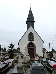 The church in Mesnil-sur-l'Estrée | |
Location of Mesnil-sur-l'Estrée 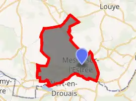
| |
 Mesnil-sur-l'Estrée  Mesnil-sur-l'Estrée | |
| Coordinates: 48°46′22″N 1°18′08″E | |
| Country | France |
| Region | Normandy |
| Department | Eure |
| Arrondissement | Évreux |
| Canton | Saint-André-de-l'Eure |
| Intercommunality | Évreux Portes de Normandie |
| Government | |
| • Mayor (2020–2026) | Fabrice Bossuyt[1] |
| Area 1 | 5.76 km2 (2.22 sq mi) |
| Population (2017-01-01)[2] | 904 |
| • Density | 160/km2 (410/sq mi) |
| Time zone | UTC+01:00 (CET) |
| • Summer (DST) | UTC+02:00 (CEST) |
| INSEE/Postal code | 27406 /27650 |
| Elevation | 83–139 m (272–456 ft) (avg. 132 m or 433 ft) |
| 1 French Land Register data, which excludes lakes, ponds, glaciers > 1 km2 (0.386 sq mi or 247 acres) and river estuaries. | |
It is one of many villages in the north of France bearing the name Estrées. The etymology of the name is from strata (cognate of English "street") which developed into "estrée" - the word for the stone-layered Roman roads in the area (some of which turned into modern highways). Hence "Mesnil-sur-l'Estrée", "Mesnil On The Road".
Population
| Year | Pop. | ±% |
|---|---|---|
| 1962 | 708 | — |
| 1968 | 753 | +6.4% |
| 1975 | 739 | −1.9% |
| 1982 | 764 | +3.4% |
| 1990 | 1,090 | +42.7% |
| 1999 | 1,031 | −5.4% |
| 2008 | 973 | −5.6% |
See also
References
- "Répertoire national des élus: les maires". data.gouv.fr, Plateforme ouverte des données publiques françaises (in French). 2 December 2020. Retrieved 7 December 2020.
- "Populations légales 2017". INSEE. Retrieved 6 January 2020.
| Wikimedia Commons has media related to Mesnil-sur-l'Estrée. |
| Authority control |
|
|---|
This article is issued from Wikipedia. The text is licensed under Creative Commons - Attribution - Sharealike. Additional terms may apply for the media files.