National Register of Historic Places listings in Franklin County, Idaho
This is a list of the National Register of Historic Places listings in Franklin County, Idaho.
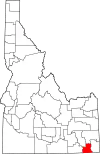
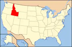
Location of Franklin County in Idaho
This is intended to be a complete list of the properties on the National Register of Historic Places in Franklin County, Idaho, United States. Latitude and longitude coordinates are provided for many National Register properties and districts; these locations may be seen together in a map.[1]
There are 10 properties listed on the National Register in the county, including 1 National Historic Landmark. More may be added; properties and districts nationwide are added to the Register weekly.[2]
- This National Park Service list is complete through NPS recent listings posted February 5, 2021.[3]
Current listings
| [4] | Name on the Register[5] | Image | Date listed[6] | Location | City or town | Description |
|---|---|---|---|---|---|---|
| 1 | Bear River Battleground | 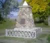 Bear River Battleground |
March 14, 1973 (#73000685) |
Northwest of Preston off U.S. Route 91 42°08′33″N 111°54′45″W |
Preston | |
| 2 | Matthias Cowley House | 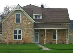 Matthias Cowley House |
July 19, 1976 (#76000673) |
110 S. 100 East 42°05′38″N 111°52′25″W |
Preston | |
| 3 | Franklin City Hall | 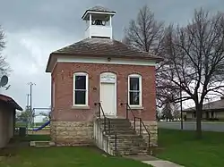 Franklin City Hall |
November 19, 1991 (#91001716) |
128 E. Main St. 42°01′02″N 111°47′57″W |
Franklin | |
| 4 | Franklin Co-operative Mercantile Institution | 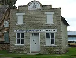 Franklin Co-operative Mercantile Institution |
November 19, 1991 (#91001717) |
113 E. Main St. 42°01′03″N 111°48′00″W |
Franklin | |
| 5 | Franklin County Courthouse | 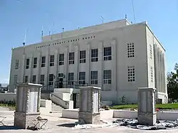 Franklin County Courthouse |
September 27, 1987 (#87001585) |
39 W. Oneida St. 42°05′45″N 111°52′38″W |
Preston | |
| 6 | L.H. Hatch House | 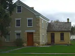 L.H. Hatch House |
May 7, 1973 (#73000684) |
125 E. Main St. 42°01′05″N 111°48′08″W |
Franklin | |
| 7 | Oneida Stake Academy | 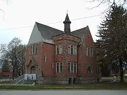 Oneida Stake Academy |
May 21, 1975 (#75000630) |
90 E. Oneida St. 42°05′46″N 111°52′28″W |
Preston | |
| 8 | Relic Hall | 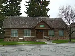 Relic Hall |
January 11, 2001 (#00001627) |
111 E. Main St. 42°01′03″N 111°48′00″W |
Franklin | |
| 9 | U.S. Post Office – Preston Main | 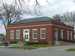 U.S. Post Office – Preston Main |
March 16, 1989 (#89000135) |
55 E. Oneida St. 42°05′47″N 111°52′28″W |
Preston | |
| 10 | Weston Canyon Rock Shelter |  Weston Canyon Rock Shelter |
July 25, 1974 (#74000738) |
Address Restricted[7] |
Weston |
See also
| Wikimedia Commons has media related to National Register of Historic Places in Franklin County, Idaho. |
References
- The latitude and longitude information provided in this table was derived originally from the National Register Information System, which has been found to be fairly accurate for about 99% of listings. Some locations in this table may have been corrected to current GPS standards.
- "National Register of Historic Places: Weekly List Actions". National Park Service. Retrieved March 29, 2009.
- "National Register of Historic Places: Weekly List Actions". National Park Service, United States Department of the Interior. Retrieved on February 5, 2021.
- Numbers represent an alphabetical ordering by significant words. Various colorings, defined here, differentiate National Historic Landmarks and historic districts from other NRHP buildings, structures, sites or objects.
- "National Register Information System". National Register of Historic Places. National Park Service. April 24, 2008.
- The eight-digit number below each date is the number assigned to each location in the National Register Information System database, which can be viewed by clicking the number.
- Some listings on the NRHP are highly sensitive sites and may be subject to looting or vandalism. The NRHP lists this site as "Address Restricted."
| Topics | |
|---|---|
| Lists by state |
|
| Lists by insular areas | |
| Lists by associated state | |
| Other areas | |
| Related | |
| |
Municipalities and communities of Franklin County, Idaho, United States | ||
|---|---|---|
| Cities | Map of Idaho highlighting Franklin County | |
| Unincorporated communities | ||
| ||
This article is issued from Wikipedia. The text is licensed under Creative Commons - Attribution - Sharealike. Additional terms may apply for the media files.