National Register of Historic Places listings in Custer County, Idaho
This is a list of the National Register of Historic Places listings in Custer County, Idaho.
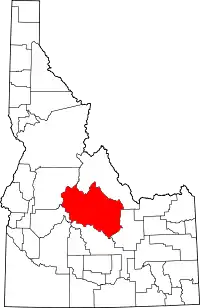
Location of Custer County in Idaho
This is intended to be a complete list of the properties and districts on the National Register of Historic Places in Custer County, Idaho, United States. Latitude and longitude coordinates are provided for many National Register properties and districts; these locations may be seen together in a map.[1]
There are 37 properties and districts listed on the National Register in the county. More may be added; properties and districts nationwide are added to the Register weekly.[2]
- This National Park Service list is complete through NPS recent listings posted January 29, 2021.[3]
Current listings
| [4] | Name on the Register[5] | Image | Date listed[6] | Location | City or town | Description |
|---|---|---|---|---|---|---|
| 1 | Bayhorse | 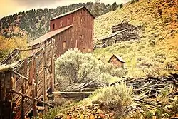 Bayhorse |
March 15, 1976 (#76000671) |
South of Challis off U.S. Route 93 44°23′52″N 114°18′42″W |
Challis | A silver mining ghost town, part of Land of the Yankee Fork State Park |
| 2 | Board-and-Batten Commercial Building | December 3, 1980 (#80001300) |
about 260 Main Ave. 44°30′19″N 114°14′09″W |
Challis | Built c.1896, removed after June 2008 | |
| 3 | Building at 247 Pleasant Avenue | December 3, 1980 (#80001301) |
247 Pleasant Ave. 44°30′13″N 114°14′10″W |
Challis | ||
| 4 | Buster Meat Market | December 3, 1980 (#80004551) |
about 250 Main Ave. 44°30′19″N 114°14′10″W |
Challis | Built in 1897, removed before June 2008 | |
| 5 | Bux's Place | December 3, 1980 (#80001302) |
321 Main Ave. 44°30′17″N 114°14′06″W |
Challis | ||
| 6 | Challis Archeological Spring District |  Challis Archeological Spring District |
February 12, 1981 (#81000206) |
Address Restricted[7] |
Challis | |
| 7 | Challis Bison Jump Site | Challis Bison Jump Site |
September 5, 1975 (#75000628) |
Address Restricted[7] |
Challis | |
| 8 | Challis Brewery Historic District | February 5, 1980 (#80001303) |
Challis Creek Rd. 44°30′28″N 114°13′38″W |
Challis | ||
| 9 | Challis Cold Storage | December 3, 1980 (#80001304) |
about 300 Main Ave. 44°30′19″N 114°14′07″W |
Challis | Built in 1881 for Idaho governor George L. Shoup, collapsed in the 1983 Borah Peak earthquake, killing two children | |
| 10 | Challis High School | December 3, 1980 (#80001305) |
701 Main Ave. 44°30′17″N 114°13′52″W |
Challis | Built in 1922, irreparably damaged by the 1983 Borah Peak earthquake, demolished | |
| 11 | Bill Chivers House | December 3, 1980 (#80001306) |
3rd St. 44°30′21″N 114°14′07″W |
Challis | ||
| 12 | Thomas Chivers Cellar | December 3, 1980 (#80001307) |
Challis Creek Rd. 44°30′27″N 114°13′34″W |
Challis | ||
| 13 | Thomas Chivers House | December 3, 1980 (#80001308) |
Challis Creek Rd. 44°30′27″N 114°13′52″W |
Challis | ||
| 14 | Custer County Jail | December 3, 1980 (#80001309) |
801 Main Ave., Rear 44°30′18″N 114°13′49″W |
Challis | ||
| 15 | Custer Historic District | 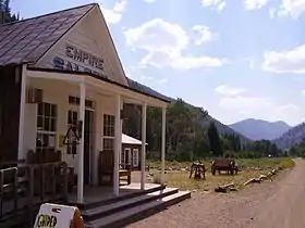 Custer Historic District |
February 3, 1981 (#81000207) |
Along Yankee Fork Road southwest of the city of Challis, within the Challis National Forest 44°23′15″N 114°41′45″W |
Custer | |
| 16 | Ivan W. Day House | April 9, 1986 (#86000754) |
Boise Meridian 44°16′06″N 114°57′05″W |
Stanley | ||
| 17 | East Fork Lookout | East Fork Lookout |
September 27, 1976 (#76000672) |
Address Restricted[7] |
Clayton | |
| 18 | False-Front Commercial Building | December 3, 1980 (#80001310) |
about 291 Main Ave. 44°30′17″N 114°14′09″W |
Challis | ||
| 19 | Emmett Hosford House | December 3, 1980 (#80001311) |
3rd St. 44°30′22″N 114°14′07″W |
Challis | ||
| 20 | I.O.O.F. Hall | December 3, 1980 (#80001312) |
521 Main Ave. 44°30′17″N 114°13′59″W |
Challis | ||
| 21 | Idaho Mining and Smelter Company Store | February 1, 2006 (#05001601) |
One Ford St. 44°15′34″N 114°23′47″W |
Clayton | ||
| 22 | Idaho Rocky Mountain Club | December 9, 1994 (#94001451) |
State Highway 75 south of Stanley 44°05′46″N 114°50′54″W |
Stanley | ||
| 23 | Mackay Episcopal Church | November 17, 1982 (#82000336) |
Park Ave. and College 43°54′40″N 113°36′47″W |
Mackay | ||
| 24 | Mackay Methodist Episcopal Church | September 7, 1984 (#84001118) |
Custer St. and Park Ave. 43°54′48″N 113°36′35″W |
Mackay | ||
| 25 | McKendrick House | December 3, 1980 (#80001313) |
4th St. 44°30′12″N 114°14′03″W |
Challis | ||
| 26 | Niece Brothers' Store | June 12, 1995 (#95000667) |
Ace of Diamonds St. 44°12′59″N 114°56′17″W |
Stanley | ||
| 27 | Old Challis Historic District | December 3, 1980 (#80001314) |
Bounded by Valley and Pleasant Aves., 2nd and 3rd Sts. 44°30′13″N 114°14′10″W |
Challis | ||
| 28 | Bill Peck House | December 3, 1980 (#80001315) |
16 Main Ave. 44°30′18″N 114°14′17″W |
Challis | ||
| 29 | Penwell House | December 3, 1980 (#80001316) |
North Ave. 44°30′23″N 114°13′50″W |
Challis | ||
| 30 | Redfish Archeological District | Redfish Archeological District |
December 29, 1983 (#83003574) |
Address Restricted[7] |
Stanley | |
| 31 | Donaldson Rowles House | December 3, 1980 (#80001317) |
North Ave. 44°30′22″N 114°13′23″W |
Challis | ||
| 32 | Henry Smith House | December 3, 1980 (#80001318) |
5th St. 44°30′13″N 114°13′59″W |
Challis | ||
| 33 | Stanley Ranger Station | 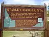 Stanley Ranger Station |
December 15, 1982 (#82001885) |
South of Stanley on U.S. Route 93 44°13′33″N 114°55′44″W |
Stanley | |
| 34 | Stone and Log Building | December 3, 1980 (#80001320) |
Pleasant Ave. 44°30′16″N 114°14′06″W |
Challis | ||
| 35 | Stone Building | December 3, 1980 (#80001319) |
3rd St. 44°30′20″N 114°14′07″W |
Challis | ||
| 36 | Twin Peaks Sports | December 3, 1980 (#80001321) |
500 Main Ave. 44°30′20″N 114°13′59″W |
Challis | ||
| 37 | Clyde Wilkinson House | December 3, 1980 (#80001322) |
9th St. 44°30′25″N 114°13′46″W |
Challis |
See also
References
- The latitude and longitude information provided in this table was derived originally from the National Register Information System, which has been found to be fairly accurate for about 99% of listings. Some locations in this table may have been corrected to current GPS standards.
- "National Register of Historic Places: Weekly List Actions". National Park Service. Retrieved March 29, 2009.
- "National Register of Historic Places: Weekly List Actions". National Park Service, United States Department of the Interior. Retrieved on January 29, 2021.
- Numbers represent an alphabetical ordering by significant words. Various colorings, defined here, differentiate National Historic Landmarks and historic districts from other NRHP buildings, structures, sites or objects.
- "National Register Information System". National Register of Historic Places. National Park Service. April 24, 2008.
- The eight-digit number below each date is the number assigned to each location in the National Register Information System database, which can be viewed by clicking the number.
- Some listings on the NRHP are highly sensitive sites and may be subject to looting or vandalism. The NRHP lists this site as "Address Restricted."
| Topics | |
|---|---|
| Lists by state |
|
| Lists by insular areas | |
| Lists by associated state | |
| Other areas | |
| Related | |
| |
Municipalities and communities of Custer County, Idaho, United States | ||
|---|---|---|
| Cities | Map of Idaho highlighting Custer County | |
| Unincorporated communities | ||
| Ghost towns | ||
| ||
This article is issued from Wikipedia. The text is licensed under Creative Commons - Attribution - Sharealike. Additional terms may apply for the media files.