National Register of Historic Places listings in Gooding County, Idaho
This is a list of the National Register of Historic Places listings in Gooding County, Idaho.
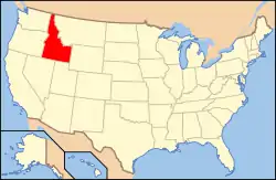
Location of Gooding County in Idaho
This is intended to be a complete list of the properties on the National Register of Historic Places in Gooding County, Idaho, United States. Latitude and longitude coordinates are provided for many National Register properties and districts; these locations may be seen together in a map.[1]
There are 13 properties listed on the National Register in the county. More may be added; properties and districts nationwide are added to the Register weekly.[2]
- This National Park Service list is complete through NPS recent listings posted February 5, 2021.[3]
Current listings
| [4] | Name on the Register[5] | Image | Date listed[6] | Location | City or town | Description |
|---|---|---|---|---|---|---|
| 1 | Citizens State Bank | 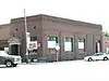 Citizens State Bank |
May 7, 1980 (#80001328) |
3rd Ave. and Main St. 42°56′34″N 114°42′44″W |
Gooding | |
| 2 | Gooding College Campus | 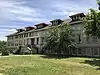 Gooding College Campus |
March 18, 1983 (#83000286) |
State Highway 26 42°55′23″N 114°42′34″W |
Gooding | |
| 3 | Hagerman State Bank, Limited |  Hagerman State Bank, Limited |
August 11, 1989 (#89001000) |
100 S. State St. 42°48′58″N 114°53′52″W |
Hagerman | |
| 4 | Kelly's Hotel | 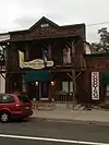 Kelly's Hotel |
September 12, 1985 (#85002155) |
112 Main 42°56′41″N 114°42′42″W |
Gooding | |
| 5 | James Henry and Ida Owen Mays House | March 9, 1993 (#92001412) |
Along the northern bank of the Snake River, 1.2 miles west of Niagara Springs 42°39′56″N 114°41′46″W |
Wendell | ||
| 6 | Owsley Bridge | 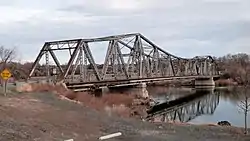 Owsley Bridge |
September 18, 1998 (#98001172) |
Approximately 200 yards north of the junction of old U.S. Route 30 and Bell Rapids Rd.[lower-alpha 1] 42°45′52″N 114°53′21″W |
Hagerman | |
| 7 | Priestly's Hydraulic Ram | February 13, 1975 (#75000631) |
6 miles south of Hagerman at Thousand Springs 42°44′40″N 114°15′25″W |
Hagerman | ||
| 8 | Morris Roberts Store | 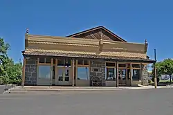 Morris Roberts Store |
July 17, 1978 (#78001062) |
Off U.S. Route 30 42°48′43″N 114°53′55″W |
Hagerman | |
| 9 | Schubert Theatre | 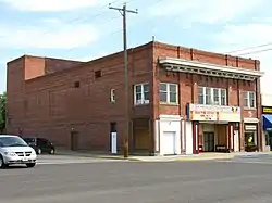 Schubert Theatre |
January 6, 2004 (#03001367) |
402 Main St. 42°56′30″N 114°42′43″W |
Gooding | |
| 10 | Archie Teater Studio | September 13, 1984 (#84001132) |
Southeast of Bliss 42°52′47″N 114°54′55″W |
Bliss | Archie Boyd Teater's artist studio, designed by Frank Lloyd Wright | |
| 11 | Thompson Mortuary Chapel | 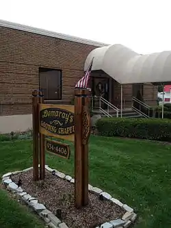 Thompson Mortuary Chapel |
November 17, 1982 (#82000348) |
737 Main St. 42°56′16″N 114°42′44″W |
Gooding | |
| 12 | Trinity Episcopal Church | 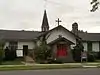 Trinity Episcopal Church |
November 17, 1982 (#82000349) |
7th and Idaho Sts. 42°56′18″N 114°42′46″W |
Gooding | |
| 13 | West Point Grade School | November 17, 1982 (#82000350) |
Off interstate 86 42°43′31″N 114°47′29″W |
Wendell |
See also
| Wikimedia Commons has media related to National Register of Historic Places in Gooding County, Idaho. |
Notes
- The Owsley Bridge spans the boundary between Gooding and Twin Falls counties.
References
- The latitude and longitude information provided in this table was derived originally from the National Register Information System, which has been found to be fairly accurate for about 99% of listings. Some locations in this table may have been corrected to current GPS standards.
- "National Register of Historic Places: Weekly List Actions". National Park Service. Retrieved March 29, 2009.
- "National Register of Historic Places: Weekly List Actions". National Park Service, United States Department of the Interior. Retrieved on February 5, 2021.
- Numbers represent an alphabetical ordering by significant words. Various colorings, defined here, differentiate National Historic Landmarks and historic districts from other NRHP buildings, structures, sites or objects.
- "National Register Information System". National Register of Historic Places. National Park Service. April 24, 2008.
- The eight-digit number below each date is the number assigned to each location in the National Register Information System database, which can be viewed by clicking the number.
| Topics | |
|---|---|
| Lists by state |
|
| Lists by insular areas | |
| Lists by associated state | |
| Other areas | |
| Related | |
| |
Municipalities and communities of Gooding County, Idaho, United States | ||
|---|---|---|
| Cities | Map of Idaho highlighting Gooding County | |
| ||
This article is issued from Wikipedia. The text is licensed under Creative Commons - Attribution - Sharealike. Additional terms may apply for the media files.