National Register of Historic Places listings in Bonner County, Idaho
This is a list of the National Register of Historic Places listings in Bonner County, Idaho.
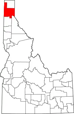
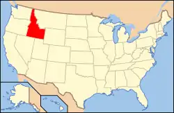
Location of Bonner County in Idaho
It is intended to be a complete list of the properties and districts on the National Register of Historic Places in Bonner County, Idaho, United States. Latitude and longitude coordinates are provided for many National Register properties and districts; these locations may be seen together in an online map.[1]
There are 16 properties and districts listed on the National Register in the county. More may be added; properties and districts nationwide are added to the Register weekly.[2]
- This National Park Service list is complete through NPS recent listings posted January 29, 2021.[3]
Current listings
| [4] | Name on the Register[5] | Image | Date listed[6] | Location | City or town | Description |
|---|---|---|---|---|---|---|
| 1 | W. A. Bernd Building | 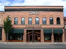 W. A. Bernd Building |
August 18, 1983 (#83000282) |
307–311 N. 1st Ave. 48°16′31″N 116°32′53″W |
Sandpoint | |
| 2 | Co-op Gas & Supply Company | 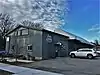 Co-op Gas & Supply Company |
January 3, 2020 (#100004821) |
524 West Church St. 48°16′26″N 116°33′19″W |
Sandpoint | |
| 3 | Dover Church | Dover Church |
August 8, 1989 (#86002153) |
Washington Ave. between 3rd and 4th Sts. 48°14′53″N 116°36′22″W |
Dover | |
| 4 | Hotel Charbonneau | 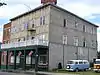 Hotel Charbonneau |
November 19, 1991 (#91001718) |
88 Wisconsin St. 48°10′45″N 116°54′32″W |
Priest River | |
| 5 | Lamb Creek School | November 30, 1999 (#99001418) |
28769 N. Highway 57 48°31′34″N 116°56′20″W |
Priest River | ||
| 6 | Amanda Nesbitt House | 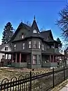 Amanda Nesbitt House |
July 15, 1982 (#82002508) |
602 N. 4th Ave. 48°16′42″N 116°33′05″W |
Sandpoint | |
| 7 | Charles A. and Mary Olson House | 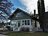 Charles A. and Mary Olson House |
May 30, 2001 (#01000566) |
401 Church St. 48°16′26″N 116°33′08″W |
Sandpoint | |
| 8 | Priest River Commercial Core Historic District | 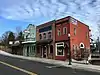 Priest River Commercial Core Historic District |
August 31, 1995 (#95001057) |
Roughly bounded by Wisconsin, Montgomery, and Cedar Sts. and Albeni Rd. 48°10′45″N 116°54′27″W |
Priest River | |
| 9 | Priest River Experimental Forest | July 1, 1994 (#94000661) |
Idaho Panhandle National Forest 48°21′09″N 116°47′49″W |
Sandpoint | ||
| 10 | Priest River High School | 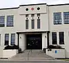 Priest River High School |
December 7, 1995 (#95001402) |
1020 W. Albeni Rd. 48°10′52″N 116°55′07″W |
Priest River | Building is used by Priest River Junior High |
| 11 | Sandpoint Burlington Northern Railway Station |  Sandpoint Burlington Northern Railway Station |
July 5, 1973 (#73000682) |
Cedar St. at Sand Creek 48°16′35″N 116°32′44″W |
Sandpoint | |
| 12 | Sandpoint Community Hall | 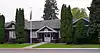 Sandpoint Community Hall |
September 11, 1986 (#86002148) |
204 S. 1st Ave. 48°16′18″N 116°32′53″W |
Sandpoint | |
| 13 | Sandpoint Federal Building | 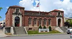 Sandpoint Federal Building |
August 8, 2001 (#01000836) |
419 N. 2nd Ave. 48°16′37″N 116°32′57″W |
Sandpoint | |
| 14 | Sandpoint High School | 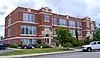 Sandpoint High School |
October 28, 1999 (#99001277) |
102 S. Euclid Ave. 48°16′21″N 116°33′17″W |
Sandpoint | Currently the Sandpoint Events Center |
| 15 | Sandpoint Historic District | 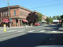 Sandpoint Historic District |
September 7, 1984 (#84001100) |
Roughly bounded by Pine & Cedar Sts., 1st, 2nd & 3rd Aves. 48°16′32″N 116°32′54″W |
Sandpoint | Boundary increase accepted June 21, 2018. |
| 16 | Settlement School | 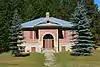 Settlement School |
April 1, 1999 (#99000418) |
Settlement Rd., 0.5 miles east of its junction with E. Side Rd. 48°10′55″N 116°52′28″W |
Priest River | |
| 17 | Vinther and Nelson Cabin | July 21, 1982 (#82002507) |
Eightmile Island 48°34′47″N 116°50′19″W |
Coolin |
See also
| Wikimedia Commons has media related to National Register of Historic Places in Bonner County, Idaho. |
References
- The latitude and longitude information provided in this table was derived originally from the National Register Information System, which has been found to be fairly accurate for about 99% of listings. Some locations in this table may have been corrected to current GPS standards.
- "National Register of Historic Places: Weekly List Actions". National Park Service. Retrieved March 29, 2009.
- "National Register of Historic Places: Weekly List Actions". National Park Service, United States Department of the Interior. Retrieved on January 29, 2021.
- Numbers represent an alphabetical ordering by significant words. Various colorings, defined here, differentiate National Historic Landmarks and historic districts from other NRHP buildings, structures, sites or objects.
- "National Register Information System". National Register of Historic Places. National Park Service. April 24, 2008.
- The eight-digit number below each date is the number assigned to each location in the National Register Information System database, which can be viewed by clicking the number.
| Topics | |
|---|---|
| Lists by state |
|
| Lists by insular areas | |
| Lists by associated state | |
| Other areas | |
| Related | |
| |
Municipalities and communities of Bonner County, Idaho, United States | ||
|---|---|---|
| Cities | Map of Idaho highlighting Bonner County | |
| CDP | ||
| Unincorporated communities | ||
| ||
This article is issued from Wikipedia. The text is licensed under Creative Commons - Attribution - Sharealike. Additional terms may apply for the media files.