National Register of Historic Places listings in Bannock County, Idaho
This is a list of the National Register of Historic Places listings in Bannock County, Idaho.
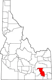
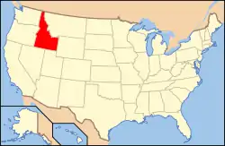
Location of Bannock County in Idaho
This is intended to be a complete list of the properties and districts on the National Register of Historic Places in Bannock County, Idaho, United States. Latitude and longitude coordinates are provided for many National Register properties and districts; these locations may be seen together in a map.[1]
There are 29 properties and districts listed on the National Register in the county, including 1 National Historic Landmark. More may be added; properties and districts nationwide are added to the Register weekly.[2]
- This National Park Service list is complete through NPS recent listings posted January 29, 2021.[3]
Current listings
| [4] | Name on the Register[5] | Image | Date listed[6] | Location | City or town | Description |
|---|---|---|---|---|---|---|
| 1 | A.F.R. Building | 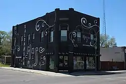 A.F.R. Building |
November 15, 1990 (#90001737) |
501 N. Main St. 42°51′55″N 112°27′13″W |
Pocatello | |
| 2 | Brady Memorial Chapel | 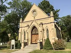 Brady Memorial Chapel |
May 1, 1979 (#79000772) |
Mountain View Cemetery, 1520 S. 5th Ave. 42°51′20″N 112°25′44″W |
Pocatello | |
| 3 | Church of the Assumption | 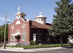 Church of the Assumption |
May 1, 1979 (#79000773) |
528 N. 5th Ave. 42°52′12″N 112°26′46″W |
Pocatello | |
| 4 | East Side Downtown Historic District | November 25, 1994 (#94001361) |
Roughly including the 200 and 300 blocks of E. Center St., the 100 block of N. 2nd Ave., and the 100 block of S. 2nd Ave. 42°51′43″N 112°26′46″W |
Pocatello | ||
| 5 | Fort Hall | 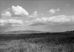 Fort Hall |
October 15, 1966 (#66000306) |
11 miles west of Fort Hall on the Fort Hall Indian Reservation 43°01′24″N 112°37′58″W |
Fort Hall | Site of the first Fort Hall, 1834-1856 |
| 6 | H.O. Harkness Stable Building | 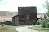 H.O. Harkness Stable Building |
February 1, 1980 (#80001293) |
105 S. Railroad Ave. 42°39′21″N 112°11′33″W |
McCammon | |
| 7 | John Hood House | 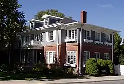 John Hood House |
December 14, 1978 (#78001043) |
554 S. 7th Ave. 42°51′58″N 112°26′17″W |
Pocatello | |
| 8 | William A. Hyde House |  William A. Hyde House |
June 23, 1983 (#83000259) |
429 N. 7th St. 42°52′10″N 112°26′39″W |
Pocatello | |
| 9 | Idaho State University Administration Building | 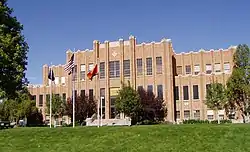 Idaho State University Administration Building |
September 23, 1993 (#93000994) |
919 S. 8th St., Building 10, on the Idaho State University campus 42°51′43″N 112°25′58″W |
Pocatello | |
| 10 | Idaho State University Neighborhood Historic District | September 7, 1984 (#84001008) |
Roughly bounded by 6th, 9th, Carter, and Center Sts. 42°51′57″N 112°26′15″W |
Pocatello | ||
| 11 | L.D.S. Ward Building | December 9, 1999 (#99001474) |
187 S. 2nd Ave. 42°37′04″N 112°00′51″W |
Lava Hot Springs | ||
| 12 | Lava High School Gymnasium | July 9, 1997 (#97000764) |
202 W. Fife St. 42°37′00″N 112°00′52″W |
Lava Hot Springs | ||
| 13 | Lincoln-Johnson Avenues Residential Historic District | March 15, 2006 (#06000126) |
Roughly bounded by W. Hayden St., the Portneuf River, W. Benton St., and the West Bench 42°51′30″N 112°27′17″W |
Pocatello | ||
| 14 | McCammon State Bank Building | 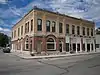 McCammon State Bank Building |
July 9, 1979 (#79000771) |
206 Center St. 42°39′14″N 112°11′40″W |
McCammon | Built in 1906, now the Harkness Hotel |
| 15 | Old Town Residential Historic District | April 2, 2008 (#08000249) |
Roughly bounded by W. Benton, S. Garfield, and W. Lewis Sts., and the Portneuf River 42°51′30″N 112°27′06″W |
Pocatello | ||
| 16 | Pocatello Carnegie Library | 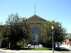 Pocatello Carnegie Library |
July 2, 1973 (#73000679) |
113 S. Garfield Ave. 42°51′38″N 112°27′08″W |
Pocatello | |
| 17 | Pocatello Federal Building | 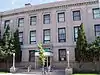 Pocatello Federal Building |
October 5, 1977 (#77000452) |
150 S. Arthur Ave. 42°51′40″N 112°27′00″W |
Pocatello | |
| 18 | Pocatello Historic District | 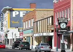 Pocatello Historic District |
June 3, 1982 (#82002505) |
Roughly bounded by railroad tracks and W. Fremont, W. Bonneville, and Garfield Sts. 42°51′44″N 112°27′03″W |
Pocatello | |
| 19 | Pocatello Warehouse Historic District | September 3, 1996 (#96000946) |
Roughly bounded by S. 2nd Ave., E. Halliday, E. Sutter, and the Oregon Short Line railroad tracks 42°51′29″N 112°26′20″W |
Pocatello | ||
| 20 | Pocatello Westside Residential Historic District | March 17, 2003 (#03000102) |
Roughly bounded by N. Arthur Ave., W. Fremont St., N. Grant Ave., and W. Young St. 42°51′53″N 112°27′26″W |
Pocatello | ||
| 21 | Quinn Apartments | 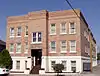 Quinn Apartments |
January 11, 1985 (#85000057) |
580 W. Clark St. 42°51′41″N 112°27′12″W |
Pocatello | |
| 22 | Rice-Packard House | 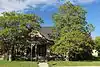 Rice-Packard House |
September 12, 1985 (#85002159) |
454 N. Hayes Ave. 42°51′48″N 112°27′21″W |
Pocatello | |
| 23 | Riverside Inn | August 29, 1979 (#79000770) |
255 E. Portneuf St. 42°37′11″N 112°00′33″W |
Lava Hot Springs | ||
| 24 | St. Joseph's Catholic Church | 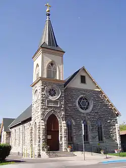 St. Joseph's Catholic Church |
August 29, 1978 (#78001044) |
455 N. Hayes 42°51′46″N 112°27′23″W |
Pocatello | |
| 25 | Standrod House | 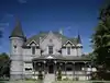 Standrod House |
January 18, 1973 (#73000680) |
648 N. Garfield Ave. 42°51′54″N 112°27′27″W |
Pocatello | |
| 26 | Sullivan-Kinney House | 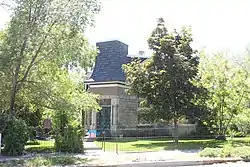 Sullivan-Kinney House |
November 9, 1977 (#77000453) |
441 S. Garfield Ave. 42°51′29″N 112°26′55″W |
Pocatello | |
| 27 | Trinity Episcopal Church | 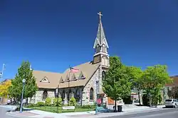 Trinity Episcopal Church |
February 17, 1978 (#78001045) |
248 N. Arthur St. 42°51′47″N 112°27′08″W |
Pocatello | |
| 28 | Whitestone Hotel | April 7, 1980 (#80001292) |
2nd Ave. and Main St. 42°37′11″N 112°00′31″W |
Lava Hot Springs | Demolished in 1997 | |
| 29 | Woolley Apartments | 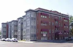 Woolley Apartments |
October 31, 1985 (#85003425) |
303 N. Hayes Ave. 42°51′42″N 112°27′18″W |
Pocatello |
See also
| Wikimedia Commons has media related to National Register of Historic Places in Bannock County, Idaho. |
References
- The latitude and longitude information provided in this table was derived originally from the National Register Information System, which has been found to be fairly accurate for about 99% of listings. Some locations in this table may have been corrected to current GPS standards.
- "National Register of Historic Places: Weekly List Actions". National Park Service. Retrieved March 29, 2009.
- "National Register of Historic Places: Weekly List Actions". National Park Service, United States Department of the Interior. Retrieved on January 29, 2021.
- Numbers represent an alphabetical ordering by significant words. Various colorings, defined here, differentiate National Historic Landmarks and historic districts from other NRHP buildings, structures, sites or objects.
- "National Register Information System". National Register of Historic Places. National Park Service. April 24, 2008.
- The eight-digit number below each date is the number assigned to each location in the National Register Information System database, which can be viewed by clicking the number.
| Topics | |
|---|---|
| Lists by state |
|
| Lists by insular areas | |
| Lists by associated state | |
| Other areas | |
| Related | |
| |
Municipalities and communities of Bannock County, Idaho, United States | ||
|---|---|---|
| Cities | Map of Idaho highlighting Bannock County | |
| CDPs | ||
| Unincorporated communities | ||
| Indian reservation | ||
| Ghost town | ||
| Footnotes | ‡This populated place also has portions in an adjacent county or counties | |
| ||
This article is issued from Wikipedia. The text is licensed under Creative Commons - Attribution - Sharealike. Additional terms may apply for the media files.