National Register of Historic Places listings in Canyon County, Idaho
This is a list of the National Register of Historic Places listings in Canyon County, Idaho.
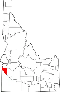
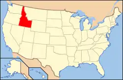
Location of Canyon County in Idaho
This is intended to be a complete list of the properties and districts on the National Register of Historic Places in Canyon County, Idaho, United States. Latitude and longitude coordinates are provided for many National Register properties and districts; these locations may be seen together in a Google map.[1]
There are 47 properties and districts listed on the National Register in the county. More may be added; properties and districts nationwide are added to the Register weekly.[2]
- This National Park Service list is complete through NPS recent listings posted January 29, 2021.[3]
Current listings
| [4] | Name on the Register[5] | Image | Date listed[6] | Location | City or town | Description |
|---|---|---|---|---|---|---|
| 1 | F. F. Beale House | .jpg.webp) F. F. Beale House |
May 14, 1993 (#93000386) |
1802 Cleveland Boulevard 43°39′25″N 116°40′46″W |
Caldwell | |
| 2 | Blatchley Hall |  Blatchley Hall |
March 8, 1978 (#78001055) |
College of Idaho campus 43°39′09″N 116°40′31″W |
Caldwell | |
| 3 | Boise River and Canal Bridge | _(5).jpg.webp) Boise River and Canal Bridge |
February 7, 2007 (#07000003) |
Plymouth St. 43°41′20″N 116°41′13″W |
Caldwell | |
| 4 | Caldwell Carnegie Library | .jpg.webp) Caldwell Carnegie Library |
June 18, 1979 (#79000784) |
1101 Cleveland Boulevard 43°39′44″N 116°41′10″W |
Caldwell | |
| 5 | Caldwell Historic District | .jpg.webp) Caldwell Historic District |
July 19, 1982 (#82002509) |
Roughly bounded by Railroad and Arthur Sts. and 7th and 9th Aves. 43°39′59″N 116°41′16″W |
Caldwell | |
| 6 | Caldwell Odd Fellow Home for the Aged | .jpg.webp) Caldwell Odd Fellow Home for the Aged |
November 17, 1982 (#82000322) |
N. 14th Ave. 43°39′59″N 116°40′24″W |
Caldwell | |
| 7 | Caldwell Residential Historic District |  Caldwell Residential Historic District |
September 23, 2002 (#02001064) |
Roughly bounded by Cleveland Boulevard, Everett St., S. 12th Ave., and S. 20th Ave. 43°39′28″N 116°40′56″W |
Caldwell | |
| 8 | E. H. Dewey Stores | .jpg.webp) E. H. Dewey Stores |
November 17, 1982 (#82000323) |
1013-1015 1st St., S. 43°34′47″N 116°33′41″W |
Nampa | |
| 9 | Diversion Dam and Deer Flat Embankments | 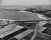 Diversion Dam and Deer Flat Embankments |
March 15, 1976 (#76000666) |
Southeast of Boise on the Boise River 43°34′26″N 116°42′23″W |
Boise | Extends into Ada County |
| 10 | Henry W. and Ida Frost Dorman House | 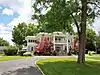 Henry W. and Ida Frost Dorman House |
July 5, 2000 (#00000756) |
114 E. Logan St. 43°39′17″N 116°41′50″W |
Caldwell | |
| 11 | Farmers and Merchants Bank | .jpg.webp) Farmers and Merchants Bank |
May 13, 1976 (#76000670) |
101 11th Ave., S. 43°34′46″N 116°33′40″W |
Nampa | |
| 12 | Fort Boise and Riverside Ferry Sites | 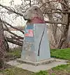 Fort Boise and Riverside Ferry Sites |
December 24, 1974 (#74000736) |
Northwest of Parma on the Snake River 43°49′25″N 117°01′13″W |
Parma | |
| 13 | Guffey Butte – Black Butte Archeological District | 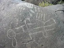 Guffey Butte – Black Butte Archeological District |
October 10, 1978 (#78001038) |
Along approximately 34 miles (55 km) of the Snake River in Canyon, Ada, Owyhee, and Elmore counties[7] 43°17′57″N 116°31′18″W |
Grand View | |
| 14 | Horse Barn | October 11, 1978 (#78001057) |
Northeast of Nampa at Idaho State School and Hospital 43°36′12″N 116°31′32″W |
Nampa | ||
| 15 | Ellen Houlder Farm | June 23, 1994 (#94000631) |
Arena Valley Rd. (Route 2) west of Wilder 43°40′49″N 116°59′28″W |
Wilder | ||
| 16 | Idaho State Sanitarium Administration Building | 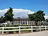 Idaho State Sanitarium Administration Building |
November 17, 1982 (#82000324) |
Northeast of Nampa on 11th Ave., N. 43°36′09″N 116°31′53″W |
Nampa | |
| 17 | Thomas K. Little House | 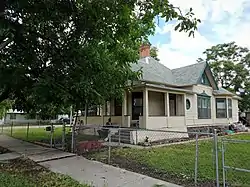 Thomas K. Little House |
August 18, 1980 (#80001295) |
703 E. Belmont St. 43°40′08″N 116°41′08″W |
Caldwell | |
| 18 | Jacob P. Lockman House | .jpg.webp) Jacob P. Lockman House |
July 27, 2005 (#05000735) |
23 9th Ave. N 43°34′58″N 116°33′40″W |
Nampa | |
| 19 | MacMillan Chapel |  MacMillan Chapel |
September 7, 1984 (#84000989) |
18121 Dean Ln 43°38′10″N 116°31′19″W |
Nampa | MacMillan Chapel was moved in 2004 from Ada County to Canyon County, and it is included on the Ada County page under former listings. |
| 20 | Map Rock Petroglyphs Historic District | 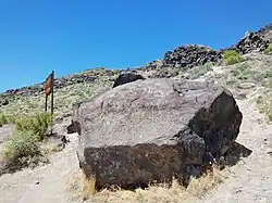 Map Rock Petroglyphs Historic District |
November 15, 1982 (#82000325) |
Map Rock Rd.[8] 43°25′16″N 116°42′17″W |
Givens Hot Springs | |
| 21 | Mercy Hospital | August 19, 2014 (#14000504) |
1615 8th St., S. 43°34′12″N 116°33′45″W |
Nampa | Demolished in 2016[9] | |
| 22 | Middleton Substation | 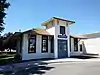 Middleton Substation |
May 7, 1973 (#73000683) |
State Highway 44 43°42′23″N 116°37′07″W |
Middleton | |
| 23 | Nampa American Legion Chateau | .jpg.webp) Nampa American Legion Chateau |
November 17, 1982 (#82000326) |
1508 2nd St., S. 43°34′33″N 116°33′26″W |
Nampa | |
| 24 | Nampa and Meridian Irrigation District Office | .jpg.webp) Nampa and Meridian Irrigation District Office |
November 17, 1982 (#82000329) |
1503 1st St., S. 43°34′35″N 116°33′24″W |
Nampa | |
| 25 | Nampa City Hall | 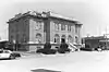 Nampa City Hall |
May 9, 1985 (#85000967) |
203 12th Ave., S. 43°34′41″N 116°33′41″W |
Nampa | Demolished in 1991 |
| 26 | Nampa Department Store | .jpg.webp) Nampa Department Store |
November 17, 1982 (#82000327) |
1st St., S. and 13th Ave. 43°34′40″N 116°33′31″W |
Nampa | |
| 27 | Nampa Depot | .jpg.webp) Nampa Depot |
November 3, 1972 (#72000438) |
12th Ave. and Front St. 43°34′47″N 116°33′31″W |
Nampa | |
| 28 | Nampa First Methodist Episcopal Church | .jpg.webp) Nampa First Methodist Episcopal Church |
November 17, 1982 (#82000328) |
12th Ave., S. and 4th St. 43°34′34″N 116°33′46″W |
Nampa | |
| 29 | Nampa Historic District | 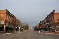 Nampa Historic District |
August 18, 1983 (#83000284) |
1200 and 1300 blocks S. 1st St. 43°34′41″N 116°33′31″W |
Nampa | |
| 30 | Nampa Presbyterian Church | 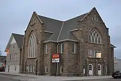 Nampa Presbyterian Church |
November 17, 1982 (#82000330) |
2nd St. and 15th Ave., S. 43°34′33″N 116°33′29″W |
Nampa | |
| 31 | Nampa Valley Grange No.131 | 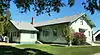 Nampa Valley Grange No.131 |
February 13, 2013 (#13000002) |
203 5th Ave., S. 43°34′59″N 116°34′07″W |
Nampa | |
| 32 | North Caldwell Historic District | .jpg.webp) North Caldwell Historic District |
September 5, 1979 (#79000785) |
9th, Albany, and Belmont Sts. 43°40′01″N 116°41′03″W |
Caldwell | |
| 33 | George Obendorf Gothic Arch Truss Barn | 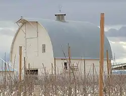 George Obendorf Gothic Arch Truss Barn |
October 28, 1999 (#99001278) |
24047 Batt Corner Rd. 43°43′14″N 116°55′23″W |
Wilder | |
| 34 | Old Nampa Neighborhood Historic District | .jpg.webp) Old Nampa Neighborhood Historic District |
March 21, 2007 (#07000164) |
Roughly bounded by 4th Ave., S, 4th St., S, 11th Ave., S, and 9th St., S. 43°34′41″N 116°34′10″W |
Nampa | |
| 35 | Peckham Barn | 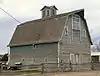 Peckham Barn |
October 7, 1982 (#82000389) |
North of Wilder on U.S. Route 95 43°41′01″N 116°54′37″W |
Wilder | |
| 36 | John C. Rice House | 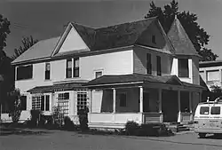 John C. Rice House |
May 27, 1980 (#80001296) |
1520 Cleveland Boulevard 43°39′31″N 116°40′55″W |
Caldwell | Building has apparently been moved.
New location: 43.651062, -116.680252 |
| 37 | Roswell Grade School | .jpg.webp) Roswell Grade School |
November 17, 1982 (#82000331) |
State Highway 18 and Stephan Lane 43°44′55″N 116°57′41″W |
Roswell | |
| 38 | Sacred Hearts of Jesus and Mary Church | 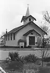 Sacred Hearts of Jesus and Mary Church |
November 17, 1982 (#82000334) |
608 7th St. 43°47′15″N 116°56′17″W |
Parma | Building no longer exists. |
| 39 | St. Mary's Catholic Church | 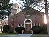 St. Mary's Catholic Church |
November 17, 1982 (#82000332) |
616 Dearborn St. 43°39′51″N 116°41′32″W |
Caldwell | |
| 40 | St. Paul's Rectory and Sisters' House | 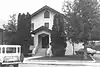 St. Paul's Rectory and Sisters' House |
November 17, 1982 (#82000333) |
810 15th Ave., S. 43°34′15″N 116°33′49″W |
Nampa | Building no longer exists. |
| 41 | Sterry Hall | 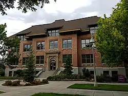 Sterry Hall |
March 8, 1978 (#78001056) |
College of Idaho campus 43°39′14″N 116°40′36″W |
Caldwell | |
| 42 | A. K. Steunenberg House | _(1).jpg.webp) A. K. Steunenberg House |
November 17, 1982 (#82000335) |
409 N. Kimball Ave. 43°40′09″N 116°41′02″W |
Caldwell | |
| 43 | A. H. Stewart House | 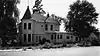 A. H. Stewart House |
October 25, 1979 (#79000786) |
3rd St. and Bates Ave 43°47′10″N 116°56′37″W |
Parma | Building no longer exists. |
| 44 | Carrie Adell Strahorn Memorial Library | 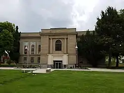 Carrie Adell Strahorn Memorial Library |
April 15, 1982 (#82002510) |
College of Idaho campus 43°39′10″N 116°40′36″W |
Caldwell | |
| 45 | U.S. Post Office – Caldwell Main | 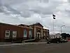 U.S. Post Office – Caldwell Main |
March 16, 1989 (#89000131) |
823 Arthur St. 43°39′55″N 116°41′14″W |
Caldwell | |
| 46 | U.S. Post Office – Nampa Main | .jpg.webp) U.S. Post Office – Nampa Main |
March 16, 1989 (#89000132) |
123 11th Ave., S. 43°34′45″N 116°33′42″W |
Nampa | |
| 47 | H. Orton Wiley House | .jpg.webp) H. Orton Wiley House |
September 11, 1986 (#86002163) |
524 E. Dewey Ave. 43°33′49″N 116°33′58″W |
Nampa | Built in 1922-23, significant for association with H. Orton Wiley and Northwest Nazarene College. |
Former listings
| [4] | Name on the Register | Image | Date listed | Date removed | Location | City or town | Summary |
|---|---|---|---|---|---|---|---|
| 1 | Academy Building, College of Idaho | October 11, 1978 (#78001054) | January 31, 1986 | 1015 Albany St. |
Caldwell |
See also
| Wikimedia Commons has media related to National Register of Historic Places in Canyon County, Idaho. |
References
- The latitude and longitude information provided in this table was derived originally from the National Register Information System, which has been found to be fairly accurate for about 99% of listings. Some locations in this table may have been corrected to current GPS standards.
- "National Register of Historic Places: Weekly List Actions". National Park Service. Retrieved March 29, 2009.
- "National Register of Historic Places: Weekly List Actions". National Park Service, United States Department of the Interior. Retrieved on January 29, 2021.
- Numbers represent an alphabetical ordering by significant words. Various colorings, defined here, differentiate National Historic Landmarks and historic districts from other NRHP buildings, structures, sites or objects.
- "National Register Information System". National Register of Historic Places. National Park Service. April 24, 2008.
- The eight-digit number below each date is the number assigned to each location in the National Register Information System database, which can be viewed by clicking the number.
- Map #8 - Guffey Butte / Black Butte Historical District (PDF) (Map). Bureau of Land Management. January 28, 2011. Retrieved March 14, 2015. Coordinates mark Celebration Park, which protects a set of archeological resources that are part of the historic district.
- Canyon County Parks, Recreation and Waterways, Map Rock, archived from the original on March 21, 2015, retrieved March 14, 2015.
| Topics | |
|---|---|
| Lists by state |
|
| Lists by insular areas | |
| Lists by associated state | |
| Other areas | |
| Related | |
| |
Municipalities and communities of Canyon County, Idaho, United States | ||
|---|---|---|
| Cities | Map of Idaho highlighting Canyon County | |
| Unincorporated communities | ||
| ||
This article is issued from Wikipedia. The text is licensed under Creative Commons - Attribution - Sharealike. Additional terms may apply for the media files.