National Register of Historic Places listings in Piscataquis County, Maine
This is a list of the National Register of Historic Places listings in Piscataquis County, Maine.
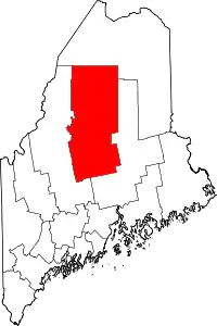
Location of Piscataquis County in Maine
This is intended to be a complete list of the properties and districts on the National Register of Historic Places in Piscataquis County, Maine, United States. Latitude and longitude coordinates are provided for many National Register properties and districts; these locations may be seen together in a map.[1]
There are 56 properties and districts listed on the National Register in the county. Another 3 properties were once listed, but have since been removed.
- This National Park Service list is complete through NPS recent listings posted February 5, 2021.[2]
| Androscoggin - Aroostook - Cumberland - Franklin - Hancock - Kennebec - Knox - Lincoln - Oxford - Penobscot - Piscataquis - Sagadahoc - Somerset - Waldo - Washington - York |
Current listings
| [3] | Name on the Register[4] | Image | Date listed[5] | Location | City or town | Description |
|---|---|---|---|---|---|---|
| 1 | Ambajejus Boom House | 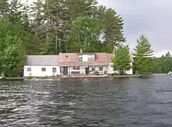 Ambajejus Boom House |
April 2, 1973 (#73000145) |
About 11 miles (18 km) northwest of Millinocket and Ambajejus Lake 45°43′57″N 68°53′42″W |
Northeast Piscataquis | |
| 2 | American Woolen Company Foxcroft Mill |  American Woolen Company Foxcroft Mill |
December 19, 2012 (#12001068) |
E. Main St. 45°11′00″N 69°13′50″W |
Dover-Foxcroft | |
| 3 | Archeological Site No. 121-52a | October 31, 1995 (#95001212) |
Address Restricted |
Ambajejus Camps | ||
| 4 | Archeological Site No. 121-52B | October 31, 1995 (#95001213) |
Address Restricted |
Ambajejus Camps | ||
| 5 | Archeological Site No. 121-59 | October 31, 1995 (#95001214) |
Address Restricted |
Stephensons Landing | ||
| 6 | Archeological Site No. 121-71 | October 31, 1995 (#95001215) |
Address Restricted |
Amgajejus Camps | ||
| 7 | Archeological Site No. 122-4a | October 31, 1995 (#95001202) |
Address Restricted |
Northeast Piscataquis | ||
| 8 | Archeological Site No. 133.7 | April 25, 1986 (#86000858) |
Address Restricted |
Chesuncook | ||
| 9 | Archeological Site No. 133.8 | April 25, 1986 (#86000861) |
Address Restricted |
Chesuncook | ||
| 10 | Archeological Site No. 142-12 | October 31, 1995 (#95001221) |
Address Restricted |
Ripogenus | ||
| 11 | Archeological Site No. 142-13 | October 31, 1995 (#95001222) |
Address Restricted |
Ripogenus | ||
| 12 | Archeological Site No. 142-14 | October 31, 1995 (#95001223) |
Address Restricted |
Ripogenus | ||
| 13 | Archeological Site No. 142-5 | October 31, 1995 (#95001218) |
Address Restricted |
Ripogenus | ||
| 14 | Archeological Site No. 142-6 | October 31, 1995 (#95001219) |
Address Restricted |
Ripogenus | ||
| 15 | Archeological Site No. 142-8 | October 31, 1995 (#95001220) |
Address Restricted |
Ripogenus | ||
| 16 | Archeological Site No. 143-12 | October 31, 1995 (#95001209) |
Address Restricted |
Ripogenus | ||
| 17 | Archeological Site No. 143-15 | October 31, 1995 (#95001210) |
Address Restricted |
Ripogenus | ||
| 18 | Archeological Site No. 143-16 | October 31, 1995 (#95001211) |
Address Restricted |
Ripogenus | ||
| 19 | Archeological Site No. 143-23 | October 31, 1995 (#95001203) |
Address Restricted |
Chesuncook | ||
| 20 | Archeological Site No. 143-5 | October 31, 1995 (#95001208) |
Address Restricted |
Ripogenus | ||
| 21 | Archeological Site No. 143-52 | October 31, 1995 (#95001205) |
Address Restricted |
Chesuncook | ||
| 22 | Archeological Site No. 143-53 | October 31, 1995 (#95001206) |
Address Restricted |
Chesuncook | ||
| 23 | Archeological Site No. 143-57 | October 31, 1995 (#95001207) |
Address Restricted |
Chesuncook | ||
| 24 | Archeological Site No. 143-79 | October 31, 1995 (#95001204) |
Address Restricted |
Chesuncook | ||
| 25 | Boarding House and Storehouse at Churchill Depot | December 31, 2018 (#100003258) |
S of Churchill Dam Rd. 500 ft NE of Chamberlain Dam 46°29′41″N 69°17′11″W |
Churchill Depot | ||
| 26 | The Breakwater | April 11, 2002 (#02000349) |
Southern tip of Kineo Island on the western side of Kineo Cove 45°41′16″N 69°43′43″W |
Rockwood | ||
| 27 | Brockway Site (ME 90.3) | July 27, 1987 (#87001152) |
Address Restricted |
Milo | ||
| 28 | Brown House | February 14, 1985 (#85000273) |
High St. 45°18′20″N 69°02′30″W |
Brownville | ||
| 29 | Burgess House | May 3, 1978 (#78000196) |
Burgess Road, east of Austin Road 45°16′10″N 69°06′53″W |
Sebec | ||
| 30 | Canadian Pacific Railway Depot, Greenville Junction, Maine | 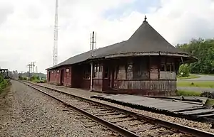 Canadian Pacific Railway Depot, Greenville Junction, Maine |
March 27, 2017 (#100000809) |
0.2 miles north of the junction of Rockwood Road and Pritham Avenue 45°27′48″N 69°37′22″W |
Greenville Junction | |
| 31 | Robert Carleton House | December 6, 1975 (#75000108) |
N. Main St. 45°09′56″N 69°21′26″W |
Sangerville | ||
| 32 | Chandler-Parsons Blacksmith Shop | October 16, 1989 (#89001702) |
Dawes Rd. 45°12′13″N 69°15′27″W |
Dover-Foxcroft | ||
| 33 | Chesuncook Village |  Chesuncook Village |
April 11, 1973 (#73000262) |
Northwestern shore of Chesuncook Lake 46°04′N 69°25′W |
Chesuncook | |
| 34 | Free Will Baptist Church (Former) | 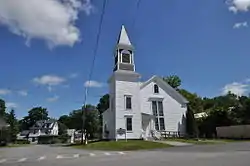 Free Will Baptist Church (Former) |
October 12, 2000 (#00001205) |
Junction of High St. and Highland Ave. 45°15′11″N 68°59′04″W |
Milo | Now the local historical society museum |
| 35 | Guilford Memorial Library | 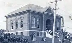 Guilford Memorial Library |
July 31, 1986 (#86002107) |
Library and Water Sts. 45°10′11″N 69°23′01″W |
Guilford | |
| 36 | Harriman School | June 24, 1996 (#96000653) |
Northern side of North Rd., 1.7 miles (2.7 km) northeast of its junction with Parson Landing Rd. 45°14′05″N 69°08′49″W |
Sebec | Listed in Dover-Foxcroft vicinity | |
| 37 | Hathaway Barn | April 22, 2003 (#03000288) |
135 Nortons Corner Rd. 45°17′37″N 69°25′24″W |
Willimantic | ||
| 38 | H. Hudson Law Office | October 9, 1979 (#79000162) |
Hudson Ave. 45°10′01″N 69°23′06″W |
Guilford | ||
| 39 | KATAHDIN (Lake Boat) |  KATAHDIN (Lake Boat) |
September 13, 1978 (#78003435) |
Moosehead Lake 45°28′09″N 69°37′17″W |
Greenville | |
| 40 | Katahdin Ironworks | Katahdin Ironworks |
December 23, 1969 (#69000011) |
Northwest of Brownville Junction at Silver Lake 45°26′44″N 69°10′26″W |
Brownville Junction | |
| 41 | Kineo Cottage Row Historic District | 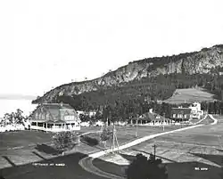 Kineo Cottage Row Historic District |
January 14, 2004 (#03001408) |
Western side of the Kineo Peninsula in Moosehead Lake 45°41′25″N 69°44′02″W |
Kineo Township | |
| 42 | Little Schoodic Stream Archeological Site (107-4) | April 20, 1989 (#89000256) |
Address Restricted |
Medford | ||
| 43 | Milo Public Library | 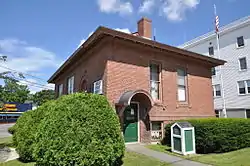 Milo Public Library |
January 5, 1989 (#88003017) |
4 Pleasant St. 45°15′45″N 68°59′12″W |
Milo | |
| 44 | Monson Community Church | 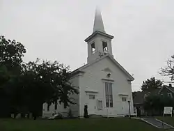 Monson Community Church |
July 30, 2012 (#12000453) |
19 Greenville Rd. 45°17′12″N 69°30′04″W |
Monson | |
| 45 | Monson Engine House (Former) | 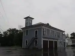 Monson Engine House (Former) |
August 5, 2005 (#05000798) |
6 Tenney Hill Rd. 45°17′10″N 69°30′00″W |
Monson | Now a local historical society museum. |
| 46 | Munsungan-Chase Lake Thoroughfare Archeological District | September 6, 1979 (#79000163) |
Address Restricted |
Millinocket Lake | ||
| 47 | Norton's Corner School | July 14, 2015 (#15000418) |
2373 Elliotsville Rd. 45°18′18″N 69°24′35″W |
Willimantic | Now houses the Willimantic Library | |
| 48 | Observer Building | 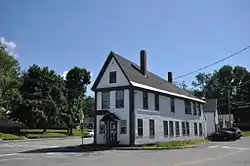 Observer Building |
June 26, 1998 (#98000724) |
128 Union Sq. 45°11′00″N 69°13′38″W |
Dover-Foxcroft | Now a historical society museum. |
| 49 | Sangerville Town Hall | March 22, 1991 (#91000322) |
Main St. 45°09′56″N 69°21′30″W |
Sangerville | ||
| 50 | Sebec-Piscataquis River Confluence Prehistoric Archeological District | December 24, 1986 (#86003482) |
Address Restricted 45°13′59″N 68°57′45″W |
Milo | ||
| 51 | William M. Shaw House | 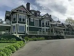 William M. Shaw House |
October 16, 2013 (#13000867) |
40 Norris St. 45°27′35″N 69°35′12″W |
Greenville | Now the Greenville Inn at Moosehead Lake. |
| 52 | Slate House | March 10, 1995 (#95000217) |
123 Church St. 45°18′52″N 69°01′46″W |
Brownville | Destroyed by fire 2019 | |
| 53 | Swedish Lutheran Church | 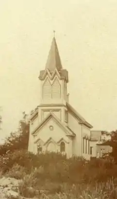 Swedish Lutheran Church |
July 19, 1984 (#84001489) |
Wilkins and Hebron Sts. 45°17′09″N 69°30′10″W |
Monson | |
| 54 | Tramway Historic District |  Tramway Historic District |
May 7, 1979 (#79000164) |
Northeast of Greenville 46°19′10″N 69°22′39″W |
Greenville | |
| 55 | James Sullivan Wiley House | 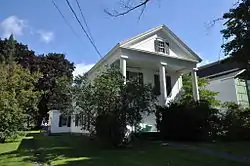 James Sullivan Wiley House |
November 21, 1976 (#76000111) |
Main St. 45°11′01″N 69°13′31″W |
Dover-Foxcroft | |
| 56 | Willard Brook Quarry | September 26, 1986 (#86002182) |
Address Restricted |
Chesuncook |
Former listings
| [3] | Name on the Register | Image | Date listed | Date removed | Location | City or town | Summary |
|---|---|---|---|---|---|---|---|
| 1 | Walter and Eva Burgess Farm | April 14, 1997 (#97000312) | July 14, 2015 | 257 Shaw Rd. 45°06′38″N 69°13′40″W |
Macomber Corner | Destroyed by fire in 2013. | |
| 2 | Low's (Lowes) Bridge | February 16, 1972 (#70000062) | May 12, 1987 | Over Piscataquis River between Guilford and Sangerville 45°10′31″N 69°18′54″W |
Guilford vicinity | 1857 covered bridge, washed away by a flood April 1, 1987;[6] bridge has been rebuilt. | |
| 3 | Straw House | February 19, 1982 (#82000776) | December 21, 2020 | 11A Golda Ct. 45°10′13″N 69°23′07″W |
Guilford | Recently known as the Trebor Mansion Inn; destroyed by fire in 2019.[7] |
See also
| Wikimedia Commons has media related to National Register of Historic Places in Piscataquis County, Maine. |
References
- The latitude and longitude information provided in this table was derived originally from the National Register Information System, which has been found to be fairly accurate for about 99% of listings. Some locations in this table may have been corrected to current GPS standards.
- "National Register of Historic Places: Weekly List Actions". National Park Service, United States Department of the Interior. Retrieved on February 5, 2021.
- Numbers represent an alphabetical ordering by significant words. Various colorings, defined here, differentiate National Historic Landmarks and historic districts from other NRHP buildings, structures, sites or objects.
- "National Register Information System". National Register of Historic Places. National Park Service. April 24, 2008.
- The eight-digit number below each date is the number assigned to each location in the National Register Information System database, which can be viewed by clicking the number.
- Maine DOT
- https://bangordailynews.com/2019/07/22/news/an-1832-inn-left-vacant-for-several-years-in-piscataquis-county-destroyed-in-blaze/
| Topics | |
|---|---|
| Lists by state |
|
| Lists by insular areas | |
| Lists by associated state | |
| Other areas | |
| Related | |
| |
Municipalities and communities of Piscataquis County, Maine, United States | ||
|---|---|---|
| Towns | Piscataquis County map | |
| Plantations | ||
| Unorganized territories | ||
| CDPs | ||
| Other villages | ||
| ||
This article is issued from Wikipedia. The text is licensed under Creative Commons - Attribution - Sharealike. Additional terms may apply for the media files.