National Register of Historic Places listings in Penobscot County, Maine
This is a list of properties on the National Register of Historic Places in Penobscot County, Maine.
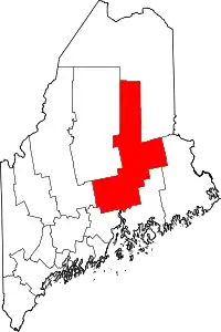
Location of Penobscot County in Maine
This is intended to be a complete list of the properties and districts on the National Register of Historic Places in Penobscot County, Maine, United States. Latitude and longitude coordinates are provided for many National Register properties and districts; these locations may be seen together in a map.[1]
There are 107 properties and districts listed on the National Register in the county. Five properties were once listed, but have since been removed from the register.
- This National Park Service list is complete through NPS recent listings posted February 5, 2021.[2]
| Androscoggin - Aroostook - Cumberland - Franklin - Hancock - Kennebec - Knox - Lincoln - Oxford - Penobscot - Piscataquis - Sagadahoc - Somerset - Waldo - Washington - York |
Current listings
| [3] | Name on the Register[4] | Image | Date listed[5] | Location | City or town | Description |
|---|---|---|---|---|---|---|
| 1 | Abbott Memorial Library | November 20, 1978 (#78000190) |
State Route 7 45°01′28″N 69°17′21″W |
Dexter | ||
| 2 | Adams-Pickering Block | 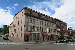 Adams-Pickering Block |
May 2, 1974 (#74000184) |
Corner of Main and Middle Sts. 44°47′59″N 68°46′20″W |
Bangor | |
| 3 | All Souls Congregational Church | 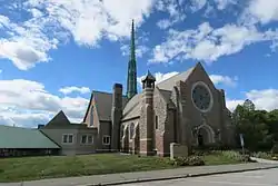 All Souls Congregational Church |
June 18, 1992 (#92000790) |
10 Broadway 44°48′09″N 68°46′04″W |
Bangor | |
| 4 | Harold Allan Schoolhouse | July 16, 2008 (#08000667) |
15 Rebel Hill Rd. 44°48′19″N 68°32′22″W |
Clifton | ||
| 5 | Archeological Site No. 122-6 | October 31, 1995 (#95001199) |
Address Restricted |
Millinocket | ||
| 6 | Archeological Site No. 122-8 | October 31, 1995 (#95001232) |
Address Restricted |
Millinocket | ||
| 7 | Archeological Site No. 122-14 | October 31, 1995 (#95001201) |
Address Restricted |
Millinocket | ||
| 8 | Archeological Site No. 122-16 | October 31, 1995 (#95001200) |
Address Restricted |
Millinocket | ||
| 9 | Archeological Site No. 122-22 | October 31, 1995 (#95001233) |
Address Restricted |
Millinocket | ||
| 10 | Archeological Site No. 134-8 | October 31, 1995 (#95001216) |
Address Restricted |
Millinocket | ||
| 11 | Archeological Site No. 134-9 | October 31, 1995 (#95001217) |
Address Restricted |
Millinocket | ||
| 12 | Bangor Children's Home |  Bangor Children's Home |
September 9, 1975 (#75000103) |
218 Ohio St. 44°48′27″N 68°46′52″W |
Bangor | |
| 13 | Bangor Fire Engine House No. 6 | 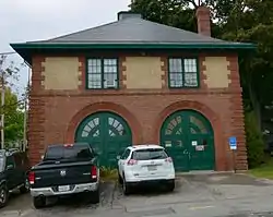 Bangor Fire Engine House No. 6 |
April 7, 1988 (#88000394) |
284 Center St. 44°48′49″N 68°46′24″W |
Bangor | |
| 14 | Bangor Hose House No. 5 | 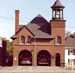 Bangor Hose House No. 5 |
September 11, 1997 (#97001130) |
247 State St. 44°48′21″N 68°45′36″W |
Bangor | |
| 15 | Bangor House | 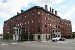 Bangor House |
February 23, 1972 (#72000076) |
174 Main St. 44°47′54″N 68°46′21″W |
Bangor | |
| 16 | Bangor Mental Health Institute | 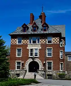 Bangor Mental Health Institute |
July 16, 1987 (#87000420) |
656 State St. 44°49′02″N 68°44′31″W |
Bangor | |
| 17 | Bangor Standpipe | 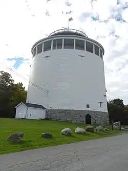 Bangor Standpipe |
August 30, 1974 (#74000185) |
Jackson St. 44°48′27″N 68°46′58″W |
Bangor | |
| 18 | Bangor Theological Seminary Historic District | 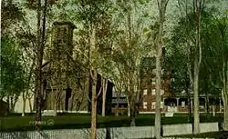 Bangor Theological Seminary Historic District |
August 2, 1977 (#77000080) |
Union St. 44°48′07″N 68°46′48″W |
Bangor | |
| 19 | Bank Block | March 25, 1999 (#99000375) |
15 Main St. 45°01′28″N 69°17′29″W |
Dexter | ||
| 20 | Battleship Maine Monument | 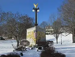 Battleship Maine Monument |
October 8, 1999 (#99001187) |
Junction of Main and Cedar Sts. 44°47′51″N 68°46′26″W |
Bangor | |
| 21 | Blake House | .jpg.webp) Blake House |
October 31, 1972 (#72000077) |
107 Court St. 44°48′13″N 68°46′37″W |
Bangor | |
| 22 | Bodwell Water Power Company Plant | September 29, 1988 (#88001842) |
Eastern side of the Penobscot River at Bridge St. 44°56′28″N 68°38′53″W |
Milford | ||
| 23 | Bradford Farm Historic District | April 22, 2003 (#03000294) |
46 Main St. (SR 11) 45°59′56″N 68°26′51″W |
Patten | Now a bed and breakfast | |
| 24 | Brewer High School | 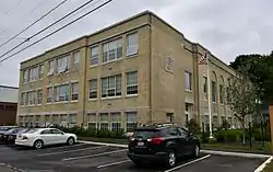 Brewer High School |
October 8, 2014 (#14000838) |
5 Somerset St. 44°47′31″N 68°45′35″W |
Brewer | |
| 25 | Broadway Historic District | May 7, 1973 (#73000244) |
Bounded by Garland, Essex, State, Park, and Center Sts. 44°48′18″N 68°46′05″W |
Bangor | ||
| 26 | Charles G. Bryant Double House | 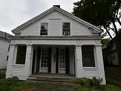 Charles G. Bryant Double House |
June 20, 1986 (#86001338) |
16-18 Division St. 44°48′31″N 68°46′33″W |
Bangor | |
| 27 | Building at 84–96 Hammond Street | 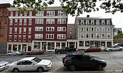 Building at 84–96 Hammond Street |
August 5, 2005 (#05000797) |
84–96 Hammond St. 44°48′05″N 68°46′22″W |
Bangor | |
| 28 | Louis I. Bussey School | November 7, 1976 (#76000108) |
U.S. Route 202 44°40′50″N 69°09′45″W |
Dixmont | ||
| 29 | Cliffwood Hall | July 16, 2008 (#08000666) |
15 Rebel Hill Rd. 44°48′18″N 68°32′22″W |
Clifton | ||
| 30 | William Colburn House |  William Colburn House |
June 19, 1973 (#73000134) |
91 Bennoch Rd. 44°53′19″N 68°40′42″W |
Orono | |
| 31 | Colonial Apartments | 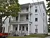 Colonial Apartments |
December 19, 2012 (#12001067) |
51-53 High St. 44°48′00″N 68°46′27″W |
Bangor | |
| 32 | Congregational Church of Medway | November 21, 1977 (#77000081) |
Off State Route 11 45°36′20″N 68°31′39″W |
Medway | ||
| 33 | Connors House | 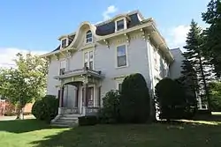 Connors House |
October 6, 1983 (#83003669) |
277 State St. 44°48′21″N 68°45′33″W |
Bangor | |
| 34 | Corinth Town Hall and Corinthian Lodge No. 59, I.O.O.F. | 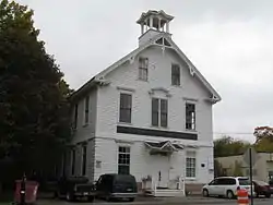 Corinth Town Hall and Corinthian Lodge No. 59, I.O.O.F. |
January 24, 2008 (#07001446) |
328 Main St. 45°00′08″N 69°01′22″W |
Corinth | |
| 35 | Corinth Village | June 4, 1973 (#73000135) |
3.5 miles west of East Corinth 44°57′20″N 69°01′23″W |
East Corinth | ||
| 36 | John B. Curtis Free Public Library | April 14, 1997 (#97000310) |
Northeastern corner of the junction of State Routes 11 and 221 45°04′03″N 68°56′13″W |
Bradford | ||
| 37 | Abial Cushman Store | December 18, 1990 (#90001906) |
Main St. east of State Route 168 45°21′36″N 68°17′10″W |
Lee | ||
| 38 | Dexter Grist Mill | October 10, 1975 (#75000104) |
State Route 7 45°01′23″N 69°17′29″W |
Dexter | ||
| 39 | Dexter Universalist Church | June 20, 1985 (#85001258) |
Church St. 45°01′29″N 69°17′22″W |
Dexter | ||
| 40 | District No. 2 School | 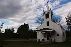 District No. 2 School |
April 15, 1997 (#97000309) |
Southeastern corner of the junction of Pleasant St. and Caribou Rd. 45°11′07″N 68°36′51″W |
Passadumkeag | |
| 41 | District No. 5 School House | September 11, 1997 (#97001131) |
Billings Rd., 0.15 miles northeast of the junction of U.S. Route 2 and Billings Rd. 44°48′42″N 68°54′36″W |
Hermon | ||
| 42 | Dixmont Corner Church | 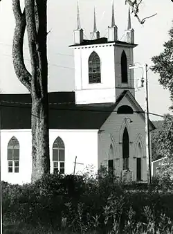 Dixmont Corner Church |
July 21, 1983 (#83000468) |
U.S. Route 202 44°40′50″N 69°09′42″W |
Dixmont | |
| 43 | Dixmont Town House | June 27, 2014 (#14000361) |
702 Western Ave. 44°41′06″N 69°08′03″W |
Dixmont | ||
| 44 | East Eddington Public Hall | 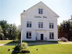 East Eddington Public Hall |
January 28, 2004 (#03001503) |
Airline Rd., 0.4 miles west of its junction with State Route 46, S. 44°47′32″N 68°35′11″W |
Eddington | |
| 45 | Eddington Bend (Site 74-8) | September 28, 1988 (#88000937) |
Address Restricted |
Eddington | ||
| 46 | Enterprise Grange, No. 173 | January 24, 2008 (#07001447) |
446 Dow Rd. 44°43′14″N 68°47′20″W |
Orrington | ||
| 47 | Samuel Farrar House | May 23, 1974 (#74000186) |
123 Court St. 44°48′15″N 68°46′39″W |
Bangor | ||
| 48 | Gordon Fox Ranch | 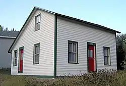 Gordon Fox Ranch |
November 9, 2015 (#15000769) |
680 W. Broadway 45°20′34″N 68°33′48″W |
Lincoln | |
| 49 | Garland Grange Hall | May 12, 1975 (#75000105) |
Off State Route 94 45°02′27″N 69°09′38″W |
Garland | ||
| 50 | Godfrey-Kellogg House | 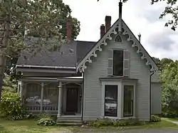 Godfrey-Kellogg House |
June 18, 1973 (#73000136) |
212 Kenduskeag Ave. 44°48′54″N 68°47′01″W |
Bangor | |
| 51 | Grand Army Memorial Home | 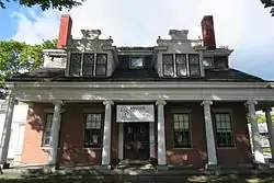 Grand Army Memorial Home |
October 31, 1972 (#72000105) |
159 Union St. 44°47′59″N 68°46′30″W |
Bangor | |
| 52 | Great Fire of 1911 Historic District | _Bangor%252C_Maine.JPG.webp) Great Fire of 1911 Historic District |
June 14, 1984 (#84001479) |
Harlow, Center, Park, State, York, and Central Sts. 44°48′11″N 68°46′12″W |
Bangor | |
| 53 | Gut Island Site | March 17, 1994 (#94000182) |
Address Restricted |
Old Town | ||
| 54 | Hannibal Hamlin House | 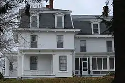 Hannibal Hamlin House |
October 9, 1979 (#79000160) |
15 5th St. 44°48′02″N 68°46′50″W |
Bangor | |
| 55 | Hammond Street Congregation Church | 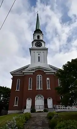 Hammond Street Congregation Church |
July 8, 1982 (#82000774) |
Hammond and High Sts. 44°48′04″N 68°46′28″W |
Bangor | |
| 56 | Hampden Academy | 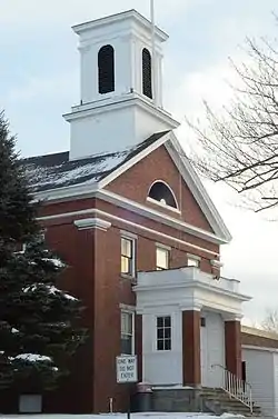 Hampden Academy |
September 11, 1975 (#75000106) |
1 Main Road North 44°44′24″N 68°50′17″W |
Hampden | 1842 Greek Revival school building |
| 57 | Hampden Congregational Church | 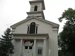 Hampden Congregational Church |
June 25, 1987 (#87000921) |
Main Rd., N. 44°44′47″N 68°50′12″W |
Hampden | |
| 58 | Harmony Hall | June 27, 2007 (#07000596) |
24 Kennebec Rd. 44°43′57″N 68°50′40″W |
Hampden | ||
| 59 | Hexagon Barn | January 24, 1980 (#80000412) |
Spring and Railroad Sts. 44°50′04″N 69°16′34″W |
Newport | ||
| 60 | Hirundo Site |  Hirundo Site |
September 11, 1975 (#75000107) |
Hirundo Wildlife Refuge 44°59′27″N 68°46′58″W |
Old Town | |
| 61 | Holden Town Hall | June 27, 2014 (#14000362) |
723 Main Rd. 44°44′59″N 68°39′02″W |
Holden | ||
| 62 | Charles W. Jenkins House | 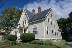 Charles W. Jenkins House |
September 18, 1990 (#90001469) |
67 Pine St. 44°48′10″N 68°45′59″W |
Bangor | |
| 63 | Jonas Cutting-Edward Kent House | 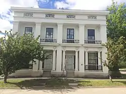 Jonas Cutting-Edward Kent House |
April 2, 1973 (#73000137) |
48-50 Penobscot St. 44°48′16″N 68°46′04″W |
Bangor | |
| 64 | Martin Kinsley House | April 14, 1983 (#83000469) |
83 Main Rd. S 44°44′02″N 68°50′28″W |
Hampden Highlands | Now home to the Hampden Historical Society. | |
| 65 | Jabez Knowlton Store | January 18, 1978 (#78000191) |
West of Newburgh on State Route 9 44°42′37″N 69°02′26″W |
Newburgh | A private museum, open by appointment. | |
| 66 | Joseph W. Low House | December 4, 1973 (#73000138) |
51 Highland St. 44°48′23″N 68°47′00″W |
Bangor | ||
| 67 | Maine Archeological Survey Site | January 26, 1984 (#84001486) |
Address Restricted |
Indian Island | Site #74-2 | |
| 68 | Maine Experiment Station Barn | 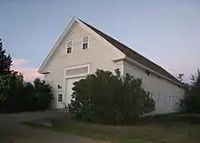 Maine Experiment Station Barn |
September 18, 1990 (#90001468) |
University of Maine campus 44°53′51″N 68°40′00″W |
Orono | Main building of the Page Farm & Home Museum |
| 69 | Mallett Hall | October 29, 1993 (#93001115) |
Northern side of State Route 6, 0.1 miles east of its junction with State Route 168 45°21′35″N 68°17′03″W |
Lee | ||
| 70 | Milford Congregational Church | July 13, 1989 (#89000841) |
Main and Ferry Sts. 44°56′48″N 68°38′42″W |
Milford | ||
| 71 | Morse & Co. Office Building | 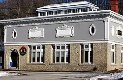 Morse & Co. Office Building |
April 2, 1973 (#73000139) |
455 Harlow St. 44°48′27″N 68°46′39″W |
Bangor | |
| 72 | Mount Hope Cemetery District |  Mount Hope Cemetery District |
December 4, 1974 (#74000187) |
U.S. Route 2 44°49′29″N 68°43′28″W |
Bangor | |
| 73 | North Newport Christian Church | June 20, 1995 (#95000726) |
Northeastern corner of the junction of State Route 222 and Pratt Rd. 44°53′29″N 69°12′25″W |
North Newport | ||
| 74 | Old Fire Engine House | 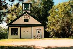 Old Fire Engine House |
September 12, 1985 (#85002181) |
N. Main St. 44°53′07″N 68°39′49″W |
Orono | |
| 75 | Old Tavern | April 4, 1986 (#86000674) |
State Route 188 and Old Dam Rd. 45°12′32″N 68°25′30″W |
Burlington | ||
| 76 | Orono Main Street Historic District | December 7, 1977 (#77000082) |
Main St. from Maplewood Ave. to Pine St. 44°52′40″N 68°40′38″W |
Orono | Contributing properties include Jeremiah Colburn House | |
| 77 | Edith Marion Patch House | 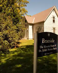 Edith Marion Patch House |
November 29, 2001 (#01001269) |
500 College Ave. 44°54′37″N 68°40′36″W |
Old Town | |
| 78 | Penobscot Expedition Site |  Penobscot Expedition Site |
April 23, 1973 (#73000140) |
In the Penobscot River |
Bangor and Brewer | Submerged archaeological remains of the 1779 Penobscot Expedition |
| 79 | Penobscot Salmon Club and Pool | September 15, 1976 (#76000109) |
N. Main St. 44°48′30″N 68°44′39″W |
North Brewer | ||
| 80 | Phi Gamma Delta House | 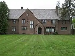 Phi Gamma Delta House |
April 16, 2013 (#13000169) |
79 College Ave. 44°53′31″N 68°40′22″W |
Orono | |
| 81 | Robyville Bridge | 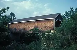 Robyville Bridge |
February 16, 1970 (#70000061) |
Over Kenduskeag Stream 44°56′35″N 68°58′08″W |
Robyville | |
| 82 | St. Anne's Church and Mission Site | 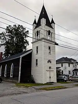 St. Anne's Church and Mission Site |
November 26, 1973 (#73000141) |
Down Street, on Indian Island off State Route 43 44°56′34″N 68°39′08″W |
Old Town | 1830 church for mission established in 1688 |
| 83 | St. James Episcopal Church | 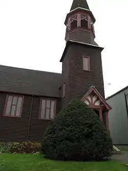 St. James Episcopal Church |
November 19, 1974 (#74000188) |
Centre St. 44°56′02″N 68°38′47″W |
Old Town | |
| 84 | St. John's Catholic Church |  St. John's Catholic Church |
April 2, 1973 (#73000142) |
York St. 44°48′13″N 68°45′40″W |
Bangor | |
| 85 | Daniel Sargent House | 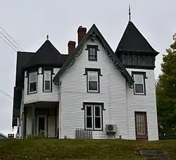 Daniel Sargent House |
October 29, 1982 (#82000425) |
613 S. Main St. 44°46′03″N 68°47′05″W |
Brewer | |
| 86 | Sargent-Roberts House | 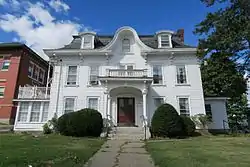 Sargent-Roberts House |
December 13, 1996 (#96001476) |
178 State St. 44°48′17″N 68°45′51″W |
Bangor | |
| 87 | Sebasticook Lake Fishweir Complex | November 10, 1994 (#94001245) |
Normally submerged in Sebasticook Lake |
Newport | ||
| 88 | George W. Smith Homestead | January 15, 1980 (#80000249) |
Main St. 45°30′59″N 68°21′13″W |
Mattawamkeag | ||
| 89 | Zebulon Smith House | 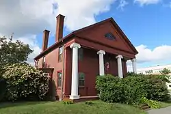 Zebulon Smith House |
January 21, 1974 (#74000189) |
55 Summer St. 44°47′47″N 68°46′24″W |
Bangor | |
| 90 | Springfield Congregational Church | December 22, 1978 (#78000193) |
State Route 6 45°23′45″N 68°08′16″W |
Springfield | ||
| 91 | Stetson Union Church | 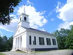 Stetson Union Church |
July 15, 1981 (#81000068) |
State Route 222 44°53′35″N 69°08′17″W |
Stetson | |
| 92 | Stewart Free Library |  Stewart Free Library |
July 30, 1974 (#74000190) |
State Routes 11/43 44°55′16″N 69°15′46″W |
Corinna | |
| 93 | Symphony House | 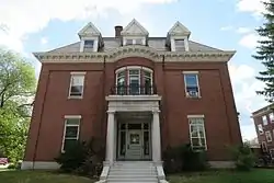 Symphony House |
October 26, 1972 (#72000078) |
166 Union St. 44°47′58″N 68°46′32″W |
Bangor | aka the Isaac Farrar Mansion; now owned by the YMCA. |
| 94 | Nathaniel Treat House | 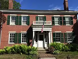 Nathaniel Treat House |
September 20, 1973 (#73000143) |
114 Main St. 44°52′48″N 68°39′48″W |
Orono | |
| 95 | United Baptist Church | October 4, 2018 (#100003011) |
53 Main Rd. 45°04′54″N 69°02′21″W |
Charleston | ||
| 96 | University of Maine at Orono Historic District |  University of Maine at Orono Historic District |
July 12, 1978 (#78000194) |
Munson, Sebec, and Schoodic Rds. 44°53′56″N 68°40′17″W |
Orono | Boundary increase (listed April 27, 2010): Roughly bounded by the Mall, College Ave, lower Munson and Long Rds. |
| 97 | US Post Office-Old Town Main | 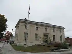 US Post Office-Old Town Main |
September 25, 1986 (#86002958) |
141 Center St. 44°56′05″N 68°38′48″W |
Old Town | |
| 98 | US Post Office-Orono Main | 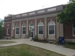 US Post Office-Orono Main |
May 2, 1986 (#86000881) |
Forest and Bennoch Sts. 44°53′02″N 68°40′23″W |
Orono | |
| 99 | Jones P. Veazie House | 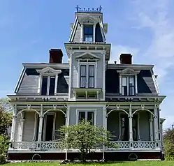 Jones P. Veazie House |
June 23, 1988 (#88000890) |
88 Fountain St. 44°48′45″N 68°46′38″W |
Bangor | |
| 100 | Wardwell-Trickey Double House | 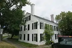 Wardwell-Trickey Double House |
June 18, 1992 (#92000795) |
97-99 Ohio St. 44°48′12″N 68°46′47″W |
Bangor | |
| 101 | Gov. Israel Washburn House | 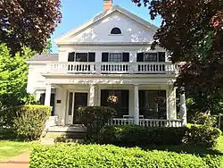 Gov. Israel Washburn House |
January 12, 1973 (#73000144) |
120 Main St. 44°52′37″N 68°40′40″W |
Orono | |
| 102 | West Market Square Historic District | 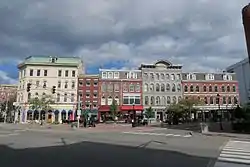 West Market Square Historic District |
December 27, 1979 (#79000161) |
W. Market Sq. 44°48′05″N 68°46′17″W |
Bangor | |
| 103 | Wheelwright Block | 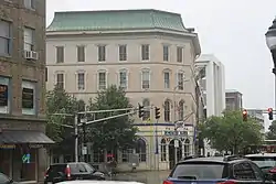 Wheelwright Block |
July 18, 1974 (#74000191) |
34 Hammond St. 44°48′05″N 68°46′16″W |
Bangor | |
| 104 | Whitney Park Historic District | 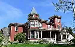 Whitney Park Historic District |
October 13, 1988 (#88001844) |
Roughly bounded by 8th, Union, Pond and Hayford Sts. 44°48′05″N 68°46′58″W |
Bangor | |
| 105 | Gen. John Williams House | 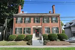 Gen. John Williams House |
December 22, 1978 (#78000195) |
62 High St. 44°47′58″N 68°46′28″W |
Bangor | |
| 106 | Young Site | March 26, 1976 (#76000110) |
Address Restricted |
Alton | Prehistoric archaeological site; listed in Hudson | |
| 107 | Zions Hill | October 16, 1989 (#89001705) |
37 Zions Hill 45°01′23″N 69°17′42″W |
Dexter |
Former listings
| [3] | Name on the Register | Image | Date listed | Date removed | Location | City or town | Summary |
|---|---|---|---|---|---|---|---|
| 1 | Collins Bridge Site | October 27, 1984 (#84000082) | March 6, 1987 | ME 178 |
Bradley vicinity | ||
| 2 | Romanzo Kingman House | February 19, 1982 (#82000775) | November 25, 2020 | Main St. 45°32′57″N 68°11′58″W |
Kingman | Destroyed by fire c. 2005.</ref>https://maineanencyclopedia.com/kingman/</ref> | |
| 3 | Morse Bridge | February 16, 1970 (#70000060) | September 29, 2015 | Valley Ave. over Kenduskeag Stream 44°48′28″N 68°46′43″W |
Bangor | Burned in the 1980s. | |
| 4 | Pierce Building | January 14, 1983[6] (#83000470) | March 9, 1984 | 23-37 Franklin St. |
Bangor | ||
| 5 | Charles H. Pond House | July 12, 1978 (#78000192) | December 22, 1986 | 175 State Street |
Bangor | Was disassembled for relocation to 46 Court Street in 1979.[7] Still in storage as of 1996[8] |
See also
| Wikimedia Commons has media related to National Register of Historic Places in Penobscot County, Maine. |
References
- The latitude and longitude information provided in this table was derived originally from the National Register Information System, which has been found to be fairly accurate for about 99% of listings. Some locations in this table may have been corrected to current GPS standards.
- "National Register of Historic Places: Weekly List Actions". National Park Service, United States Department of the Interior. Retrieved on February 5, 2021.
- Numbers represent an alphabetical ordering by significant words. Various colorings, defined here, differentiate National Historic Landmarks and historic districts from other NRHP buildings, structures, sites or objects.
- "National Register Information System". National Register of Historic Places. National Park Service. April 24, 2008.
- The eight-digit number below each date is the number assigned to each location in the National Register Information System database, which can be viewed by clicking the number.
- NRHP 1985 weekly listings
- Bangor Daily News
- Bangor Daily News (May 15, 1996)
| Topics | |
|---|---|
| Lists by state |
|
| Lists by insular areas | |
| Lists by associated state | |
| Other areas | |
| Related | |
| |
Municipalities and communities of Penobscot County, Maine, United States | ||
|---|---|---|
| Cities | Penobscot County map | |
| Towns |
| |
| Plantations | ||
| Unorganized territories | ||
| CDPs | ||
| Other villages | ||
| Indian reservation | ||
| ||
This article is issued from Wikipedia. The text is licensed under Creative Commons - Attribution - Sharealike. Additional terms may apply for the media files.