Naturita, Colorado
Naturita is a Statutory Town in Montrose County, Colorado, United States. The population was 546 at the 2010 census.
Town of Naturita, Colorado | |
|---|---|
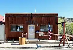 Town Hall on East Main Street | |
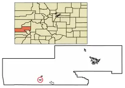 Location of Naturita in Montrose County, Colorado. | |
| Coordinates: 38°13′07″N 108°34′06″W[1] | |
| Country | United States |
| State | Colorado |
| County[2] | Montrose |
| Incorporated (town) | November 30, 1951[3] |
| Government | |
| • Type | Statutory Town[2] |
| Area | |
| • Total | 0.61 sq mi (1.59 km2) |
| • Land | 0.61 sq mi (1.59 km2) |
| • Water | 0.00 sq mi (0.00 km2) |
| Elevation | 5,417 ft (1,651 m) |
| Population (2010) | |
| • Total | 546 |
| • Estimate (2019)[5] | 532 |
| • Density | 865.04/sq mi (333.74/km2) |
| Time zone | UTC-7 (Mountain (MST)) |
| • Summer (DST) | UTC-6 (MDT) |
| ZIP code[6] | 81422 |
| Area code(s) | 970 |
| FIPS code | 08-53120 |
| GNIS feature ID | 2413035[1] |
| Website | townofnaturita |
A post office called Naturita has been in operation since 1882.[7] Naturita is a name derived from Spanish meaning "little nature".[8]
Geography
The community is located in southwest Montrose County within the San Miguel River valley. The community is served by Colorado State Highways 97 and 141.[9]
According to the United States Census Bureau, the town has a total area of 0.7 square miles (1.8 km2), all of it land. Naturita is located in an area of desert land, surrounding the Uncompahgre National Forest in western Colorado.
Climate
The average low in January is 16 °F (−9 °C), while the average high in July rises to 96 °F (36 °C). The record low temperature for the town is −23 °F (−31 °C), while the hottest temperature recorded is 115 °F (46 °C)[10]
Demographics
| Historical population | |||
|---|---|---|---|
| Census | Pop. | %± | |
| 1960 | 979 | — | |
| 1970 | 820 | −16.2% | |
| 1980 | 819 | −0.1% | |
| 1990 | 434 | −47.0% | |
| 2000 | 635 | 46.3% | |
| 2010 | 546 | −14.0% | |
| 2019 (est.) | 532 | [5] | −2.6% |
| U.S. Decennial Census[11] | |||
As of the census[12] of 2000, there were 635 people, 257 households, and 164 families residing in the town. The population density was 865.5 people per square mile (335.9/km2). There were 314 housing units at an average density of 428.0 per square mile (166.1/km2). The racial makeup of the town was 93.70% White, 2.36% Native American, 0.16% Asian, 1.73% from other races, and 2.05% from two or more races. Hispanic or Latino of any race were 5.04% of the population.
There were 257 households, out of which 35.4% had children under the age of 18 living with them, 44.7% were married couples living together, 12.8% had a female householder with no husband present, and 35.8% were non-families. 28.4% of all households were made up of individuals, and 13.6% had someone living alone who was 65 years of age or older. The average household size was 2.46 and the average family size was 3.06.
In the town, the population was spread out, with 29.6% under the age of 18, 7.9% from 18 to 24, 27.2% from 25 to 44, 21.7% from 45 to 64, and 13.5% who were 65 years of age or older. The median age was 36 years. For every 100 females, there were 95.4 males. For every 100 females age 18 and over, there were 105.0 males.
The median income for a household in the town was $28,977, and the median income for a family was $37,917. Males had a median income of $33,203 versus $15,625 for females. The per capita income for the town was $13,867. About 3.8% of families and 10.0% of the population were below the poverty line, including 6.1% of those under age 18 and 11.8% of those age 65 or over.
Amenities
Naturita has an inn, cafe, gas station, bank, grocery store and a few motels. To the west along Highway 90 in the community of Bedrock is the historic Bedrock Store, where scenes from movies such as Thelma and Louise were filmed.[13]
References
- U.S. Geological Survey Geographic Names Information System: Naturita, Colorado
- "Active Colorado Municipalities". State of Colorado, Department of Local Affairs. Archived from the original on 2009-12-12. Retrieved 2007-09-01.
- "Colorado Municipal Incorporations". State of Colorado, Department of Personnel & Administration, Colorado State Archives. 2004-12-01. Retrieved 2007-09-02.
- "2019 U.S. Gazetteer Files". United States Census Bureau. Retrieved July 1, 2020.
- "Population and Housing Unit Estimates". United States Census Bureau. May 24, 2020. Retrieved May 27, 2020.
- "ZIP Code Lookup". United States Postal Service. Archived from the original (JavaScript/HTML) on January 1, 2008. Retrieved November 25, 2007.
- "Post offices". Jim Forte Postal History. Retrieved 1 July 2016.
- Dawson, John Frank. Place names in Colorado: why 700 communities were so named, 150 of Spanish or Indian origin. Denver, CO: The J. Frank Dawson Publishing Co. p. 37.
- Naturita, CO., 7.5 Minute Topographic Quadrangle, USGS, 1994
- https://weather.com/weather/monthly/l/1b47f66cb133a726a88c265d7472a1085674767eab2981d3ff27a505893bb00a
- "Census of Population and Housing". Census.gov. Retrieved June 4, 2015.
- "U.S. Census website". United States Census Bureau. Retrieved 2008-01-31.
- Naturita information from Colorado.com
External links
Municipalities and communities of Montrose County, Colorado, United States | ||
|---|---|---|
| City |  Map of Colorado highlighting Montrose County | |
| Towns | ||
| CDP | ||
| Unincorporated communities | ||
| Ghost town | ||
| ||

