Prud'homme, Saskatchewan
Prud'homme (2016 population: 167) is a village in the Canadian province of Saskatchewan within the Rural Municipality of Bayne No. 371 and Census Division No. 15. It is approximately 60 kilometres (37 miles) northeast of Saskatoon. Prud'homme was first known by the name of Bluebell Ranch, then Lally Siding. In 1905 the railroad came through and renamed it Marcotte's Crossing, two years later it became known as Howell, and finally in 1922 it was later named after the bishop Msgr. Joseph H. Prud'homme.[5] The community is mostly based on agriculture.
Prud'homme | |
|---|---|
Village | |
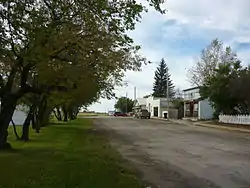 Railway Avenue | |
 Prud'homme  Prud'homme | |
| Coordinates: 52.337°N 105.893°W | |
| Country | Canada |
| Province | Saskatchewan |
| Region | Saskatchewan |
| Census division | 15 |
| Rural Municipality | Bayne |
| Post office Founded | February 1, 1906 |
| Incorporated (Village) | 1908 |
| Government | |
| • Mayor | Bamford Hounjet |
| • Administrator | Michelle Grimard |
| • Governing body | Prud'homme Village Council |
| Area | |
| • Total | 0.84 km2 (0.32 sq mi) |
| Population (2006) | |
| • Total | 167 |
| • Density | 198.7/km2 (515/sq mi) |
| Time zone | CST |
| Postal code | S0K 3K0 |
| Area code(s) | 306 |
| Highways | Highway 27 |
| Website | Village of Prud'homme |
| [1][2][3][4] | |
Main attractions: Town jail, Jeanne Sauvé park, Museum, The Let Go, Robinhood tree and Wildlife conservation area (Ducks unlimited)
History
Prud'homme incorporated as a village on November 15, 1922.[6]
Demographics
In the 2016 Census of Population conducted by Statistics Canada, the Village of Prud'homme recorded a population of 167 living in 71 of its 78 total private dwellings, a -3% change from its 2011 population of 172. With a land area of 0.84 km2 (0.32 sq mi), it had a population density of 198.8/km2 (514.9/sq mi) in 2016.[9]
In the 2011 Census of Population, the Village of Prud'homme recorded a population of 172, a 3% change from its 2006 population of 167. With a land area of 0.84 km2 (0.32 sq mi), it had a population density of 204.8/km2 (530.3/sq mi) in 2011.[10]
Notable people
- Maurice Baudoux, Bishop of Saint Boniface
- Anthony Bidulka, author
- Jeanne Sauvé, former Governor General of Canada, first female at this position
- Jordan Tkatch, Former Prince Albert Raider defensive forward of the year
- Brandon Tkatch, international industrial arts teacher
References
- National Archives, Archivia Net, Post Offices and Postmasters
- Government of Saskatchewan, MRD Home. "Municipal Directory System". Retrieved 2013-11-25.
- Canadian Textiles Institute. (2005), CTI Determine your provincial constituency, archived from the original on 2007-09-11
- Commissioner of Canada Elections, Chief Electoral Officer of Canada (2005), Elections Canada On-line
- Russell, E. T. (1973), What's in a name?: Travelling through Saskatchewan with the story behind 1600 place-names (2 ed.), Western Producer Book Service, ISBN 978-0-919306-39-4
- "Urban Municipality Incorporations". Saskatchewan Ministry of Government Relations. Archived from the original on October 15, 2014. Retrieved June 1, 2020.
- "Saskatchewan Census Population" (PDF). Saskatchewan Bureau of Statistics. Archived from the original (PDF) on September 24, 2015. Retrieved May 31, 2020.
- "Saskatchewan Census Population". Saskatchewan Bureau of Statistics. Retrieved May 31, 2020.
- "Population and dwelling counts, for Canada, provinces and territories, and census subdivisions (municipalities), 2016 and 2011 censuses – 100% data (Saskatchewan)". Statistics Canada. February 8, 2017. Retrieved May 30, 2020.
- "Population and dwelling counts, for Canada, provinces and territories, and census subdivisions (municipalities), 2011 and 2006 censuses (Saskatchewan)". Statistics Canada. June 3, 2019. Retrieved May 30, 2020.
External links
- 2001 Community Profiles
- GeoNames Query
- Online Historical Map Digitization Project
- Post Offices and Postmasters - ArchiviaNet - Library and Archives Canada
- Prud'homme Village Council
- Saskatchewan Gen Web Region
- Saskatchewan Gen Web - One Room School Project
- Saskatchewan Roman Catholic Churches ~ Online Parish Registers ~ History >> Howell / Prud'homme
Places adjacent to Prud'homme, Saskatchewan | ||||||||||
|---|---|---|---|---|---|---|---|---|---|---|
| ||||||||||
| Cities | 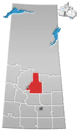 | ||
|---|---|---|---|
| Towns | |||
| Villages | |||
| Resort villages | |||
| Rural municipalities |
| ||
| First Nations | |||
| Indian reserves | |||
| Unincorporated communities |
| ||