Loreburn, Saskatchewan
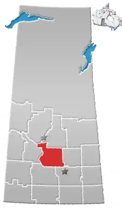
Loreburn (2016 population: 107) is a village in the Canadian province of Saskatchewan within the Rural Municipality of Loreburn No. 254 and Census Division No. 11. The village is 16 km north of Elbow and 16 km southeast of Danielson Provincial Park, which is located near Gardiner Dam, Lake Diefenbaker.
Loreburn | |
|---|---|
| Village of Loreburn | |
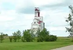 Grain elevator along the railway in Loreburn | |
 Location of Loreburn in Saskatchewan  Loreburn, Saskatchewan (Canada) | |
| Coordinates: 51.159°N 106.600°W | |
| Country | |
| Province | |
| Region | Central |
| Census division | 11 |
| Rural Municipality | Loreburn No. 254 |
| Post office Founded | 1908-11-21[1] |
| Incorporated (Village) | 1909 |
| Government | |
| • Type | Municipal |
| • Governing body | Loreburn Village Council |
| • Mayor | Steven South |
| • Administrator | Brandy Losie |
| Area | |
| • Total | 0.62 km2 (0.24 sq mi) |
| Population (2016) | |
| • Total | 113 |
| • Density | 231.4/km2 (599/sq mi) |
| Time zone | UTC-6 (CST) |
| Postal code | S0H 2S0 |
| Area code(s) | 306 |
| Highways | |
| Railways | Canadian Pacific Railway |
| [2][3][4][5] | |
Home of The 19ers Hockey Club. The 19ers Hockey Club is a Senior Hockey team that competes in the Sask Valley Hockey League (SVHL) winning championships in 1998 & 2000. The 19ers play out of the Loreburn Arena, located at 419 Jamieson St, Loreburn, Sk. The Loreburn Arena is known to be one of, if not the coldest, indoor hockey rink in the world.
History
Loreburn incorporated as a village on May 20, 1909.[6]
Demographics
In the 2016 Census of Population conducted by Statistics Canada, the Village of Loreburn recorded a population of 107 living in 53 of its 55 total private dwellings, a 0% change from its 2011 population of 107. With a land area of 0.62 km2 (0.24 sq mi), it had a population density of 172.6/km2 (447.0/sq mi) in 2016.[9]
In the 2011 Census of Population, the Village of Loreburn recorded a population of 107, a -5.3% change from its 2006 population of 113. With a land area of 0.62 km2 (0.24 sq mi), it had a population density of 172.6/km2 (447.0/sq mi) in 2011.[10]
References
- http://www.bac-lac.gc.ca/eng/discover/postal-heritage-philately/post-offices-postmasters/Pages/item.aspx?IdNumber=15647&=&p_ID=0
- National Archives, Archivia Net, Post Offices and Postmasters, archived from the original on 2006-10-06
- Government of Saskatchewan, MRD Home, Municipal Directory System, archived from the original on November 21, 2008
- Canadian Textiles Institute. (2005), CTI Determine your provincial constituency, archived from the original on 2007-09-11
- Commissioner of Canada Elections, Chief Electoral Officer of Canada (2005), Elections Canada On-line, archived from the original on 2007-04-21
- "Urban Municipality Incorporations". Saskatchewan Ministry of Government Relations. Archived from the original on October 15, 2014. Retrieved June 1, 2020.
- "Saskatchewan Census Population" (PDF). Saskatchewan Bureau of Statistics. Archived from the original (PDF) on September 24, 2015. Retrieved May 31, 2020.
- "Saskatchewan Census Population". Saskatchewan Bureau of Statistics. Retrieved May 31, 2020.
- "Population and dwelling counts, for Canada, provinces and territories, and census subdivisions (municipalities), 2016 and 2011 censuses – 100% data (Saskatchewan)". Statistics Canada. February 8, 2017. Retrieved May 30, 2020.
- "Population and dwelling counts, for Canada, provinces and territories, and census subdivisions (municipalities), 2011 and 2006 censuses (Saskatchewan)". Statistics Canada. June 3, 2019. Retrieved May 30, 2020.
External links
Places adjacent to Loreburn, Saskatchewan | ||||||||||
|---|---|---|---|---|---|---|---|---|---|---|
| ||||||||||