Mankota
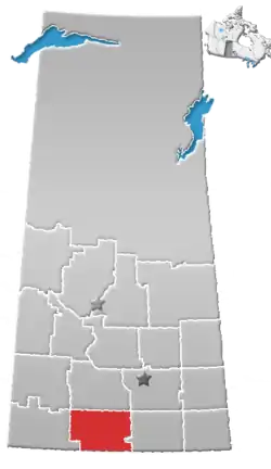
Mankota (2016 population: 205) is a village in the Canadian province of Saskatchewan within the Rural Municipality of Mankota No. 45 and Census Division No. 3. The village is located on Highway 18, about 150 km southeast of the City of Swift Current. It is also near the villages of Kincaid, Ferland, Hazenmore, and Glentworth.
Mankota | |
|---|---|
| Village of Mankota | |
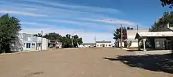 Businesses on 3rd Street West | |
 Mankota  Mankota  Mankota | |
| Coordinates: 49.421°N 107.070°W | |
| Country | Canada |
| Province | Saskatchewan |
| Region | Saskatchewan |
| Census division | No. 3 |
| Rural Municipality | Mankota No. 45 |
| Post office Founded | 1911 |
| Village Incorporated | N/A |
| Town Incorporated | N/A |
| Government | |
| • Mayor | Grant Martin |
| • Administrator | April Williamson |
| Area | |
| • Total | 1.55 km2 (0.60 sq mi) |
| Population (2011) | |
| • Total | 211 |
| • Density | 153.3/km2 (397/sq mi) |
| Time zone | CST |
| Postal code | S0H 2W0 |
| Area code(s) | 306 |
| Highways | Highway 18 Highway 19 |
History
The community acquired a post office in 1911 and was named by combining Manitoba and North Dakota, the original homes of many of its initial settlers.[1] Mankota incorporated as a village on February 3, 1941.[2]
Demographics
In the 2016 Census of Population conducted by Statistics Canada, the Village of Mankota recorded a population of 205 living in 107 of its 137 total private dwellings, a -2.9% change from its 2011 population of 211. With a land area of 1.42 km2 (0.55 sq mi), it had a population density of 144.4/km2 (373.9/sq mi) in 2016.[5]
In the 2011 Census of Population, the Village of Mankota recorded a population of 211, a -11.3% change from its 2006 population of 238. With a land area of 1.55 km2 (0.60 sq mi), it had a population density of 136.1/km2 (352.6/sq mi) in 2011.[6]
Economy
In 2016, Weil Group Resources of Dallas constructed a $10 million helium processing facility near Mankota to supply refined, industrial-grade helium gas to world markets, reviving a mineral resource which was previously established here in Saskatchewan.[7]
Education
Mankota has one school that covers Kindergarten through grade 12 in the Prairie South School Division. Enrollment for the 2008-2009 year is at about 78. The population of the school in 2011 is 61.
Attractions
- Grasslands National Park, one of Canada's newer national parks and is located in southern Saskatchewan along the Montana border.
- Cypress Hills Interprovincial Park, straddling the Alberta-Saskatchewan border southeast of Medicine Hat, is Canada's only interprovincial park.
- Mankota Stockyards, has cow sales every Friday all year long.
- Birthplace of photographer Neil O Webster.
- The Mankota Rodeo is held in May every year.
Climate
| Climate data for Mankota | |||||||||||||
|---|---|---|---|---|---|---|---|---|---|---|---|---|---|
| Month | Jan | Feb | Mar | Apr | May | Jun | Jul | Aug | Sep | Oct | Nov | Dec | Year |
| Record high °C (°F) | 12.8 (55.0) |
18 (64) |
23 (73) |
30.5 (86.9) |
37 (99) |
41 (106) |
38 (100) |
39.5 (103.1) |
36 (97) |
33 (91) |
21.7 (71.1) |
12.8 (55.0) |
41 (106) |
| Average high °C (°F) | −7.3 (18.9) |
−3.7 (25.3) |
3.1 (37.6) |
12 (54) |
18.6 (65.5) |
22.9 (73.2) |
26.8 (80.2) |
26.7 (80.1) |
19.9 (67.8) |
12.8 (55.0) |
1.3 (34.3) |
−5.3 (22.5) |
10.6 (51.1) |
| Daily mean °C (°F) | −13.6 (7.5) |
−9.8 (14.4) |
−3.1 (26.4) |
4.7 (40.5) |
11 (52) |
15.4 (59.7) |
18.5 (65.3) |
17.9 (64.2) |
11.5 (52.7) |
4.9 (40.8) |
−5.1 (22.8) |
−11.6 (11.1) |
3.4 (38.1) |
| Average low °C (°F) | −19.8 (−3.6) |
−15.9 (3.4) |
−9.4 (15.1) |
−2.6 (27.3) |
3.3 (37.9) |
7.8 (46.0) |
10.1 (50.2) |
9.1 (48.4) |
3.1 (37.6) |
−3 (27) |
−11.3 (11.7) |
−17.7 (0.1) |
−3.9 (25.0) |
| Record low °C (°F) | −43.3 (−45.9) |
−40 (−40) |
−33 (−27) |
−28.3 (−18.9) |
−15 (5) |
−5 (23) |
0.6 (33.1) |
−2.2 (28.0) |
−14 (7) |
−28 (−18) |
−38.5 (−37.3) |
−42.8 (−45.0) |
−43.3 (−45.9) |
| Average precipitation mm (inches) | 17.6 (0.69) |
14.5 (0.57) |
17.5 (0.69) |
20.8 (0.82) |
56.9 (2.24) |
58.2 (2.29) |
53 (2.1) |
29 (1.1) |
26.6 (1.05) |
15.2 (0.60) |
16 (0.6) |
15.1 (0.59) |
340.4 (13.40) |
| Source: Environment Canada[8] | |||||||||||||
See also
- List of villages in Saskatchewan
- List of geographic names derived from portmanteaus
References
- Barry, Bill (September 2005). Geographic Names of Saskatchewan. Regina, Saskatchewan: People Places Publishing, Ltd. p. 270. ISBN 1-897010-19-2.
- "Urban Municipality Incorporations". Saskatchewan Ministry of Government Relations. Archived from the original on October 15, 2014. Retrieved June 1, 2020.
- "Saskatchewan Census Population" (PDF). Saskatchewan Bureau of Statistics. Archived from the original (PDF) on September 24, 2015. Retrieved May 31, 2020.
- "Saskatchewan Census Population". Saskatchewan Bureau of Statistics. Retrieved May 31, 2020.
- "Population and dwelling counts, for Canada, provinces and territories, and census subdivisions (municipalities), 2016 and 2011 censuses – 100% data (Saskatchewan)". Statistics Canada. February 8, 2017. Retrieved May 30, 2020.
- "Population and dwelling counts, for Canada, provinces and territories, and census subdivisions (municipalities), 2011 and 2006 censuses (Saskatchewan)". Statistics Canada. June 3, 2019. Retrieved May 30, 2020.
- "Mankota". Weil Group Resources. Weil Group. Retrieved 29 December 2017.
- Environment Canada Canadian Climate Normals 1971–2000, accessed 10 September 2010
Places adjacent to Mankota | ||||||||||
|---|---|---|---|---|---|---|---|---|---|---|
| ||||||||||