Ashley River Historic District
Ashley River Historic District is a historic district located in the South Carolina Lowcountry near Charleston, South Carolina, United States. The Historic District includes land from five municipalities, almost equally split between Charleston and Dorchester counties. The district includes dry land, swamps, and marshes of the Rantowles Creek and Stono Swamp watershed.[2][3][4]
Ashley River Historic District | |
 Ashley River Road 1.8 mi N of Bees Ferry Rd | |
  | |
| Nearest city | Charleston, South Carolina and North Charleston, South Carolina |
|---|---|
| Coordinates | 32°54′45″N 80°07′22″W |
| Area | 23,828.26 acres (9,642.95 ha) |
| Architectural style | Georgian, Italianate |
| NRHP reference No. | 93001514[1] |
| Significant dates | |
| Added to NRHP | September 12, 1994 |
| Boundary increase | October 22, 2010 |
The historic district includes historic and archaeological resources associated with the rice culture and phosphate mining of the early-eighteenth century to the mid-nineteenth century, and the hunting plantations and timber industry preserves of the late nineteenth century through the mid-twentieth century. Historically, the Wando, Cooper, Ashley, Stono, and Edisto rivers served as the primary transportation routes in the Lowcountry. These waterways were used for exploration and settlement, the movement of goods, and the cultivation of staple crops.[3]
It was listed on the National Register of Historic Places in 1994. Its boundaries were increased from 7,000 acres to 23,828.26 acres on October 22, 2010.[1]
It includes some of the following separately listed sites as contributing properties:[5]
- Ashley River
- Ashley River Road
- Fort Bull
- Atlantic Coast Line Railroad Trestle
- Drayton Hall, a National Historic Landmark;
- Magnolia Plantation and Gardens (Charleston, South Carolina);
- Runnymeade Schoolhouse
- Middleton Place, another National Historic Landmark
- Old Dorchester;
- The Laurels
Gallery
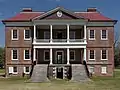 Drayton Hall, front view
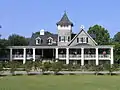 House at Magnolia Plantation
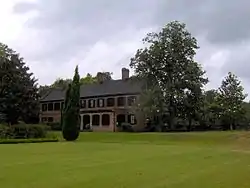 Middleton Place
 Ruins of the St. George Bell Tower at Old Dorchester
References
- "National Register Information System". National Register of Historic Places. National Park Service. July 9, 2010.
- Power, J. Tracy; Ian G. Hill; L.G. Tippett (July 26, 1994). "Ashley River Historic District" (pdf). National Register of Historic Places - Nomination and Inventory. Retrieved 9 June 2012.
- "Ashley River Historic District (Boundary Increase)" (pdf). National Register of Historic Places - Nomination and Inventory. July 26, 1994. Retrieved 9 June 2012.
- "Ashley River Historic District, Charleston and Dorchester County (along Ashley River & S.C. Hwy. 61, Charleston & Summerville vicinities, Charleston & Dorchester Counties)". National Register Properties in South Carolina. South Carolina Department of Archives and History. Retrieved 9 June 2012.
- "National Register Properties in South Carolina". South Carolina Department of Archives and History. Retrieved October 20, 2017.
External links
 Media related to Ashley River Historic District at Wikimedia Commons
| Topics |  | |
|---|---|---|
| Lists by county |
| |
| Lists by city |
| |
| Other lists | ||
