National Register of Historic Places listings in Coventry, Rhode Island
List of Registered Historic Places in Coventry, Rhode Island, which has been transferred from and is an integral part of National Register of Historic Places listings in Kent County, Rhode Island
Bristol | Kent | Newport | Providence | Washington |
- This National Park Service list is complete through NPS recent listings posted January 29, 2021.[1]
| [2] | Name on the Register[3] | Image | Date listed[4] | Location | City or town | Description |
|---|---|---|---|---|---|---|
| 1 | Anthony Village Historic District | 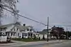 Anthony Village Historic District |
September 20, 2010 (#10000770) |
Washington St. between Battey Ave. and Hazard St. and various properties on 12 adjacent streets and the Pawtuxet River 41°41′39″N 71°33′13″W |
Coventry | |
| 2 | Arkwright Bridge | 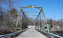 Arkwright Bridge |
December 12, 1978 (#78000061) |
Crosses the Pawtuxet River at Hill St.; closed. 41°43′49″N 71°32′49″W |
Coventry | Extends into Providence County |
| 3 | Isaac Bowen House |  Isaac Bowen House |
June 27, 1980 (#80000076) |
Northeast of Coventry on Maple Valley Rd. 41°43′09″N 71°41′53″W |
Coventry | |
| 4 | Joseph Briggs House-Coventry Town Farm | 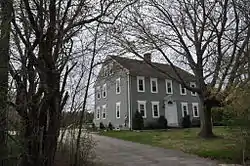 Joseph Briggs House-Coventry Town Farm |
June 18, 1987 (#87000997) |
Town Farm Rd. 41°42′30″N 71°36′55″W |
Coventry | |
| 5 | Carbuncle Hill Archaeological District, RI-1072-1079 | September 28, 1985 (#85002692) |
Address Restricted |
Coventry | ||
| 6 | Christopher Rhodes Greene House | 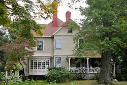 Christopher Rhodes Greene House |
August 30, 2007 (#07000891) |
2 Potter Court 41°43′49″N 71°32′25″W |
Coventry | |
| 7 | Gen. Nathanael Greene Homestead | 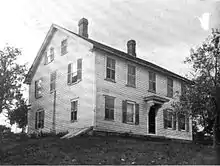 Gen. Nathanael Greene Homestead |
October 7, 1971 (#71000014) |
20 Taft St. 41°41′38″N 71°32′36″W |
Coventry | |
| 8 | Harris Mill | 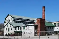 Harris Mill |
July 27, 2007 (#07000761) |
618 Main St. 41°43′29″N 71°32′11″W |
Coventry | |
| 9 | Hopkins Hollow Village |  Hopkins Hollow Village |
January 27, 2010 (#09001290) |
Hopkins Hollow Rd., Narrow Ln., and Perry Hill Rd. 41°40′59″N 71°45′06″W |
Coventry and West Greenwich | |
| 10 | Interlaken Mill Bridge | 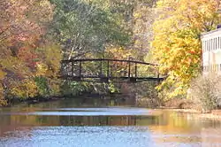 Interlaken Mill Bridge |
December 22, 1978 (#78000064) |
Spans the Pawtuxet River at Arkwright 41°43′41″N 71°32′39″W |
Coventry | |
| 11 | Moosup River Site (RI-1153) | December 10, 1987 (#87002083) |
Address Restricted |
Coventry | ||
| 12 | Paine House | 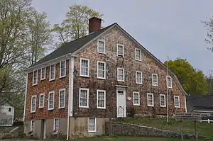 Paine House |
May 1, 1974 (#74000039) |
Station St. 41°41′29″N 71°33′54″W |
Coventry | |
| 13 | Pawtuxet Valley Dyeing Company | 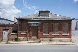 Pawtuxet Valley Dyeing Company |
November 16, 2005 (#05001296) |
9 Howard Ave. 41°43′25″N 71°32′17″W |
Coventry | |
| 14 | Read School | 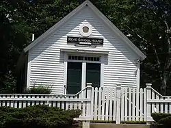 Read School |
March 20, 2002 (#02000231) |
1670 Flat River Rd. 41°42′20″N 71°35′50″W |
Coventry | |
| 15 | Rice City Historic District | 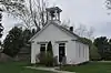 Rice City Historic District |
June 9, 1980 (#80000078) |
West of Coventry Center at RI 14 and RI 117 41°42′37″N 71°45′52″W |
Coventry | |
| 16 | South Main Street Historic District | 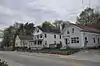 South Main Street Historic District |
July 10, 1987 (#87001064) |
Cady, S. Main, and Wood Sts. 41°41′17″N 71°34′03″W |
Coventry | |
| 17 | Waterman Tavern | 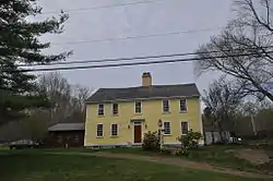 Waterman Tavern |
July 24, 1974 (#74000040) |
283 Maple Valley Rd. 41°43′10″N 71°39′37″W |
Coventry | |
| 18 | William Waterman House | 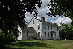 William Waterman House |
November 14, 1980 (#80000080) |
RI 102 41°42′13″N 71°41′51″W |
Coventry | |
| 19 | Wilson-Winslow House | 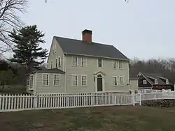 Wilson-Winslow House |
November 4, 1993 (#93001182) |
2414 Harkney Hill Rd. 41°41′09″N 71°40′45″W |
Coventry |
See also
References
- "National Register of Historic Places: Weekly List Actions". National Park Service, United States Department of the Interior. Retrieved on January 29, 2021.
- Numbers represent an alphabetical ordering by significant words. Various colorings, defined here, differentiate National Historic Landmarks and historic districts from other NRHP buildings, structures, sites or objects.
- "National Register Information System". National Register of Historic Places. National Park Service. March 13, 2009.
- The eight-digit number below each date is the number assigned to each location in the National Register Information System database, which can be viewed by clicking the number.
| Topics | _(extra_close)_(US48).svg.png.webp) | ||||||||||
|---|---|---|---|---|---|---|---|---|---|---|---|
| Lists by county | |||||||||||
| Lists by city |
| ||||||||||
| |||||||||||
This article is issued from Wikipedia. The text is licensed under Creative Commons - Attribution - Sharealike. Additional terms may apply for the media files.