National Register of Historic Places listings in East Greenwich, Rhode Island
List of Registered Historic Places in East Greenwich, Rhode Island, which has been transferred from and is an integral part of National Register of Historic Places listings in Kent County, Rhode Island
Bristol | Kent | Newport | Providence | Washington |
- This National Park Service list is complete through NPS recent listings posted January 29, 2021.[1]
| [2] | Name on the Register[3] | Image | Date listed[4] | Location | City or town | Description |
|---|---|---|---|---|---|---|
| 1 | Armory of the Kentish Guards |  Armory of the Kentish Guards |
April 28, 1970 (#70000012) |
Armory and Peirce Sts. 41°39′40″N 71°27′04″W |
East Greenwich | |
| 2 | Richard Briggs Farm |  Richard Briggs Farm |
June 6, 2003 (#03000517) |
830 South Rd. 41°36′25″N 71°30′38″W |
East Greenwich | |
| 3 | East Greenwich Historic District |  East Greenwich Historic District |
June 13, 1974 (#74000036) |
Roughly bounded by Kenyon Ave., Division, Peirce, and London Sts., Greenwich Cove and Dark Entry Brook 41°39′43″N 71°27′17″W |
East Greenwich and Warwick | |
| 4 | Fry's Hamlet Historic District |  Fry's Hamlet Historic District |
December 20, 1985 (#85003161) |
2068, 2153, 2196, and 2233 S. County Trail 41°38′21″N 71°29′58″W |
East Greenwich | |
| 5 | Kent County Courthouse |  Kent County Courthouse |
April 28, 1970 (#70000013) |
127 Main St. 41°39′39″N 71°27′02″W |
East Greenwich | Now East Greenwich Town Hall |
| 6 | Massie Wireless Station |  Massie Wireless Station |
October 22, 2001 (#01001157) |
1300 Frenchtown Rd. (New England Wireless and Steam Museum) 41°37′33″N 71°30′45″W |
East Greenwich | |
| 7 | Spencer–Shippee–Lillbridge House |  Spencer–Shippee–Lillbridge House |
April 20, 2011 (#11000207) |
12 Middle Rd. 41°39′16″N 71°27′51″W |
East Greenwich | |
| 8 | Tillinghast Mill Site | 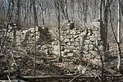 Tillinghast Mill Site |
March 10, 1988 (#88000164) |
Frenchtown Park 41°37′41″N 71°30′23″W |
East Greenwich | |
| 9 | Tillinghast Road Historic District |  Tillinghast Road Historic District |
March 9, 1988 (#88000167) |
Tillinghast Rd. 41°37′03″N 71°30′39″W |
East Greenwich | |
| 10 | Gen. James Mitchell Varnum House |  Gen. James Mitchell Varnum House |
August 12, 1971 (#71000016) |
57 Peirce St. 41°39′49″N 71°27′06″W |
East Greenwich | |
| 11 | Clement Weaver-Daniel Howland House | 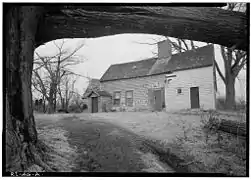 Clement Weaver-Daniel Howland House |
November 7, 1995 (#95001266) |
125 Howland Rd. 41°39′32″N 71°28′40″W |
East Greenwich | |
| 12 | Col. Micah Whitmarsh House | 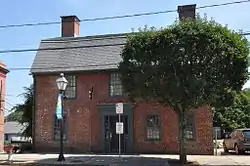 Col. Micah Whitmarsh House |
February 18, 1971 (#71000017) |
294 Main St. 41°39′34″N 71°27′01″W |
East Greenwich | |
| 13 | Windmill Cottage | 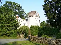 Windmill Cottage |
May 22, 1973 (#73000051) |
144 Division St. 41°39′49″N 71°27′23″W |
East Greenwich |
See also
References
- "National Register of Historic Places: Weekly List Actions". National Park Service, United States Department of the Interior. Retrieved on January 29, 2021.
- Numbers represent an alphabetical ordering by significant words. Various colorings, defined here, differentiate National Historic Landmarks and historic districts from other NRHP buildings, structures, sites or objects.
- "National Register Information System". National Register of Historic Places. National Park Service. March 13, 2009.
- The eight-digit number below each date is the number assigned to each location in the National Register Information System database, which can be viewed by clicking the number.
| Topics | _(extra_close)_(US48).svg.png.webp) | ||||||||||
|---|---|---|---|---|---|---|---|---|---|---|---|
| Lists by county | |||||||||||
| Lists by city |
| ||||||||||
| |||||||||||
Municipalities and communities of Kent County, Rhode Island, United States | ||
|---|---|---|
| City |  Map of Rhode Island highlighting Kent County | |
| Towns | ||
| CDP | ||
| Villages | ||
| ||
This article is issued from Wikipedia. The text is licensed under Creative Commons - Attribution - Sharealike. Additional terms may apply for the media files.