National Register of Historic Places listings in Glocester, Rhode Island
This is a list of Registered Historic Places in Glocester, Rhode Island.
Bristol | Kent | Newport | Providence | Washington |
- This National Park Service list is complete through NPS recent listings posted February 5, 2021.[1]
| [2] | Name on the Register[3] | Image | Date listed[4] | Location | City or town | Description |
|---|---|---|---|---|---|---|
| 1 | Chepachet Village Historic District | 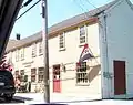 Chepachet Village Historic District |
March 31, 1971 (#71000031) |
Both sides of U.S. Route 44 (roughly from the intersection of U.S. Route 44 and RI 102 north to the intersection of RI 100 and RI 102) and radiating 41°54′46″N 71°40′00″W |
Glocester | |
| 2 | Cherry Valley Archeological Site, RI-279 | November 1, 1984 (#84000358) |
Address Restricted |
Glocester | ||
| 3 | Glocester Town Pound | 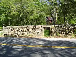 Glocester Town Pound |
September 22, 1970 (#70000021) |
Pound Rd. and Chopmist Hill Rd. 41°53′44″N 71°40′09″W |
Glocester | |
| 4 | Harmony Chapel and Cemetery | 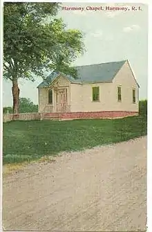 Harmony Chapel and Cemetery |
June 25, 1980 (#80000098) |
Putnam Pike 41°53′20″N 71°36′03″W |
Glocester | |
| 5 | Manton-Hunt-Farnum Farm |  Manton-Hunt-Farnum Farm |
October 3, 1985 (#85002735) |
Putnam Pike 41°53′54″N 71°37′15″W |
Glocester |
See also
References
- "National Register of Historic Places: Weekly List Actions". National Park Service, United States Department of the Interior. Retrieved on February 5, 2021.
- Numbers represent an alphabetical ordering by significant words. Various colorings, defined here, differentiate National Historic Landmarks and historic districts from other NRHP buildings, structures, sites or objects.
- "National Register Information System". National Register of Historic Places. National Park Service. March 13, 2009.
- The eight-digit number below each date is the number assigned to each location in the National Register Information System database, which can be viewed by clicking the number.
| Topics | _(extra_close)_(US48).svg.png.webp) | ||||||||||
|---|---|---|---|---|---|---|---|---|---|---|---|
| Lists by county | |||||||||||
| Lists by city |
| ||||||||||
| |||||||||||
This article is issued from Wikipedia. The text is licensed under Creative Commons - Attribution - Sharealike. Additional terms may apply for the media files.