National Register of Historic Places listings in Cranston, Rhode Island
This is a list of Registered Historic Places in Cranston, Rhode Island.
Bristol | Kent | Newport | Providence | Washington |
- This National Park Service list is complete through NPS recent listings posted January 29, 2021.[1]
| [2] | Name on the Register[3] | Image | Date listed[4] | Location | City or town | Description |
|---|---|---|---|---|---|---|
| 1 | Arkwright Bridge | 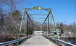 Arkwright Bridge |
December 12, 1978 (#78000061) |
Crosses the Pawtuxet River at Hill St. 41°43′49″N 71°32′49″W |
Cranston | Extends into Kent County |
| 2 | Edgewood Historic District-Anstis Greene Estate Plats |  Edgewood Historic District-Anstis Greene Estate Plats |
August 3, 2015 (#15000497) |
Anstis, Broad & Swift Sts., Birchfield & Kensington Rds., Bluff, King, Marion & Rosewood Aves., Narragansett Blvd. 41°46′25″N 71°23′40″W |
Cranston | |
| 3 | Edgewood Historic District-Arnold Farm Plat | 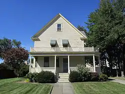 Edgewood Historic District-Arnold Farm Plat |
September 10, 2010 (#10000733) |
Arnold, Albert, Columbia Aves.; parts of Broad St., Pawtuxet Ave., Narragansett Blvd. 41°46′38″N 71°23′44″W |
Cranston | |
| 4 | Edgewood Historic District-Taft Estate Plat |  Edgewood Historic District-Taft Estate Plat |
October 24, 2003 (#03001069) |
Roughly bounded by Windsor Rd., Narragansett Bay, Circuit Dr., and Broad St.; E. side of Narragansett Blvd. between Windsor Rd. & Ocean Ave. 41°46′14″N 71°23′27″W |
Cranston | Second set of addresses represents a boundary increase, 2014-12-22 |
| 5 | Edgewood Historic District-Shaw Plat | 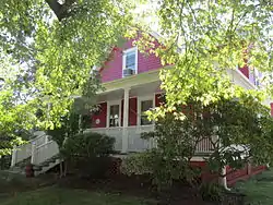 Edgewood Historic District-Shaw Plat |
March 27, 2013 (#13000120) |
Shaw and Marion Aves., parts of Narragansett Boulevard, and Broad St. 41°46′30″N 71°23′41″W |
Cranston | |
| 6 | Edgewood Yacht Club | 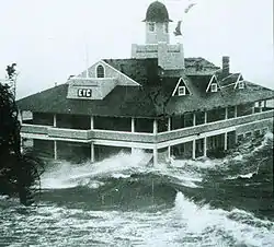 Edgewood Yacht Club |
February 23, 1989 (#89000072) |
3 Shaw Ave. 41°46′34″N 71°23′26″W |
Cranston | |
| 7 | Thomas Fenner House | 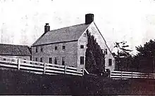 Thomas Fenner House |
March 2, 1990 (#90000143) |
43 Stony Acre Dr. 41°47′27″N 71°29′19″W |
Cranston | |
| 8 | Furnace Hill Brook Historic and Archeological District |  Furnace Hill Brook Historic and Archeological District |
August 6, 1980 (#80000097) |
off Furnace Hill Road 41°45′20″N 71°29′15″W |
Cranston | |
| 9 | Joy Homestead | 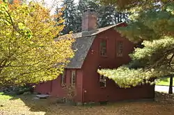 Joy Homestead |
February 18, 1971 (#71000035) |
156 Scituate Ave. 41°46′57″N 71°28′36″W |
Cranston | |
| 10 | Knightsville Meetinghouse | 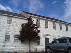 Knightsville Meetinghouse |
March 8, 1978 (#78000074) |
67 Phenix Ave. 41°46′54″N 71°28′08″W |
Cranston | |
| 11 | Lippitt Hill Historic District | 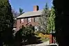 Lippitt Hill Historic District |
March 2, 1989 (#89000142) |
Hope Rd., Burlingame Rd., and Lippett Ave. 41°44′23″N 71°32′06″W |
Cranston | |
| 12 | Norwood Avenue Historic District | 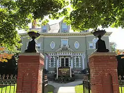 Norwood Avenue Historic District |
April 26, 2002 (#02000412) |
Roughly along Norwood Ave. between Roger Williams to Broad St. 41°46′51″N 71°24′12″W |
Cranston | Extends into Providence. |
| 13 | Oak Lawn Village Historic District | 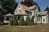 Oak Lawn Village Historic District |
November 25, 1977 (#77000004) |
Wilbur Ave. from Natick Rd. to Oaklawn Ave., includes Searle, Exchange, and Wheelock Sts. 41°44′57″N 71°29′06″W |
Cranston | |
| 14 | Pawtuxet Village Historic District | 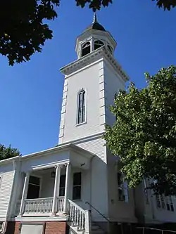 Pawtuxet Village Historic District |
April 24, 1973 (#73000050) |
Bounded roughly by Bayside, S. Atlantic, and Ocean Aves., the Pawtuxet and Providence rivers, and Post Rd. 41°45′49″N 71°23′27″W |
Cranston | |
| 15 | Potter-Remington House | December 28, 1978 (#78000006) |
571 Natick Rd. 41°44′30″N 71°29′35″W |
Cranston | ||
| 16 | Rhodes-on-the Pawtuxet Ballroom and Gazebo | 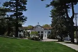 Rhodes-on-the Pawtuxet Ballroom and Gazebo |
December 12, 1978 (#78000007) |
Rhodes Pl. 41°46′04″N 71°23′32″W |
Cranston | |
| 17 | Rosedale Apartments | 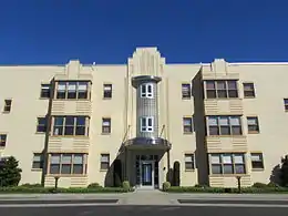 Rosedale Apartments |
April 10, 2007 (#07000301) |
1180 Narragansett Boulevard 41°46′57″N 71°23′34″W |
Cranston | |
| 18 | Sheldon House |  Sheldon House |
January 5, 1989 (#88001123) |
458 Scituate Ave. 41°46′47″N 71°29′33″W |
Cranston | |
| 19 | Gov. William Sprague Mansion |  Gov. William Sprague Mansion |
February 18, 1971 (#71000002) |
1351 Cranston St. 41°47′28″N 71°27′24″W |
Cranston | |
| 20 | Westcote | 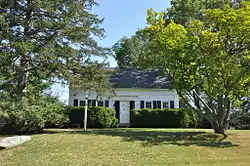 Westcote |
August 3, 1988 (#88001126) |
101 Mountain Laurel Dr. 41°45′19″N 71°28′21″W |
Cranston | |
| 21 | Nathan Westcott House | 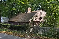 Nathan Westcott House |
January 5, 1989 (#88001124) |
150 Scituate Ave. 41°46′42″N 71°28′46″W |
Cranston | |
| 22 | Arad Wood House | 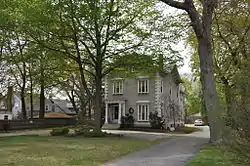 Arad Wood House |
August 3, 1988 (#88001125) |
407 Pontiac Ave. 41°46′30″N 71°26′18″W |
Cranston |
See also
References
- "National Register of Historic Places: Weekly List Actions". National Park Service, United States Department of the Interior. Retrieved on January 29, 2021.
- Numbers represent an alphabetical ordering by significant words. Various colorings, defined here, differentiate National Historic Landmarks and historic districts from other NRHP buildings, structures, sites or objects.
- "National Register Information System". National Register of Historic Places. National Park Service. March 13, 2009.
- The eight-digit number below each date is the number assigned to each location in the National Register Information System database, which can be viewed by clicking the number.
| Topics | _(extra_close)_(US48).svg.png.webp) | ||||||||||
|---|---|---|---|---|---|---|---|---|---|---|---|
| Lists by county | |||||||||||
| Lists by city |
| ||||||||||
| |||||||||||
This article is issued from Wikipedia. The text is licensed under Creative Commons - Attribution - Sharealike. Additional terms may apply for the media files.