National Register of Historic Places listings in Cumberland, Rhode Island
This is a list of Registered Historic Places in Cumberland, Rhode Island.
Bristol | Kent | Newport | Providence | Washington |
- This National Park Service list is complete through NPS recent listings posted January 29, 2021.[1]
| [2] | Name on the Register[3] | Image | Date listed[4] | Location | City or town | Description |
|---|---|---|---|---|---|---|
| 1 | Arnold Mills Historic District | 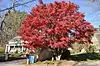 Arnold Mills Historic District |
December 28, 1978 (#78000070) |
East of Cumberland Hill at Sneech Pond, Attleboro, and Abbott Run Valley Rds. 41°58′46″N 71°23′30″W |
Cumberland | |
| 2 | Ashton Historic District | 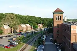 Ashton Historic District |
November 1, 1984 (#84000367) |
Roughly Mendon, Scott, and Old Angell Rds., Store Hill Rd., Front and Middle Sts. 41°56′20″N 71°25′54″W |
Cumberland | |
| 3 | Ballou-Weatherhead House | 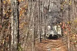 Ballou-Weatherhead House |
June 25, 1993 (#93000503) |
Tower Hill Rd. (Pole 68) 41°59′47″N 71°26′38″W |
Cumberland | |
| 4 | Berkeley Mill Village | 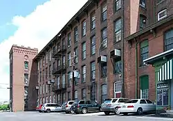 Berkeley Mill Village |
February 23, 1972 (#72000036) |
Bounded roughly by Martin St., Mendon Rd., railroad, and cemetery 41°55′39″N 71°25′25″W |
Cumberland | |
| 5 | Blackstone Canal | 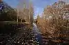 Blackstone Canal |
May 6, 1971 (#71000030) |
From Steeple and Promenade Sts. in Providence to the Massachusetts border in North Smithfield 41°55′16″N 71°25′21″W |
Lincoln, Cumberland, Woonsocket, and North Smithfield | Initial listing extended from Providence, through Pawtucket, and as far north as Lincoln; a 1991 expansion (#91001536) extended it to the state line; the canal itself extended into Worcester County, Massachusetts, where it is the subject of separate listings. |
| 6 | Burlingame-Noon House | 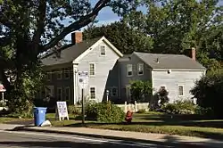 Burlingame-Noon House |
February 15, 1974 (#74000048) |
3261 Mendon Rd. 41°58′32″N 71°27′25″W |
Cumberland | |
| 7 | John Cole Farm | 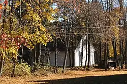 John Cole Farm |
August 16, 1977 (#77000025) |
East of Manville on Reservoir Rd. 41°59′26″N 71°24′24″W |
Cumberland | |
| 8 | Furnace Carolina Site | 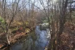 Furnace Carolina Site |
May 10, 1993 (#93000341) |
Address Restricted |
Cumberland | |
| 9 | Luke Jillson House | 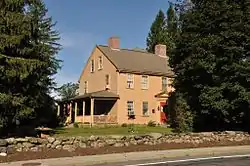 Luke Jillson House |
August 12, 1982 (#82000141) |
2510 Mendon Rd. 41°57′41″N 71°26′41″W |
Cumberland | |
| 10 | Lonsdale Historic District | 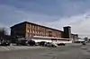 Lonsdale Historic District |
May 25, 1984 (#84002022) |
Lonsdale Ave., Blackstone Ct., and Front, Main, Cook, Broad, Mill, Cross and Blackstone Sts. 41°54′34″N 71°24′11″W |
Cumberland and Lincoln | |
| 11 | Metcalf-Franklin Farm | 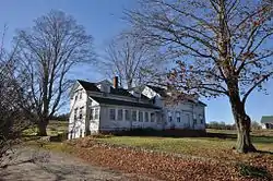 Metcalf-Franklin Farm |
June 7, 2007 (#07000526) |
142 Abbott Run Valley Rd. 41°57′56″N 71°23′37″W |
Cumberland | |
| 12 | Patterson Brothers Commercial Building and House | 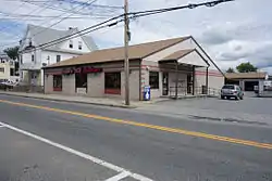 Patterson Brothers Commercial Building and House |
June 10, 1993 (#93000502) |
157, 159, and 161 Broad St. 41°54′10″N 71°23′32″W |
Cumberland | Demolished 1998. Hardware store stands on the site.[5] |
| 13 | St. Joseph's Church Complex | 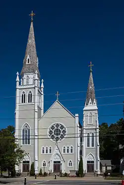 St. Joseph's Church Complex |
August 12, 1982 (#82000007) |
1303-1317 Mendon Rd. 41°56′03″N 71°25′40″W |
Cumberland | |
| 14 | Lewis Tower House | 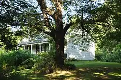 Lewis Tower House |
August 30, 1982 (#82000010) |
2199 Mendon Rd. 41°57′14″N 71°26′33″W |
Cumberland | |
| 15 | Tower-Flagg Barn Complex | May 20, 1998 (#98000574) |
100 Abbott Run Valley Rd. 41°57′33″N 71°23′34″W |
Cumberland | Demolished and replaced by housing development. | |
| 16 | Whipple-Jenckes House | 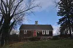 Whipple-Jenckes House |
November 5, 1992 (#92001541) |
8 Fairhaven Road 41°57′25″N 71°24′02″W |
Cumberland |
See also
References
- "National Register of Historic Places: Weekly List Actions". National Park Service, United States Department of the Interior. Retrieved on January 29, 2021.
- Numbers represent an alphabetical ordering by significant words. Various colorings, defined here, differentiate National Historic Landmarks and historic districts from other NRHP buildings, structures, sites or objects.
- "National Register Information System". National Register of Historic Places. National Park Service. March 13, 2009.
- The eight-digit number below each date is the number assigned to each location in the National Register Information System database, which can be viewed by clicking the number.
- http://www.mybroadstreetri.com/historicvaluess.htm
| Topics | _(extra_close)_(US48).svg.png.webp) | ||||||||||
|---|---|---|---|---|---|---|---|---|---|---|---|
| Lists by county | |||||||||||
| Lists by city |
| ||||||||||
| |||||||||||
This article is issued from Wikipedia. The text is licensed under Creative Commons - Attribution - Sharealike. Additional terms may apply for the media files.