National Register of Historic Places listings in Pawtucket, Rhode Island
This is a list of the National Register of Historic Places listings in Pawtucket, Rhode Island.

This is intended to be a complete list of the properties and districts on the National Register of Historic Places in Pawtucket, Rhode Island, United States. Latitude and longitude coordinates are provided for many National Register properties and districts; these locations may be seen together in an online map.[1]
There are 429 properties and districts listed on the National Register in Providence County, including 15 National Historic Landmarks. The city of Pawtucket is the location of 56 these properties and districts, including 1 National Historic Landmark; they are listed here. Properties and districts located in the county's other municipalities are listed separately. Two Pawtucket listings, the Blackstone Canal and the Conant Thread-Coats & Clark Mill Complex District, extend into other parts of Providence County, and appear on multiple lists.
Bristol | Kent | Newport | Providence | Washington |
- This National Park Service list is complete through NPS recent listings posted February 5, 2021.[2]
Current listings
| [3] | Name on the Register[4] | Image | Date listed[5] | Location | City or town | Description |
|---|---|---|---|---|---|---|
| 1 | John E. Adams House |  John E. Adams House |
November 18, 1983 (#83003804) |
11 Allen Ave. 41°52′59″N 71°22′38″W |
Pawtucket | |
| 2 | Art's Auto | 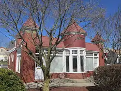 Art's Auto |
December 15, 1978 (#78000071) |
5-7 Lonsdale Ave. 41°52′07″N 71°23′56″W |
Pawtucket | |
| 3 | Blackstone Canal |  Blackstone Canal |
May 6, 1971 (#71000030) |
From Steeple and Promenade Sts. in Providence to the Massachusetts border in North Smithfield 41°55′16″N 71°25′21″W |
Pawtucket, Lincoln, Woonsocket, and North Smithfield | Initial listing extended from Providence, through Pawtucket, and as far north as Lincoln; a 1991 expansion (#91001536) extended it to the state line; the canal itself extended into Worcester County, Massachusetts, where it is the subject of separate listings. |
| 4 | Bridge Mill Power Plant | 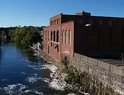 Bridge Mill Power Plant |
November 18, 1983 (#83003805) |
25 Roosevelt Ave. 41°52′35″N 71°23′04″W |
Pawtucket | |
| 5 | G.A. Burnham House |  G.A. Burnham House |
November 18, 1983 (#83003806) |
17 Nickerson St. 41°52′58″N 71°23′20″W |
Pawtucket | |
| 6 | Childs-Brown House |  Childs-Brown House |
November 18, 1983 (#83003807) |
172 Pine St. 41°52′28″N 71°23′23″W |
Pawtucket | |
| 7 | Church Hill Grammar School | 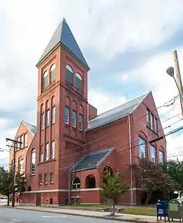 Church Hill Grammar School |
April 23, 2010 (#10000165) |
81 Park Pl. 41°52′33″N 71°23′16″W |
Pawtucket | |
| 8 | Church Hill Industrial District |  Church Hill Industrial District |
August 12, 1982 (#82000135) |
Roughly bounded by S. Union, Pine, Baley, Commerce, Main, and Hill Sts. Boundary increase (listed 2/7/2011): 60 Dexter St., 125 Goff Ave., 265 Pine St. 41°52′34″N 71°23′22″W |
Pawtucket | |
| 9 | Collyer Monument | 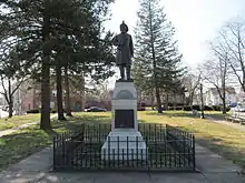 Collyer Monument |
November 18, 1983 (#83003808) |
Mineral Spring Park 41°52′29″N 71°23′35″W |
Pawtucket | |
| 10 | Conant Thread-Coats & Clark Mill Complex District | 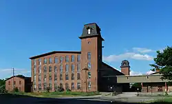 Conant Thread-Coats & Clark Mill Complex District |
November 18, 1983 (#83003809) |
Roughly bounded by Lonsdale Ave., Pine, Conant, Carpenter, and Rand Sts. 41°52′51″N 71°23′53″W |
Pawtucket | Extends into Central Falls |
| 11 | Lorenzo Crandall House |  Lorenzo Crandall House |
December 10, 1984 (#78000072) |
221 High St. 41°52′53″N 71°23′03″W |
Pawtucket | |
| 12 | Division Street Bridge | 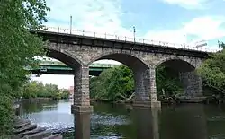 Division Street Bridge |
November 18, 1983 (#83003810) |
Division St. at the Seekonk River 41°52′20″N 71°23′06″W |
Pawtucket | |
| 13 | Downtown Pawtucket Historic District | 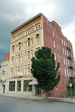 Downtown Pawtucket Historic District |
April 5, 2007 (#06001227) |
Roughly bounded by Broad St., Grant St., High St., the East Ave. Extension, and Main St. 41°52′43″N 71°23′05″W |
Pawtucket | |
| 14 | Exchange Street Historic District | 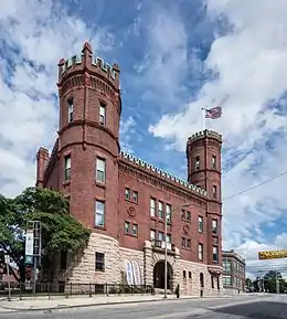 Exchange Street Historic District |
September 6, 2002 (#02000952) |
Roughly along Exchange, Front and Fountain Sts. 41°52′47″N 71°22′50″W |
Pawtucket | |
| 15 | Fifth Ward Wardroom | 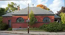 Fifth Ward Wardroom |
November 18, 1983 (#83003817) |
47 Mulberry St. 41°52′27″N 71°23′36″W |
Pawtucket | |
| 16 | Fire Station No. 4 | 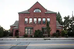 Fire Station No. 4 |
November 18, 1983 (#83003819) |
474 Broadway 41°53′11″N 71°22′36″W |
Pawtucket | |
| 17 | First Ward Wardroom | 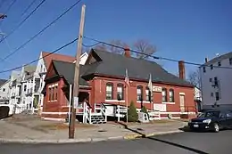 First Ward Wardroom |
November 18, 1983 (#83003820) |
171 Fountain St. 41°53′04″N 71°22′41″W |
Pawtucket | Now a VFW hall. |
| 18 | Foster-Payne House |  Foster-Payne House |
November 18, 1983 (#83003823) |
25 Belmont St. 41°51′46″N 71°23′45″W |
Pawtucket | |
| 19 | Fuller Houses |  Fuller Houses |
November 18, 1983 (#83003825) |
339-341 and 343-345 Broadway 41°53′04″N 71°22′38″W |
Pawtucket | |
| 20 | Gately Building | 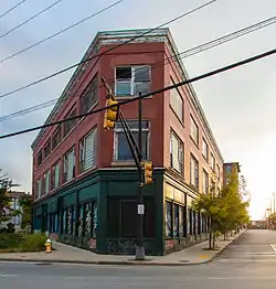 Gately Building |
March 20, 2012 (#12000135) |
335 Main St. 41°52′09″N 71°23′21″W |
Pawtucket | |
| 21 | Gilbane's Service Center Building | 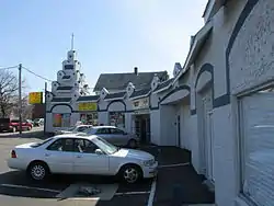 Gilbane's Service Center Building |
November 18, 1983 (#83003827) |
175-191 Pawtucket Ave. 41°52′09″N 71°23′21″W |
Pawtucket | |
| 22 | Hope Webbing Company Mill | 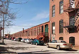 Hope Webbing Company Mill |
April 19, 2006 (#06000297) |
999-1005 Main St. 41°51′46″N 71°24′04″W |
Pawtucket | |
| 23 | Jenckes Spinning Company | 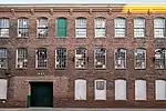 Jenckes Spinning Company |
January 25, 2018 (#100002059) |
Weeden, Barton, Pine, Lily Pond & Conant Sts. 41°52′43″N 71°23′35″W |
Pawtucket | |
| 24 | Louis Kotzow House | 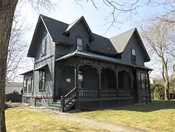 Louis Kotzow House |
November 18, 1983 (#83003829) |
641 East Ave. 41°51′37″N 71°23′24″W |
Pawtucket | |
| 25 | Leroy Theatre |  Leroy Theatre |
August 4, 1983 (#83000181) |
66 Broad St. 41°52′48″N 71°23′15″W |
Pawtucket | Demolished in 1996. |
| 26 | Liberty Arming the Patriot | 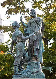 Liberty Arming the Patriot |
October 19, 2001 (#01000467) |
Park Place 41°52′37″N 71°23′14″W |
Pawtucket | |
| 27 | Main Street Bridge |  Main Street Bridge |
November 18, 1983 (#83003832) |
Main St. at Pawtucket Falls 41°52′35″N 71°23′02″W |
Pawtucket | |
| 28 | Mitchell-Arnold House |  Mitchell-Arnold House |
November 18, 1983 (#83003833) |
41 Waldo St. 41°51′58″N 71°23′27″W |
Pawtucket | |
| 29 | Modern Diner | Modern Diner |
October 19, 1978 (#78000002) |
364 East Ave. 41°52′08″N 71°23′13″W |
Pawtucket | |
| 30 | Nathaniel Montgomery House |  Nathaniel Montgomery House |
January 19, 1984 (#84002030) |
178 High St. 41°52′51″N 71°23′05″W |
Pawtucket | |
| 31 | Moore Fabric Company Plant | December 19, 2019 (#100004785) |
45-47 Washington St. 41°52′13″N 71°23′35″W |
Pawtucket | ||
| 32 | Old Slater Mill | 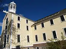 Old Slater Mill |
November 13, 1966 (#66000001) |
Roosevelt Ave. 41°52′39″N 71°22′57″W |
Pawtucket | |
| 33 | Pawtucket Armory |  Pawtucket Armory |
November 18, 1983 (#83003836) |
172 Exchange St. 41°52′49″N 71°22′49″W |
Pawtucket | |
| 34 | Pawtucket City Hall | 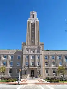 Pawtucket City Hall |
November 18, 1983 (#83003838) |
137 Roosevelt Ave. 41°52′45″N 71°22′57″W |
Pawtucket | |
| 35 | Pawtucket Congregational Church | 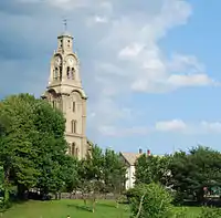 Pawtucket Congregational Church |
September 18, 1978 (#78000004) |
40 and 56 Walcott St. 41°52′36″N 71°22′54″W |
Pawtucket | Currently (2012) the church is the home to The Temple of Restoration Pentecostal Church. |
| 36 | Pawtucket Elks Lodge Building | 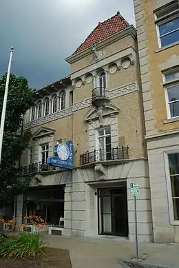 Pawtucket Elks Lodge Building |
November 18, 1983 (#83003840) |
27 Exchange 41°52′47″N 71°23′08″W |
Pawtucket | |
| 37 | Pawtucket Post Office | 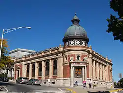 Pawtucket Post Office |
April 30, 1976 (#76000226) |
56 High St. 41°52′42″N 71°23′04″W |
Pawtucket | |
| 38 | Pawtucket Times Building | Pawtucket Times Building |
November 18, 1983 (#83003842) |
23 Exchange St. 41°52′47″N 71°23′09″W |
Pawtucket | |
| 39 | Pawtucket West High School |  Pawtucket West High School |
November 18, 1983 (#83003845) |
485 East Ave. 41°51′55″N 71°23′19″W |
Pawtucket | |
| 40 | Charles Payne House |  Charles Payne House |
November 18, 1983 (#83003847) |
25 Brown St. 41°52′17″N 71°23′29″W |
Pawtucket | |
| 41 | Phillips Insulated Wire Company Complex |  Phillips Insulated Wire Company Complex |
March 19, 2004 (#04000194) |
413 Central Ave. 41°53′04″N 71°21′59″W |
Pawtucket | |
| 42 | Pitcher-Goff House | 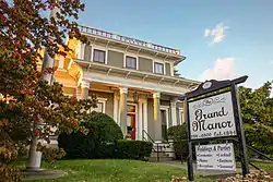 Pitcher-Goff House |
June 24, 1976 (#76000001) |
58 Walcott St. 41°52′37″N 71°22′49″W |
Pawtucket | |
| 43 | Potter-Collyer House |  Potter-Collyer House |
November 18, 1983 (#83003849) |
67 Cedar St. 41°52′24″N 71°23′23″W |
Pawtucket | |
| 44 | Prospect Heights Housing Project |  Prospect Heights Housing Project |
December 15, 2015 (#15000904) |
560 Prospect St. 41°51′41″N 71°22′01″W |
Pawtucket | |
| 45 | Quality Hill Historic District |  Quality Hill Historic District |
April 13, 1984 (#84002041) |
Roughly bounded by Interstate 95, Cottage, Lyon, Bend, and Potter Sts. 41°52′40″N 71°22′25″W |
Pawtucket | |
| 46 | Riverside Cemetery |  Riverside Cemetery |
November 18, 1983 (#83003853) |
724 Pleasant St. 41°51′33″N 71°22′56″W |
Pawtucket | |
| 47 | St. John the Baptist Church | 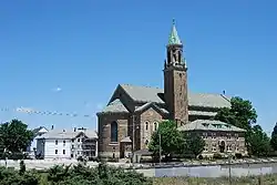 St. John the Baptist Church |
November 18, 1983 (#83003855) |
68 Slater 41°52′24″N 71°23′52″W |
Pawtucket | |
| 48 | St. Mary's Church of the Immaculate Conception Complex | 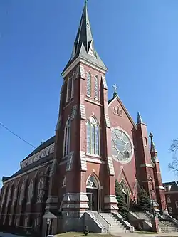 St. Mary's Church of the Immaculate Conception Complex |
November 18, 1983 (#83003856) |
103 Pine St. 41°52′17″N 71°23′21″W |
Pawtucket | |
| 49 | St. Paul's Church | 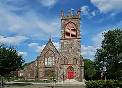 St. Paul's Church |
November 18, 1983 (#83003857) |
50 Park Pl. 41°52′32″N 71°23′14″W |
Pawtucket | |
| 50 | Deborah Cook Sayles Public Library |  Deborah Cook Sayles Public Library |
December 6, 1975 (#75000002) |
13 Summer St. 41°52′44″N 71°23′07″W |
Pawtucket | |
| 51 | Scholze-Sayles House |  Scholze-Sayles House |
November 18, 1983 (#83003859) |
625 East Ave. 41°51′39″N 71°23′21″W |
Pawtucket | |
| 52 | Slater Park | 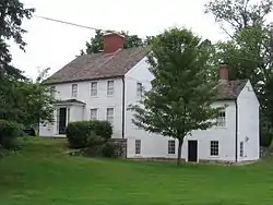 Slater Park |
June 30, 1976 (#76000004) |
Armistice Boulevard 41°52′07″N 71°20′43″W |
Pawtucket | |
| 53 | South Street Historic District | 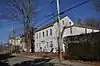 South Street Historic District |
November 18, 1983 (#83003864) |
Roughly South Street between Meadow and Fruit Sts. 41°52′17″N 71°22′47″W |
Pawtucket | |
| 54 | Joseph Spaulding House |  Joseph Spaulding House |
October 22, 1976 (#76000005) |
30 Fruit St. 41°52′26″N 71°22′50″W |
Pawtucket | |
| 55 | Standard Paper Box Corporation |  Standard Paper Box Corporation |
February 24, 2015 (#15000055) |
110 Kenyon Ave. 41°53′21″N 71°21′57″W |
Pawtucket | |
| 56 | Trinity Church | 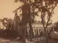 Trinity Church |
January 13, 1972 (#72000003) |
50 Main St. 41°52′33″N 71°22′52″W |
Pawtucket | Burned down in 2005 |
See also
| Wikimedia Commons has media related to National Register of Historic Places in Pawtucket, Rhode Island. |
References
- The latitude and longitude information provided in this table was derived originally from the National Register Information System, which has been found to be fairly accurate for about 99% of listings. Some locations in this table may have been corrected to current GPS standards.
- "National Register of Historic Places: Weekly List Actions". National Park Service, United States Department of the Interior. Retrieved on February 5, 2021.
- Numbers represent an alphabetical ordering by significant words. Various colorings, defined here, differentiate National Historic Landmarks and historic districts from other NRHP buildings, structures, sites or objects.
- "National Register Information System". National Register of Historic Places. National Park Service. March 13, 2009.
- The eight-digit number below each date is the number assigned to each location in the National Register Information System database, which can be viewed by clicking the number.
| Topics | _(extra_close)_(US48).svg.png.webp) | ||||||||||
|---|---|---|---|---|---|---|---|---|---|---|---|
| Lists by county | |||||||||||
| Lists by city |
| ||||||||||
| |||||||||||