National Register of Historic Places listings in Smithfield, Rhode Island
This is a list of Registered Historic Places in Smithfield, Rhode Island.
Bristol | Kent | Newport | Providence | Washington |
- This National Park Service list is complete through NPS recent listings posted January 29, 2021.[1]
| [2] | Name on the Register[3] | Image | Date listed[4] | Location | City or town | Description |
|---|---|---|---|---|---|---|
| 1 | Allenville Mill Storehouse | 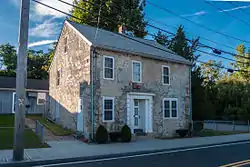 Allenville Mill Storehouse |
January 20, 1972 (#72000033) |
5 Esmond St. 41°52′41″N 71°30′09″W |
Smithfield | |
| 2 | Angell-Ballou House | 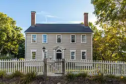 Angell-Ballou House |
March 18, 2004 (#04000196) |
49 Ridge Rd. 41°53′42″N 71°30′05″W |
Smithfield | |
| 3 | Georgiaville Historic District | 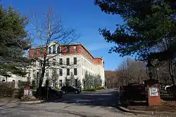 Georgiaville Historic District |
October 3, 1985 (#85002734) |
Roughly bounded by Stillwater Rd., Cross St., Whipple Ave., and Farnum Pike 41°53′18″N 71°30′26″W |
Smithfield | |
| 4 | Saint Thomas Episcopal Church and Rectory | 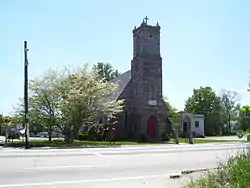 Saint Thomas Episcopal Church and Rectory |
July 2, 1987 (#87000993) |
Putnam Pike 41°52′16″N 71°33′12″W |
Smithfield | |
| 5 | Smith-Appleby House | 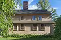 Smith-Appleby House |
May 1, 1974 (#74000005) |
Stillwater Rd. southeast of its junction with Capron Rd. 41°54′07″N 71°31′06″W |
Smithfield | |
| 6 | Smithfield Exchange Bank |  Smithfield Exchange Bank |
April 19, 2006 (#06000295) |
599 Putnam Pike 41°52′26″N 71°33′12″W |
Smithfield | |
| 7 | Ira B. Sweet House | 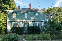 Ira B. Sweet House |
January 15, 2010 (#08000715) |
38 Esmond St. 41°52′31″N 71°30′13″W |
Smithfield | |
| 8 | Waterman-Winsor Farm | 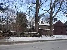 Waterman-Winsor Farm |
June 27, 1980 (#80000012) |
79 Austin Ave. 41°52′55″N 71°33′45″W |
Smithfield | |
| 9 | Stephen Winsor House | 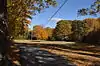 Stephen Winsor House |
October 6, 1975 (#75000004) |
113 Austin Ave. 41°53′08″N 71°33′55″W |
Smithfield | Listed at 93 Austin Ave. |
| 10 | Woonasquatucket River Site (RI-163) |  Woonasquatucket River Site (RI-163) |
November 1, 1984 (#84000364) |
near Farnum Pike[5] 41°54′33″N 71°32′21″W |
Smithfield |
See also
References
- "National Register of Historic Places: Weekly List Actions". National Park Service, United States Department of the Interior. Retrieved on January 29, 2021.
- Numbers represent an alphabetical ordering by significant words. Various colorings, defined here, differentiate National Historic Landmarks and historic districts from other NRHP buildings, structures, sites or objects.
- "National Register Information System". National Register of Historic Places. National Park Service. March 13, 2009.
- The eight-digit number below each date is the number assigned to each location in the National Register Information System database, which can be viewed by clicking the number.
- "Smithfield Reconnaissance Report" (PDF). National Park Service. Retrieved 2013-11-02.
| Topics | _(extra_close)_(US48).svg.png.webp) | ||||||||||
|---|---|---|---|---|---|---|---|---|---|---|---|
| Lists by county | |||||||||||
| Lists by city |
| ||||||||||
| |||||||||||
This article is issued from Wikipedia. The text is licensed under Creative Commons - Attribution - Sharealike. Additional terms may apply for the media files.