National Register of Historic Places listings in North Smithfield, Rhode Island
This is a list of Registered Historic Places in North Smithfield, Rhode Island.
Bristol | Kent | Newport | Providence | Washington |
- This National Park Service list is complete through NPS recent listings posted January 29, 2021.[1]
| [2] | Name on the Register[3] | Image | Date listed[4] | Location | City or town | Description |
|---|---|---|---|---|---|---|
| 1 | Peleg Arnold Tavern |  Peleg Arnold Tavern |
July 30, 1974 (#74000046) |
Woonsocket Hill Rd. 41°59′21″N 71°32′02″W |
North Smithfield | |
| 2 | Blackstone Canal |  Blackstone Canal |
May 6, 1971 (#71000030) |
From Steeple and Promenade Sts. in Providence to the Massachusetts border in North Smithfield 41°55′16″N 71°25′21″W |
Lincoln, Cumberland, Woonsocket, and North Smithfield | Initial listing extended from Providence, through Pawtucket, and as far north as Lincoln; a 1991 expansion (#91001536) extended it to the state line; the canal itself extended into Worcester County, Massachusetts, where it is the subject of separate listings. |
| 3 | Forestdale Mill Village Historic District |  Forestdale Mill Village Historic District |
June 5, 1972 (#72000041) |
East and west along Main St. and north on Maple Ave. 41°59′51″N 71°33′50″W |
North Smithfield | |
| 4 | Tyler Mowry House | 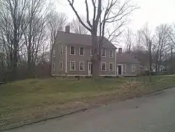 Tyler Mowry House |
August 16, 1996 (#96000904) |
112 Sayles Hill Rd. 41°57′53″N 71°30′18″W |
North Smithfield | |
| 5 | William Mowry House |  William Mowry House |
February 10, 1983 (#83000001) |
Farnum Pike 41°56′52″N 71°33′33″W |
North Smithfield | |
| 6 | Slatersville Historic District | 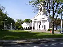 Slatersville Historic District |
April 24, 1973 (#73000002) |
Main, Green, Church, and School Sts. and Ridge Rd. 41°59′53″N 71°34′57″W |
North Smithfield | |
| 7 | Smithfield Road Historic District |  Smithfield Road Historic District |
February 18, 1987 (#87000036) |
Old Smithfield Rd., just north of Sayles Hill Road 41°58′02″N 71°29′34″W |
North Smithfield | |
| 8 | Three Dog Site, RI-151 |  Three Dog Site, RI-151 |
November 1, 1984 (#84000362) |
Off Routes 5/104 near the Smithfield line[5] |
North Smithfield | |
| 9 | Todd Farm | 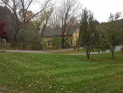 Todd Farm |
February 10, 1983 (#83000004) |
670 Farnum Pike 41°57′57″N 71°32′26″W |
North Smithfield | |
| 10 | Union Village Historic District | 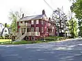 Union Village Historic District |
July 28, 1978 (#78000011) |
West of Woonsocket on RI 146A 41°59′28″N 71°32′13″W |
North Smithfield |
See also
References
- "National Register of Historic Places: Weekly List Actions". National Park Service, United States Department of the Interior. Retrieved on January 29, 2021.
- Numbers represent an alphabetical ordering by significant words. Various colorings, defined here, differentiate National Historic Landmarks and historic districts from other NRHP buildings, structures, sites or objects.
- "National Register Information System". National Register of Historic Places. National Park Service. March 13, 2009.
- The eight-digit number below each date is the number assigned to each location in the National Register Information System database, which can be viewed by clicking the number.
- Natural and Cultural Resources - North Smithfield, RI Archived 2015-12-08 at the Wayback Machine
| Topics | _(extra_close)_(US48).svg.png.webp) | ||||||||||
|---|---|---|---|---|---|---|---|---|---|---|---|
| Lists by county | |||||||||||
| Lists by city |
| ||||||||||
| |||||||||||
This article is issued from Wikipedia. The text is licensed under Creative Commons - Attribution - Sharealike. Additional terms may apply for the media files.