National Register of Historic Places listings in Foster, Rhode Island
This is a list of Registered Historic Places in Foster, Rhode Island.
Bristol | Kent | Newport | Providence | Washington |
- This National Park Service list is complete through NPS recent listings posted January 29, 2021.[1]
| [2] | Name on the Register[3] | Image | Date listed[4] | Location | City or town | Description |
|---|---|---|---|---|---|---|
| 1 | Borders Farm | 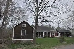 Borders Farm |
July 29, 2009 (#09000576) |
31-38 N. Rd. 41°47′17″N 71°44′38″W |
Foster | |
| 2 | Breezy Hill Site (RI-957) | September 28, 1985 (#85002700) |
Address Restricted |
Foster | ||
| 3 | Clayville Historic District | 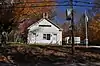 Clayville Historic District |
December 29, 1988 (#88003079) |
Roughly bounded by Cole Ave., Plainfield Pike, Field Hill Rd., and Victory Highway 41°46′37″N 71°40′35″W |
Foster and Scituate | |
| 4 | Capt. George Dorrance House | 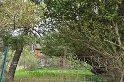 Capt. George Dorrance House |
March 16, 1972 (#72000039) |
2 Jencks Rd. 41°44′22″N 71°47′12″W |
Foster | |
| 5 | Foster Center Historic District | 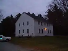 Foster Center Historic District |
May 11, 1974 (#74000050) |
Foster 41°47′07″N 71°43′18″W |
Foster | |
| 6 | Moosup Valley Historic District | 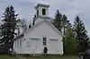 Moosup Valley Historic District |
May 11, 1988 (#88000521) |
Roughly bounded by Harrington, Johnson, Moosup Valley and Barb Hill, and Cucumber Hill Rds. 41°44′25″N 71°45′23″W |
Foster | |
| 7 | Mt. Hygeia |  Mt. Hygeia |
August 12, 1977 (#77000008) |
Mt. Hygeia Rd. 41°50′48″N 71°45′17″W |
Foster | Also known as the Solomon Drown House. |
| 8 | Mount Vernon Tavern | 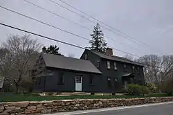 Mount Vernon Tavern |
May 8, 1974 (#74000001) |
199 Plainfield Pike (RI 14) 41°43′51″N 71°42′52″W |
Foster | |
| 9 | Hopkins Mill Historic District | 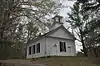 Hopkins Mill Historic District |
May 10, 1984 (#84002013) |
Old Danielson Pike, U.S. Route 6, Maple Rock and Rams Trail Rds. 41°49′21″N 71°42′25″W |
Foster | Misspelled "Nopkins" in the National Register |
See also
References
- "National Register of Historic Places: Weekly List Actions". National Park Service, United States Department of the Interior. Retrieved on January 29, 2021.
- Numbers represent an alphabetical ordering by significant words. Various colorings, defined here, differentiate National Historic Landmarks and historic districts from other NRHP buildings, structures, sites or objects.
- "National Register Information System". National Register of Historic Places. National Park Service. March 13, 2009.
- The eight-digit number below each date is the number assigned to each location in the National Register Information System database, which can be viewed by clicking the number.
| Topics | _(extra_close)_(US48).svg.png.webp) | ||||||||||
|---|---|---|---|---|---|---|---|---|---|---|---|
| Lists by county | |||||||||||
| Lists by city |
| ||||||||||
| |||||||||||
This article is issued from Wikipedia. The text is licensed under Creative Commons - Attribution - Sharealike. Additional terms may apply for the media files.