National Register of Historic Places listings in New Shoreham, Rhode Island
This is a list of Registered Historic Places in New Shoreham, Rhode Island.
Bristol | Kent | Newport | Providence | Washington |
- This National Park Service list is complete through NPS recent listings posted January 29, 2021.[1]
| [2] | Name on the Register[3] | Image | Date listed[4] | Location | City or town | Description |
|---|---|---|---|---|---|---|
| 1 | Block Island North Light | 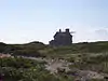 Block Island North Light |
May 23, 1974 (#74000008) |
Sandy Point, off the northern end of Corn Neck Rd. 41°13′39″N 71°34′34″W |
New Shoreham | Built in 1867; still in use with its original lens. |
| 2 | Block Island Southeast Light |  Block Island Southeast Light |
September 25, 1997 (#97001264) |
South East Light Rd. 41°09′11″N 71°32′53″W |
New Shoreham | Built in 1874; best surviving example of late 19th-century U.S. lighthouse construction. Still in use. |
| 3 | Peleg Champlin House | June 1, 1982 (#82000016) |
Rodman Pond Lane 41°11′24″N 71°35′38″W |
New Shoreham | ||
| 4 | Great Salt Pond Archeological District | February 15, 1990 (#90000107) |
Address Restricted |
New Shoreham | ||
| 5 | Hygeia House | 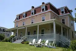 Hygeia House |
October 22, 2001 (#01001156) |
Beach Ave. 41°10′40″N 71°34′18″W |
New Shoreham | |
| 6 | Old Harbor Historic District | 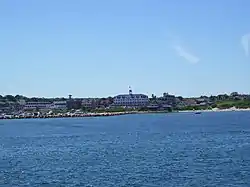 Old Harbor Historic District |
May 8, 1974 (#74000012) |
Roughly bounded by the Atlantic Ocean and Main St. (includes Spring and High Sts. and Main St.) 41°10′18″N 71°33′31″W |
New Shoreham | |
| 7 | US Weather Bureau Station | 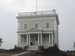 US Weather Bureau Station |
August 4, 1983 (#83000006) |
Beach Avenue 41°10′35″N 71°34′09″W |
New Shoreham |
See also
References
- "National Register of Historic Places: Weekly List Actions". National Park Service, United States Department of the Interior. Retrieved on January 29, 2021.
- Numbers represent an alphabetical ordering by significant words. Various colorings, defined here, differentiate National Historic Landmarks and historic districts from other NRHP buildings, structures, sites or objects.
- "National Register Information System". National Register of Historic Places. National Park Service. March 13, 2009.
- The eight-digit number below each date is the number assigned to each location in the National Register Information System database, which can be viewed by clicking the number.
| Topics | _(extra_close)_(US48).svg.png.webp) | ||||||||||
|---|---|---|---|---|---|---|---|---|---|---|---|
| Lists by county | |||||||||||
| Lists by city |
| ||||||||||
| |||||||||||
Municipalities and communities of Washington County, Rhode Island, United States | ||
|---|---|---|
| Towns |  Map of Rhode Island highlighting Washington County | |
| CDPs | ||
| Other villages | ||
| Indian reservation | ||
| ||
This article is issued from Wikipedia. The text is licensed under Creative Commons - Attribution - Sharealike. Additional terms may apply for the media files.