National Register of Historic Places listings in Lamoille County, Vermont
This is a list of the National Register of Historic Places listings in Lamoille County, Vermont.
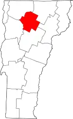
Location of Lamoille County in Vermont
This is intended to be a complete list of the properties and districts on the National Register of Historic Places in Lamoille County, Vermont, United States. Latitude and longitude coordinates are provided for many National Register properties and districts; these locations may be seen together in a map.[1]
There are 29 properties and districts listed on the National Register in the county.
- This National Park Service list is complete through NPS recent listings posted January 29, 2021.[2]
| Addison - Bennington - Caledonia - Chittenden - Essex - Franklin - Grand Isle - Lamoille - Orange - Orleans - Rutland - Washington - Windham - Windsor |
Current listings
| [3] | Name on the Register[4] | Image | Date listed[5] | Location | City or town | Description |
|---|---|---|---|---|---|---|
| 1 | Bridge 6 | 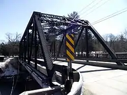 Bridge 6 |
December 20, 2007 (#07001300) |
Railroad St. 44°38′03″N 72°41′05″W |
Johnson | |
| 2 | Cambridge Meetinghouse | 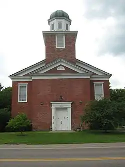 Cambridge Meetinghouse |
February 6, 1981 (#81000077) |
85 Church St.[6] 44°38′36″N 72°49′53″W |
Jeffersonville | Former multi-denominational church is now the Cambridge Town Offices and US Post Office |
| 3 | Elmore State Park | 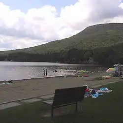 Elmore State Park |
March 29, 2002 (#02000279) |
856 VT 12 44°32′16″N 72°32′34″W |
Elmore | |
| 4 | Fisher Covered Railroad Bridge | 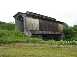 Fisher Covered Railroad Bridge |
October 1, 1974 (#74000222) |
Southeast of Wolcott, over the Lamoille River 44°31′56″N 72°25′43″W |
Wolcott | |
| 5 | Gates Farm Covered Bridge |  Gates Farm Covered Bridge |
November 19, 1974 (#74000223) |
Off VT 15, over the Seymour River 44°38′44″N 72°52′23″W |
Cambridge | |
| 6 | Gold Brook Covered Bridge | 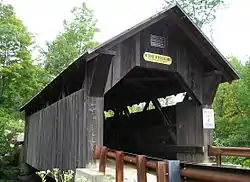 Gold Brook Covered Bridge |
October 1, 1974 (#74000224) |
South of Stowe 44°26′25″N 72°40′49″W |
Stowe | |
| 7 | Grist Mill Covered Bridge | 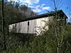 Grist Mill Covered Bridge |
June 13, 1974 (#74000225) |
East of Cambridge over the Brewster River 44°38′11″N 72°49′32″W |
Cambridge | |
| 8 | Jaynes Covered Bridge | 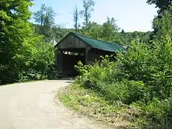 Jaynes Covered Bridge |
October 1, 1974 (#74000226) |
Northeast of Waterville, over the North Branch of the Lamoille River 44°42′43″N 72°45′23″W |
Waterville | |
| 9 | Jeffersonville Bridge | 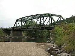 Jeffersonville Bridge |
November 14, 1991 (#91001606) |
VT 108 over the Lamoille River 44°38′57″N 72°49′51″W |
Cambridge | Replaced in 2014. |
| 10 | Jeffersonville Historic District | 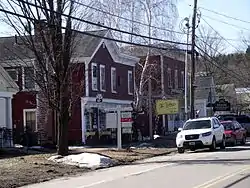 Jeffersonville Historic District |
April 10, 1987 (#86002929) |
Church, Main, Maple, and School Sts., Carlton Ave., VT 108, and Brewster Ave. 44°38′42″N 72°49′43″W |
Cambridge | |
| 11 | Johnson Railroad Depot | 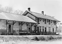 Johnson Railroad Depot |
November 28, 1980 (#80000336) |
Railroad St. 44°37′54″N 72°41′13″W |
Johnson | Probably demolished. |
| 12 | Lamoille County Courthouse | 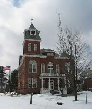 Lamoille County Courthouse |
January 11, 1996 (#95001497) |
Main St. 44°35′35″N 72°37′04″W |
Hyde Park | |
| 13 | Lamoille River Route 15-A Bridge |  Lamoille River Route 15-A Bridge |
November 14, 1991 (#91001607) |
VT 15-A over the Lamoille River 44°33′51″N 72°34′01″W |
Morristown | Pratt through truss bridge built in 1928; dismantled in 2007. |
| 14 | Mill Covered Bridge | 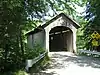 Mill Covered Bridge |
November 19, 1974 (#74000227) |
Off VT 109 over the North Branch of the Lamoille River 44°44′37″N 72°44′29″W |
Belvidere | |
| 15 | Montgomery Covered Bridge | 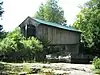 Montgomery Covered Bridge |
October 18, 1974 (#74000228) |
Northeast of Waterville over the North Branch of the Lamoille River 44°42′20″N 72°45′39″W |
Waterville | |
| 16 | Morgan Covered Bridge | 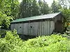 Morgan Covered Bridge |
November 19, 1974 (#74000229) |
Off VT 109, over the North Branch of the Lamoille River 44°44′36″N 72°43′37″W |
Belvidere | |
| 17 | Morrisville Historic District | 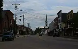 Morrisville Historic District |
January 19, 1983 (#83003210) |
Portland, Main, Railroad and Foundry Sts.; also Portland, Lower Main, Upper Main, Railroad, and Foundry Sts. 44°33′45″N 72°35′59″W |
Morrisville | Second set of boundaries represents a boundary increase |
| 18 | Moscow Village Historic District | July 31, 2008 (#08000744) |
Moscow Rd., Shaw Hill Rd., Adams Mill Rd., and River Rd. 44°26′28″N 72°42′53″W |
Stowe | ||
| 19 | Nye Block | 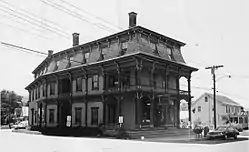 Nye Block |
August 19, 1977 (#77000144) |
Main and Railroad Sts. 44°38′07″N 72°40′54″W |
Johnson | Destroyed by fire in 1986. |
| 20 | Peoples Academy-Copley Building, Grout Observatory and Community Bandshell |  Peoples Academy-Copley Building, Grout Observatory and Community Bandshell |
March 7, 1996 (#96000255) |
5 Copley Ave. 44°33′45″N 72°35′27″W |
Morristown | |
| 21 | Poland Covered Bridge | 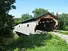 Poland Covered Bridge |
October 9, 1974 (#74000230) |
Off VT 15, over the Lamoille River 44°39′04″N 72°48′54″W |
Cambridge Junction | Officially, Cambridge Junction Bridge (see sign). Poland was a retired judge who led a lawsuit against the town to have the bridge built.[7] |
| 22 | Power House Covered Bridge | 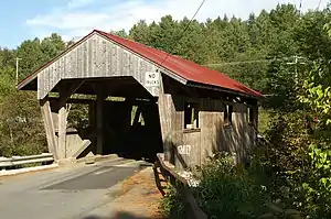 Power House Covered Bridge |
October 9, 1974 (#74000231) |
Off VT 100C, over the Gihon River 44°38′10″N 72°40′14″W |
Johnson | |
| 23 | Red Covered Bridge | 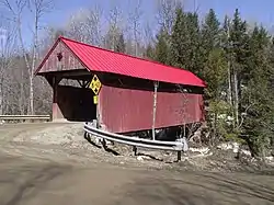 Red Covered Bridge |
October 16, 1974 (#74000232) |
Southwest of Morristown, over Sterling Brook 44°31′07″N 72°40′40″W |
Morristown | |
| 24 | Scribner Covered Bridge |  Scribner Covered Bridge |
October 1, 1974 (#74000233) |
East of Johnson over the Gihon River 44°38′20″N 72°38′57″W |
Johnson | |
| 25 | Stowe CCC Side Camp | February 14, 2002 (#02000027) |
6992 Mountain Rd. 44°31′34″N 72°46′37″W |
Stowe | ||
| 26 | Stowe Village Historic District | 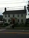 Stowe Village Historic District |
November 15, 1978 (#78000236) |
VT 100 and VT 108 44°27′58″N 72°41′09″W |
Stowe | |
| 27 | Village Covered Bridge | 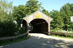 Village Covered Bridge |
December 16, 1974 (#74000234) |
Over the North Branch of the Lamoille River 44°41′24″N 72°46′16″W |
Waterville | |
| 28 | Waterman Covered Bridge | 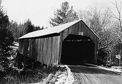 Waterman Covered Bridge |
June 13, 1974 (#74000235) |
South of Johnson over Waterman Brook 44°36′33″N 72°41′04″W |
Johnson | Collapsed in 1982. |
| 29 | Waterville Village Historic District |  Waterville Village Historic District |
September 28, 2007 (#07001026) |
VT 109, Oakes Rd., Church St., Griffin Rd., Fox Hill Rd., Beals Hill Rd., and Lapland Rd. 44°41′25″N 72°46′10″W |
Waterville |
See also
| Wikimedia Commons has media related to National Register of Historic Places in Lamoille County, Vermont. |
References
- The latitude and longitude information provided in this table was derived originally from the National Register Information System, which has been found to be fairly accurate for about 99% of listings. Some locations in this table may have been corrected to current GPS standards.
- "National Register of Historic Places: Weekly List Actions". National Park Service, United States Department of the Interior. Retrieved on January 29, 2021.
- Numbers represent an alphabetical ordering by significant words. Various colorings, defined here, differentiate National Historic Landmarks and historic districts from other NRHP buildings, structures, sites or objects.
- "National Register Information System". National Register of Historic Places. National Park Service. April 24, 2008.
- The eight-digit number below each date is the number assigned to each location in the National Register Information System database, which can be viewed by clicking the number.
- Address based on USPS website. Accessed April 11, 2016.
- http://www.virtualvermont.com/coveredbridges/cambridgejct.html
| Topics | |
|---|---|
| Lists by state |
|
| Lists by insular areas | |
| Lists by associated state | |
| Other areas | |
| Related | |
| |
Municipalities and communities of Lamoille County, Vermont, United States | ||
|---|---|---|
| Towns | Map of Vermont highlighting Lamoille County | |
| Villages | ||
| CDP | ||
| Unincorporated communities | ||
| ||
This article is issued from Wikipedia. The text is licensed under Creative Commons - Attribution - Sharealike. Additional terms may apply for the media files.