Ramban, Jammu and Kashmir
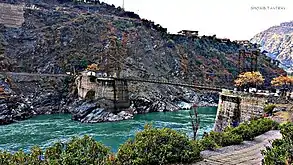
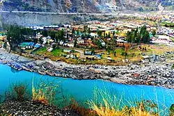
Ramban is a town in Ramban district of Jammu and Kashmir, India, which is the district headquarters of Ramban district. It lies on the banks of the Chenab river in Chenab Valley on the National Highway-1A (now NH-44) at about 150 km from Jammu and about 150 km from Srinagar, making it almost the central point on the Jammu-Srinagar National Highway.[1]

Ramban | |
|---|---|
Town | |
 | |
| Nickname(s): The 'AND' of J&K | |
 Ramban Location in Jammu and Kashmir, India  Ramban Ramban (India) | |
| Coordinates: 33.25°N 75.25°E | |
| Country | India |
| Union Territory | Jammu and Kashmir |
| District | Ramban |
| Elevation | 747 m (2,451 ft) |
| Population (2011) | |
| • Total | 3,596 |
| Literacy Rate | |
| • Town | 82.23% |
| • District | 54.27% |
| Time zone | UTC+5:30 (IST) |
| PIN | 182144 |
| Telephone Code | 01998 |
| Vehicle registration | JK 19 |
| Distance from Jammu | 150 km |
| Distance from Srinagar | 150 km |
| Website | ramban.gov.in |
History
C.E. Bats writes in his book, ‘The Gazetteer of Kashmir’, that before the formation of the J&K State in 1846, there was a small village consisting of 15 houses on the right bank of Chenab river known as Nashband (later 'Ramban'). When Raja Gulab Singh of Jammu became the Maharaja of J&K State, he adopted Jammu-Udhampur-Banihal route to reach Srinagar for the movement of royal carvans. In this process, Ramban got the status of halting station for the royal Carvans. The Dogras constructed a pacca building near present Ramban and a wooden bridge for the crossing of Chenab River. Sukhdev Singh Chadak writes in his book ‘Maharaja Ranbir Singh’ that Maharaja passed order for a cart road from Jammu to Srinagar via Banihal and a suspension bridge over Chenab River at Ramban. This road became national highway and now it is being converted into four lanes. With the development of this road, the halting station Ramban also developed a lot and now it has got the status of district headquarters.[2]
Geography


Ramban district has an average elevation of 747 metres (3792 feet). The boundary lines of Ramban district have come to be drawn from Patnitop on its south, Assar on its east, Gool on its west and Banihal on its north. Ramban district comprises seven Tehsils, namely,Banihal,Khari,Ukhrahal, Ramban,RajgarhandGool , and four community development blocks, namely, Banihal, Gool, Ramban and Ramsoo. The district consisted of 116 census villages and 127 Revenue villages in 2001. Total panchayat Halqas in District Ramban are 124.
Demographics
This data is referred to the Ramban town. For its namesake district, see 'Ramban district'
As of 2011 India census,[3] Ramban town has a population of 3,596 of which 1,873 are males while 1,723 are females.Literacy rate of Ramban town is 82.23%. In Ramban, Male literacy is around 90.42% while female literacy rate is 73.52%.[4]
Gajpat Fort
There is an important fort known as Gajpat Fort, on the top of mountain. It is said that once Sheikh Abdullah was kept imprisoned in this fort for few days. In 1825, Gulab Singh had imprisoned Raja Sultan Khan of Bimbar in this fort. Sultan Khan died there and was buried at Chanderkote. In 1858 Mean Hathu Singh, the Governor of Rajouri and a closed relatives of Maharaja had revolted against State Government and tried to kill Maharaja Ranbir Singh. Mean Hathu was arrested and shifted to Gajpat fort.[2]
Literacy Rate
- Town: 82.23%
- District: 54.27%
See also
References
- Statement showing the number of blocks in respect of 22 Districts of Jammu and Kashmir State including newly Created Districts Archived 2008-09-10 at the Wayback Machine dated 2008-03-13, accessed 2008-08-30
- "Ramban From past to present". Jammu Kashmir Latest News | Tourism | Breaking News J&K. 19 July 2015. Retrieved 18 January 2017.
- "Census of India 2001: Data from the 2001 Census, including cities, villages and towns (Provisional)". Census Commission of India. Archived from the original on 16 June 2004. Retrieved 1 November 2008.
- "Ramban City Population Census 2011 - Jammu and Kashmir". www.census2011.co.in. Retrieved 18 January 2017.