Qazigund
Qazigund, also known as Quazigund, is a town and a notified area committee in Anantnag district in the union territory of Jammu and Kashmir, India Qazigund is located at 33.59°N 75.16°E. It has an average elevation of 1670 m (5478 feet) above mean sea level.
Qazigund | |
|---|---|
Town | |
| Quazigund | |
 Qazigund Location in Jammu and Kashmir, India  Qazigund Qazigund (India) | |
| Coordinates: 33.592132°N 75.165432°E | |
| Country | |
| Union Territory | Jammu and Kashmir |
| District | Anantnag |
| Government | |
| • Body | Municipal Committee |
| Elevation | 1,670 m (5,480 ft) |
| Population (2011) | |
| • Total | 9,871 |
| Languages | |
| • Official | Urdu |
| Time zone | UTC+5:30 (IST) |
| Vehicle registration | JK03 |
Demographics
As of 2011 India census,[1] Qazigund had a population of 9871. Males constitute 55% of the population and females 45%. Qazigund has an average literacy rate of 70.21%, higher than the national average of 67.16%, male literacy is 79.82%, and female literacy is 58.27%. In Qazigund, 20.67% of the population is under 6 years of age.
Qazigund Byepass Is Via Dalwach, Chimulla & Shampora Villages.Qazigund is surrounded by springs, known as nags in the local language. Verinag source of river Jehlum is only 10 km from Qazigund. Panzath Nag is just 3 km from Qazigund and famous Vasak Nag in Kund is around 12 km from Qazigund.
There are some Sufi shrines in and around Qazigund. Khanqah of Hazrat Shahi Hamadan Ameer e Kabeer Mir Syed Ali Hamadani (RA)is located at Dooru Shahabad at a distance of 8 kilometres from Qazigund. Shrine of Hazrat Syed Noor Shah wali Baghdadi (RA) is located at Kund approximately at a distance of 12 kilometres.
Climate
| Climate data for Qazigund (1981–2010, extremes 1962–2012) | |||||||||||||
|---|---|---|---|---|---|---|---|---|---|---|---|---|---|
| Month | Jan | Feb | Mar | Apr | May | Jun | Jul | Aug | Sep | Oct | Nov | Dec | Year |
| Record high °C (°F) | 16.2 (61.2) |
19.2 (66.6) |
26.5 (79.7) |
31.4 (88.5) |
33.6 (92.5) |
35.7 (96.3) |
34.5 (94.1) |
35.0 (95.0) |
32.8 (91.0) |
32.2 (90.0) |
24.3 (75.7) |
18.1 (64.6) |
35.7 (96.3) |
| Average high °C (°F) | 6.6 (43.9) |
9.4 (48.9) |
14.4 (57.9) |
20.0 (68.0) |
23.6 (74.5) |
27.1 (80.8) |
27.9 (82.2) |
27.9 (82.2) |
26.3 (79.3) |
21.9 (71.4) |
16.2 (61.2) |
9.8 (49.6) |
19.3 (66.7) |
| Average low °C (°F) | −3.1 (26.4) |
−0.7 (30.7) |
2.8 (37.0) |
6.5 (43.7) |
9.7 (49.5) |
13.4 (56.1) |
16.6 (61.9) |
15.8 (60.4) |
11.0 (51.8) |
5.2 (41.4) |
1.0 (33.8) |
−1.5 (29.3) |
6.4 (43.5) |
| Record low °C (°F) | −15.7 (3.7) |
−16.7 (1.9) |
−7.5 (18.5) |
−1.5 (29.3) |
−0.2 (31.6) |
7.0 (44.6) |
9.4 (48.9) |
8.4 (47.1) |
4.0 (39.2) |
−1.2 (29.8) |
−8.2 (17.2) |
−14.4 (6.1) |
−16.7 (1.9) |
| Average rainfall mm (inches) | 143.2 (5.64) |
172.7 (6.80) |
192.4 (7.57) |
115.8 (4.56) |
106.4 (4.19) |
69.7 (2.74) |
115.1 (4.53) |
91.1 (3.59) |
62.5 (2.46) |
42.2 (1.66) |
44.9 (1.77) |
79.1 (3.11) |
1,235.1 (48.63) |
| Average rainy days | 7.3 | 8.4 | 9.3 | 7.9 | 7.9 | 5.4 | 7.1 | 5.7 | 3.6 | 2.7 | 2.5 | 4.6 | 72.5 |
| Average relative humidity (%) (at 17:30 IST) | 69 | 64 | 56 | 52 | 55 | 54 | 62 | 65 | 56 | 51 | 56 | 65 | 59 |
| Source: India Meteorological Department[2][3] | |||||||||||||
Transport
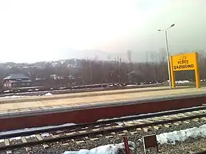
Qazigund is connected to Anantnag and Srinagar by road and railway. There is a train service from Qazigund to Srinagar ten times a day, and is connected to Kulgam by road. Qazigund is connected to Jammu and rest of India through NH 44 (former name NH 1A before renumbering of all national highways) that passes through Jawahar Tunnel of Pir Panjal mountain. New NH444 connects Qazigund to Srinagar via Shupiyan.
Banihal railway tunnel
Banihal railway tunnel or Pir Panjal Railway Tunnel, is an 11 km long railway tunnel under the Pir Panjal mountains to connect Qazigund railway station to Banihal railway station. It was bored in late 2011, became operational by 26 Dec 2012 and was commissioned in June 2013. It is India's longest and Asia's third longest railway tunnel and reduced the distance between Quazigund and Banihal to only 11 km.[4]
References
- "Census of India 2011: Data from the 2011 Census, including cities, villages and towns (Provisional)". Census Commission of India. Archived from the original on 16 June 2004. Retrieved 1 November 2008.
- "Station: Quazigund Climatological Table 1981–2010" (PDF). Climatological Normals 1981–2010. India Meteorological Department. January 2015. pp. 637–638. Archived from the original (PDF) on 5 February 2020. Retrieved 24 March 2020.
- "Extremes of Temperature & Rainfall for Indian Stations (Up to 2012)" (PDF). India Meteorological Department. December 2016. p. M78. Archived from the original (PDF) on 5 February 2020. Retrieved 24 March 2020.
- "India's longest railway tunnel unveiled in Jammu & Kashmir". The Times of India. 14 October 2011. Retrieved 14 October 2011.
| Passes | 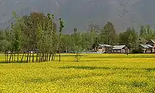 | |
|---|---|---|
| Valleys | ||
| Cities | ||
| Towns |
| |
| Rivers | ||
| Glaciers | ||
| Lakes | ||
| Mountains | ||
| Hill stations and Mughal gardens | ||
| Protected Areas | ||
| See also | ||