Kathua
Kathua (kəˈθʊə) is a city located in the Indian administered union territory of Jammu and Kashmir, near its border with Punjab and Himachal Pradesh. The town serves as District Headquarter of the district and is divided into 27 wards which constitute the Kathua Municipal Council. It is situated along NH-44. The town has a bustling industrial area and an Army Cantonment adjoining it.[1][2][3][4]

Kathua | |
|---|---|
Town | |
    clockwise from top: Atal Setu, Jasrota Fort, Industrial estate | |
 Kathua Location in Jammu and Kashmir, India  Kathua Kathua (India) | |
| Coordinates: 32.385°N 75.517°E | |
| Country | |
| Union territory | Jammu and Kashmir |
| District | Kathua |
| Settled | 1025 BC |
| Named for | Kashyapa |
| Government | |
| • Type | Municipal Council |
| • Body | Kathua Municipal Council(21) Seats |
| • Chairman Municipal Council | Naresh Sharma (BJP) |
| Area | |
| • Total | 28.32 km2 (10.93 sq mi) |
| Elevation | 393 m (1,289 ft) |
| Population (2011) | |
| • Total | 59,866 |
| • Density | 3,765/km2 (9,750/sq mi) |
| Languages | |
| Time zone | UTC+5:30 (IST) |
| PIN | 184101(HEAD OFFICE), 184104(Mini Secretariat) |
| Telephone code | 01922 |
| Literacy | 86.46% |
| Website | http://kathua.nic.in/ |
| [1][2][3][4] | |
Geography
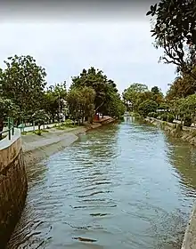
Kathua is located at 32.37°N 75.52°E.It has an average elevation of 393 metres (1,289 ft). The city is surrounded by three rivers. Ravi is just 7 km down Kathua while ujjh is about 11 km ahead on Jammu Highway. Kathua itself is situated along the banks of a khad which has been heavily polluted and encroached over there years and this has become a drain of sewage,dividing it into two boroughs: Parliwand, meaning the other side; and Orliwand, meaning this side. Itself being a Plain the area is surrounded in the North by snow capped Sivalik hills.Kathua lies 88 kilometres south of Jammu.[5]
Demographics
Population[1][2][3]
- Total population of the area (M.Cl.+OGs) is 59,688 with 31,717 males and 28,149 females. Sex ratio thus stands at 888 women per 1000 men. There are 12,061 households in the (M.Cl.+OGs) area.
Literacy[1][2][3]
- There are 46359 literates and 13,507 illiterates in the (M.Cl.+OGs) area resulting in (86.46%) literacy rate. The male and female Literacy stand at 90.7%(25,605 indv.) and 81.75%(20,754) respectively.
Language
Use of Urdu is predominant in official government documents along with English, but Dogri is the mother tongue and the vernacular language of the populace along with Hindi.
Religion
Hinduism is the largest religion in Kathua, followed by over 91% of the people. Sikhism is the second-largest religion with 4.75% adherents. Christianity and Islam form 1.09% and 2.68% of the population respectively.[6]
Tourist Attractions
Kathua has one of the most beautiful parks and gardens, one of which is Dr. K.K Birla Garden.[7] The city has a garden along the tributary of Ravi river which is famous throughout the Jammu region for its beauty. Kathua has also many small canals flowing throughout the town.[8] In addition to gardens and canals, the district of Kathua also contains historical landmarks such as Jasrota Fort and Jasmergarh Fort.
Transport
Kathua is 80 km away from Jammu city and 120 km from Katra. Interstate and Intrastate road transport is easily accessible due to the close proximity to NH44 . Jammu Airport is the nearest major airport with regular flights. The town is connected by Indian railways to all major cities of India. Intra-district transport is also easily available for travelling within the town and surrounding areas.
Climate

Kathua has a monsoon-influenced humid subtropical climate (Koppen Cwa). Kathua generally experiences extreme rainfall during the monsoon being on the windward side of Sivalik. Because of its proximity to rivers, the climate is moderate to very hot in summers and mild to very cold in winters. Summers are hot and the temperature may reach 41 degrees, while in winters, the temperature can dip to 2 degrees. Heavy downpour is experienced during the monsoon season in July and August. The annual rainfall is around 1,300 millimetres (51 in), mainly in monsoons and winters. Heavy hailstorms may be experienced in February and March, but are very rare; Kathua does not experience snowfall. Fog and sometimes Smog occur regularly during the winters, especially in January and February.
| Climate data for Kathua (1983–2010) | |||||||||||||
|---|---|---|---|---|---|---|---|---|---|---|---|---|---|
| Month | Jan | Feb | Mar | Apr | May | Jun | Jul | Aug | Sep | Oct | Nov | Dec | Year |
| Record high °C (°F) | 30.4 (86.7) |
28.6 (83.5) |
36.8 (98.2) |
43.6 (110.5) |
44.8 (112.6) |
48.0 (118.4) |
42.5 (108.5) |
39.0 (102.2) |
38.8 (101.8) |
39.6 (103.3) |
32.2 (90.0) |
28.5 (83.3) |
48.0 (118.4) |
| Mean maximum °C (°F) | 23.7 (74.7) |
26.0 (78.8) |
31.6 (88.9) |
39.1 (102.4) |
41.7 (107.1) |
42.6 (108.7) |
38.0 (100.4) |
35.9 (96.6) |
35.2 (95.4) |
34.1 (93.4) |
30.0 (86.0) |
25.3 (77.5) |
42.1 (107.8) |
| Average high °C (°F) | 18.1 (64.6) |
21.6 (70.9) |
26.5 (79.7) |
33.1 (91.6) |
37.1 (98.8) |
37.3 (99.1) |
34.1 (93.4) |
33.2 (91.8) |
32.8 (91.0) |
30.5 (86.9) |
26.5 (79.7) |
21.0 (69.8) |
29.3 (84.7) |
| Average low °C (°F) | 6.3 (43.3) |
9.1 (48.4) |
13.0 (55.4) |
17.9 (64.2) |
22.6 (72.7) |
24.6 (76.3) |
24.1 (75.4) |
23.8 (74.8) |
22.1 (71.8) |
16.6 (61.9) |
11.3 (52.3) |
7.4 (45.3) |
16.6 (61.9) |
| Mean minimum °C (°F) | 3.3 (37.9) |
4.7 (40.5) |
8.5 (47.3) |
12.1 (53.8) |
17.5 (63.5) |
20.4 (68.7) |
20.6 (69.1) |
20.6 (69.1) |
18.1 (64.6) |
12.5 (54.5) |
7.5 (45.5) |
4.1 (39.4) |
3.3 (37.9) |
| Record low °C (°F) | −1.8 (28.8) |
0.2 (32.4) |
5.6 (42.1) |
9.2 (48.6) |
14.4 (57.9) |
17.6 (63.7) |
14.0 (57.2) |
14.0 (57.2) |
11.5 (52.7) |
7.4 (45.3) |
3.6 (38.5) |
0.0 (32.0) |
−1.8 (28.8) |
| Average rainfall mm (inches) | 46.3 (1.82) |
73.2 (2.88) |
43.3 (1.70) |
35.4 (1.39) |
34.0 (1.34) |
114.7 (4.52) |
329.4 (12.97) |
425.9 (16.77) |
127.2 (5.01) |
26.9 (1.06) |
18.4 (0.72) |
20.0 (0.79) |
1,294.7 (50.97) |
| Average rainy days | 3.2 | 3.8 | 3.5 | 2.5 | 3.1 | 6.4 | 12.7 | 11.9 | 6.2 | 1.4 | 1.0 | 1.8 | 57.2 |
| Average relative humidity (%) | 86 | 80 | 72 | 56 | 47 | 61 | 83 | 87 | 83 | 75 | 80 | 86 | 75 |
| Source: India Meteorological Department[9] | |||||||||||||


References
- Directorate of Census Operations, Jammu and Kashmir (n.d.). District Census Handbook Kathua (Part-A) (PDF) (Report). pp. 8–17, 33–40, 44–47, 55, 56, 287, 296.
- Directorate of Census Operations, Jammu and Kashmir (n.d.). District Census Handbook Kathua (Part-B) (PDF) (Report). pp. 7–14, 28–29, 36–39.
- "District Kathua, Jammu& Kashmir".
- "Housing and Urban Development Department, Government of Jammu & Kashmir". jkhudd.gov.in. Retrieved 14 May 2020.
- Falling Rain Genomics, Inc - Kathua
- "Kathua City Population". Census India. Retrieved 27 September 2020.
- https://kathua.nic.in/tourist-places/
- https://www.nativeplanet.com/kathua/
- "1981-2010 CLIM NORMALS (STATEWISE).pdf" (PDF). India Meteorological Department. pp. 399–400. Archived from the original (PDF) on 5 February 2020. Retrieved 24 March 2020.
External links
- History of Kathua
- Official website of District Kathua (J&K)
- mykathua.com - A web portal about kathua