Budgam
Budgam, known as Badgom in Kashmiri, is a town and a notified area committee in Budgam district in the union territory of Jammu and Kashmir, India.
Budgam
Badgom | |
|---|---|
town | |
 Budgam Location in Jammu and Kashmir, India  Budgam Budgam (India)  Budgam Budgam (Asia) | |
| Coordinates: 34.015°N 74.722°E | |
| Country | |
| Union territory | Jammu and Kashmir |
| District | Budgam |
| Founded by | Ayatollah Aga Syed Yousuf Mosavi and Sheikh Mohammad Abdullah |
| Government | |
| • Type | Democratic |
| • Body | Nagar Palika |
| Area | |
| • Total | 10.08 km2 (3.89 sq mi) |
| Elevation | 1,610 m (5,280 ft) |
| Population (2011)[1] | |
| • Total | 15,338 |
| • Density | 1,500/km2 (3,900/sq mi) |
| Languages | |
| • Official | Urdu and English |
| Time zone | UTC+5:30 (IST) |
| Vehicle registration | JK 04 |
| Website | budgam |
Demographics
As of 2001 India census,[2] Budgam had a population of 15,932. Males constitute 69% of the population and females 31%. Budgam has an average literacy rate of 68%, higher than the national average of 59.5%; with 81% of the males and 19% of females literate. 6% of the population is under 6 years of age.
About 25℅ of the Muslim population of Budgam district belong to Shia sect.
.
Transport
Road
Budgam is connected with National Highway 444 to rest of India.
Railways
Budgam has two Railway stations on the Jammu–Baramulla line called Budgam railway station (Ompora) and Mazhom railway station.
Tehsils of Budgam
Municipal committee
Keys: INC (6) BJP (4) Vacant (3)
| # | Name | Municipal Ward | Reservation Status | Party |
|---|---|---|---|---|
| 1 | Dilsahada Banoo | Ganie Mohalla | Women Open | INC |
| 2 | Mehraj Ud Din Dar | Khanpora | Open | INC |
| 3 | Vacant | Haknipora | Open | N/A |
| 4 | Razia Hassan | Wahadatpora | Women Open | INC |
| 5 | Mushtaq Ahmad Bhat | Bazar Mohalla | Open | INC |
| 6 | Hakim Rohullah Gazi | Karipora | Open | INC |
| 7 | Shahnaza Hussain | Narispora | Women Open | BJP |
| 8 | Samiullah Bhat | Housing Colony Ompora | Open | BJP |
| 9 | Gh. Rasool Bhat | Dobi Mohallah | Open | BJP |
| 10 | Vacant | Kaisie Mohalla | Women Open | N/A |
| 11 | Vacant | Parray Angan | Open | N/A |
| 12 | Hakim Rohulla Gazi | Kharpora | Open | INC |
| 13 | Nisar Ahmad Najar | Mohanpora | Open | BJP |
References
- A-4 Towns And Urban Agglomerations Classified By Population Size Class In 2011 With Variation Since 1901. Office of the Registrar General & Census Commissioner, Ministry of Home Affairs, Government of India (Report).
Class - IV Population of 10,000 and 19,999 (Report). - "Census of India 2001: Data from the 2001 Census, including cities, villages and towns (Provisional)". Census Commission of India. Archived from the original on 16 June 2004. Retrieved 1 November 2008.
External links
| Passes | 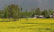 | |
|---|---|---|
| Valleys | ||
| Cities | ||
| Towns |
| |
| Rivers | ||
| Glaciers | ||
| Lakes | ||
| Mountains | ||
| Hill stations and Mughal gardens | ||
| Protected Areas | ||
| See also | ||
| Subdivisions | |
|---|---|
| Municipalities | |
| Tehsils | |
| Blocks | |
| Tourist attractions |
|
| Villages | |
| Railway | |
| Airport | |